Easing surf with more fun W/SW swells from the weekend

South Australian Forecast by Craig Brokensha (issued Wednesday 18th January)
Sign up to Swellnet’s newsletter and receive the South Australian Forecaster Notes and latest news sent directly to your inbox. Upon signup you'll also enter the draw to win a surf trip to P-Pass for you and a mate (there's only 2 weeks left to go). It doesn’t get much easier so click HERE to sign up now.
Best Days:
Recap
 A fun day of surf across the South Coast magnets yesterday with an offshore wind persisting most of the day. The Mid Coast was tiny early, but a great new W/SW swell kicked through the afternoon to 2ft as winds tended variable, creating clean glassy conditions.
Today the swell was struggling on the morning high tide and an inconsistent 1-1.5ft, but we should the swell kicking back to 1-2ft this afternoon on the turn of the tide as winds remain from the SE.
This week and weekend (Jan 19 - 22)
The South Coast is seeing a poor mix of S'ly windswell and W/SW swell today, but some better SW swell is due to build fill in tomorrow, generated by a weak front that's now crossing Tassie.
Middleton should offer 2-3ft waves with larger sets at Waits and Parsons, and winds will improve through the day with an E/NE tending NE breeze, possibly even further to the north into the afternoon as a weak low moves in from the west.
 The Mid Coast will ease in size, dropping off from 1-1.5ft tomorrow morning.
Into Friday the western flank of the low will be impacting the coast, directing fresh onshore S/SW tending S'ly winds into the South Coast creating poor conditions, while the Mid will be tiny.
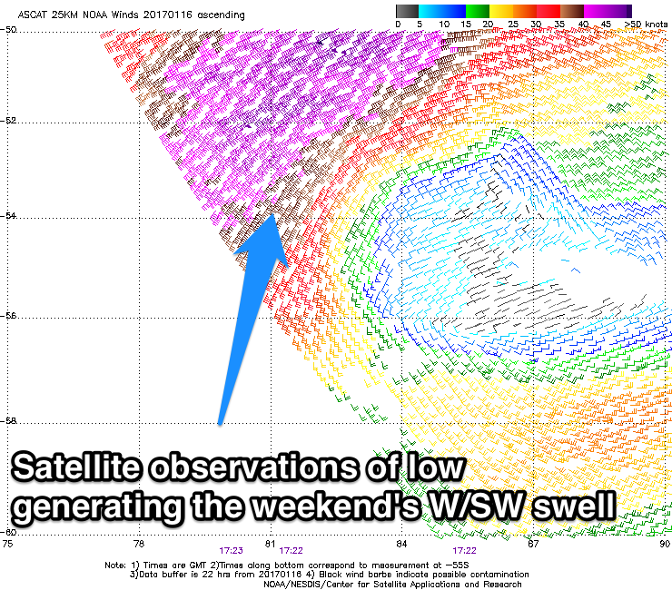
Our inconsistent but fun W/SW groundswell for the weekend is still on track, with a strong low pressure system forming in the Heard Island region earlier this week, projecting towards WA through our western swell window while producing a fetch of gale to severe-gale W/SW winds.
The low is currently weakening, leaving an inconsistent W/SW groundswell to travel towards us.
This swell is expected to build through Saturday reaching 2ft on the sets into the afternoon/evening, peaking overnight and easing from 1-1.5ft (maybe 2ft if we're lucky) Sunday morning.
The South Coast isn't due to see much size, with a small weak S'ly windswell being largest Saturday, and then Sunday when the swell peaks, only 1-2ft sets are due If that.
Winds on Saturday will be best for the Mid with a SE tending S/SE breeze, while both coasts will be clean Sunday under a morning offshore NE wind and then afternoon sea breezes.
Longer term more fun W/SW groundswell is due into all of next week, with a slow moving and persistent polar low from the south-east Indian Ocean expected to project up and through the Bight early next week.
Good amounts of W/SW swell are due into Tuesday but with S/SW winds, cleaner and easing Wednesday, but more on this Friday.
Comments
It's all about the tide on the Mid.
Swell has kicked nicely back to 2ft+ this afternoon..
Amazing light and storms offshore from Adelaide.