Good run for the South Coast

South Australian Forecast by Craig Brokensha (issued Friday 26th August)
Best Days: South Coast all weekend and most of next week
Recap
Fun 1-1.5ft sets most of yesterday with morning offshores across the Mid, while the South Coast was lumpy but clean and around 2-3ft of Middleton.
Today a new inconsistent long-period SW groundswell has come in, with waits for 2-3ft sets off Middleton and a continuation of 1-1.5ft sets on the Mid Coast. A W/NW breeze is favouring semi-protected spots down South, while the Mid was also OK with a variable wind.
This weekend (Aug 27 - 28)
Conditions will become much better at exposed breaks over the coming weekend with a moderate to fresh but easing N/NW breeze tomorrow and fresh N/NE winds Sunday.
Today's infrequent SW groundswell is expected to ease back tomorrow, with inconsistent 2ft+ sets across Middleton, better at Waits and Parsons to 4ft.
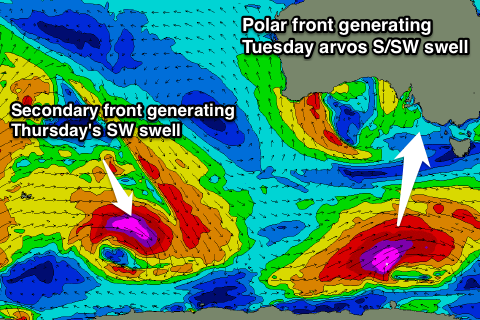
Our good pulse of SW groundswell for Sunday is still on track with a relatively weak but persistent polar front forming mid-week, projecting north-east towards us the last few days and into today.
A good kick to 3ft is expected across Middleton during the morning (if not for the odd bigger one) with 4-5ft sets at Waits and Parsons, easing through the day. The Mid Coast isn't due to see any size with 0.5-1ft sets.
Next week onwards (Aug 29 onwards)
Small surf is due into Monday, best at Waits and Parsons to 3ft+ as offshore N/NE winds persist, gusty but easing a touch through the day.
Our S/SW groundswell for Tuesday has been downgraded a touch and delayed until the middle of the day/afternoon with the polar frontal system moving a touch too fast and forming later in our swell window than ideal.
Still, a fetch of severe-gale to storm-force W/SW winds will be generated just in the South Coast's south swell window, with the swell building to a good 3-4ft across Middleton mid-late afternoon, easing rapidly from 3ft Wednesday morning. The Mid should see a tiny W/SW windswell Wednesday from a weakening mid-latitude low in the Bight, but not above 1ft+ or so.
 Conditions will remain great with a fresh N'ly tending NW breeze Tuesday and then NW winds Wednesday.
Into Thursday a mix of very inconsistent long-range W/SW groundswell and better S/SW groundswell are due across the state.
The long-range energy has and is still being generated by a strong polar low firing up in our far far swell window south-east of South Africa.
The remnants of this storm will re-intensify around the Heard Island region, projecting a tight fetch of severe-gale to storm-force W/NW winds through our south-western swell window towards the polar shelf.
Both swells are due to peak Thursday morning and our models are over-forecasting the size a little. Middleton should come in at an inconsistent 3ft to possibly 4ft with 5ft+ sets at Waits and Parsons, easing through the day. Conditions will be good though with a fresh but easing N/NE breeze. More on this Monday. Have a great weekend!
Comments
The lines are stacked at Middleton this AM.
Was good that the swell hung in there today . Interesting gale force noreast wind all day / night
good day street over the last days
Middleton pumped
Yeeeeh haaahaaa
As good as the almost coast gets,
never tubes as most south oz guys no