Calm before the storm next week

South Australian Forecast by Craig Brokensha (issued Friday 29th April)
Best Days: Exposed breaks South Coast Saturday, protected spots Sunday, Monday, Tuesday, Wednesday and Thursday experienced surfers
Recap
Good clean fun 1-2ft waves across the Mid Coast yesterday with variable winds, while the South Coast offered small fun waves, best at exposed beaches. This morning the Mid was continuing at 1-2ft but with an increasing N'ly wind, while the South Coast continued to offer fun clean waves with variable winds.
This weekend and next week (Apr 30 – May 6)
South Coast: There's no decent new swell due across the South Coast tomorrow with small leftovers around 1-2ft at Middleton and 3ft at Waits and Parsons. Conditions will be clean though with a fresh and gusty and persistent N/NW breeze.
Later in the day some new W/SW groundswell may be seen (more so on the Mid and discussed below) but Sunday will see the peak in size. Two pulses are due, the largest peaking through the day, before easing into Monday.
These two W/SW swells have been generated by back to back polar fronts pushing up and under WA, through our western swell window.
Middleton is expected to build to 4ft with 5-6ft sets at Waits and Parsons under W'ly tending W/SW winds around Victor. Winds may ease and tend back to the W/NW on dark ahead of an approaching front.
The swell will ease back through Monday from 3-4ft at Middleton and 5ft+ at Waits and Parsons under better all day offshore N/NW tending NW winds.
Now for the exciting stuff!
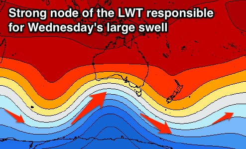 The storm that's set to generate Wednesday's extra-large SW groundswell is one of the strongest and best looking systems I've seen in a couple of years firing up into Australia.
This progression will be linked to the Long Wave Trough which is currently moving in from the west while strengthening, with it due to stall across the Bight from Sunday.
With this we'll see a vigorous polar low forming in the Heard Island region tomorrow morning, swinging ideally like a pendulum north-east up through our swell window.
An initial fetch of severe-gale to storm-force winds will weaken but grow in length and width as the systems projects north-east towards the south-east of the country, spanning some 3,000km.
This will result in a long-period XXL groundswell event for exposed breaks across Southern Australia, Victoria and Tasmania.
 Mid-period energy is due to build ahead of the larger long-period swell Tuesday, building to 5-6ft at Middleton later in the day under W/NW tending W'ly winds.
A peak in size is due Wednesday morning with very large 8ft waves off Middleton and larger 10-12ft surf at Waits and Parsons and other deep water offshore reefs.
Conditions are looking good which is rare for such a large swell with an approaching front swinging winds NW across the region.
The swell will start to ease from Wednesday afternoon/evening, slowed by trailing fetches of SW gales on the backside of the progression. Conditions should remain clean as well with NW winds ahead of a S/SW change through Friday afternoon. More on this Monday though.
Mid Coast: Tomorrow morning is likely to be a low point in activity with tiny bumpy 1ft+ waves, but later in the day the first pulse of W/SW groundswell is due, kicking to 2-3ft later in the day.
Sunday should then see 2-3ft waves all day but with onshore W/SW winds.
Into next week, easing 2ft surf is due Monday but the swell should start kicking strongly through Tuesday from 2ft through the morning to a larger 3ft+ into the late afternoon.
The peak looks to be very solid with 3-4ft of groundswell across the Mid but with those NW winds, easing through Thursday and Friday.
Comments
Is it possible that this swell will be too big for Victor Harbor ?
I'm seeing 50+ surfers at The Pines.
Options will be limited, that's for sure.
It'll be extra crowded since Swellnet put that clip up of the pines this week.
Geez you guys need to take some responsibility for exposing secret spots.
I remember a similar swell event back in July 2011. Did the usual Victor drive around.
Knights to The Dump stretch was basically a giant unsurfable washing machine.
There were a few hardy souls out at Olivers getting a thrashing and a group of boogers
and boardriders dodging closeouts at Shark Alley. The Kings, West Island zone was just
big wash throughs between the headland and the island. Went back to The Pines and it was a circus. Every surfer in a 70 km radius were strewn out between the causeway and the skatepark. Could not get a park. The almost coast.
This surfs going to be so big all the beaches will have to be closed due to dangerous conditions !
Classic post, zambezi :).
I hummed to I've been everywhere man as I read it.
I think I'll write one on the port phillip to Cape otway coast and post it on the vicco thread now.
Cmon huey
Big enough barlo ?
Decent readings on the Cape De Coudic buoy today
2ft max wave sizes tho udo it must be the wind
Nothing impressive yet still quite small with howling NW winds. A lot of W in the swell
3m @ 11secs might be good for an east coast swell but it's a blip on the radar for South Oz
2ft wave hey ryder no lie . & now the side/onshore nor wester is 40 knots its almost flattened the sea, its unusual but it does happen with nw wind . Car nearly flipped over driving along the clifftops
Crazy, is super west though, Mid Coast is bigger and 2ft+.
Tomorrow will be different.
Udo says that the cdc buoy is reading impressively today has to be a mistake right ? Safe to say that is the wrongest observation of the year so far
Haha, cummon, wouldn't say that. Good numbers for the Mid Coast! Loves mid-period swells.
But yes not impressive compared to what it can get and what's coming.
The non metro pines (pines 2),(its not that one) is about 2 foot, thundering period, really inco, and calmingly air brushed by a 631 knot NW.
Decent was the word used Caml
Impressive would be used for your boogieboard riding skills at blacks -
Lahnirose instagram
'Safe to say that is the wrongest observation of the year so far'
I hope that call wasn't the reason that we all got a mention and became infamous in that movie. Surely not for that . Oh no. I need to retract my speech.
Anyway, stay calm. The calming NW just blew a cow out to sea. Now it looks like a poor, perhaps a bit underweight lad is trapped in the breeze with it. Shit, I think its pistol! I wouldn't like to be heidi van vanity, or jervis for that matter on days like this! Keep calm!
Forecast winds for the upcoming swell look tricky. Any thoughts ?
'Haha, cummon, wouldn't say that. Good numbers for the Mid Coast! Loves mid-period swells.'
Doesn't mind a somewhat brisk, although calming, NW, slapping the buoy (not to be confused with boy) senseless, period.
Udo the creepy Instagram lurker of everything South Australian
There's an easy solution to that . Don't post as much ......
Ok cool I get it , anyways udos words are somewhat prophetic because the cdc buoy is about to snap off its top when the severest supa swell comes in tues night at about 20 metres height waves
Its gunna be on 7m ..17+secs...yammies dusting off...light nw faarrk
Vrroom vrroom..bowl could be 10ft plus..unpaddleable? Marine park..secret spots all lighting up..do we believe the hype?
Wow you reckon barley ? 18+ perhaps ? Spike likely = 10 ft
The storm seems to push a sth swell along the whole island according to the swellnet wams
Btw the island im talking about is Australia , didn't mean to bum steer
Enough swell
South is better but this event looks crazy
Bummer this swell has downgraded so much . It was saying 40ft but its dropped off badly to just 33-36ft . Wat a letdown & that winds gunner be howling
Wow, this is an interesting shocker! Looking at the weather map, who would have figured these w/sw winds and swell!!! Polish up the ski's! Charge up the go-pros! Secretly text the photographers!!! Anonymous moles on fire!!! Open the accounts!!! Udes on standby!!! Options galore, especially Yorkes!!! Gleesons boardriders rally is on!!! Team Sunsilk ho!!! Hopefully swellnet can calm things down and produce some calm waves!!!
I'm off to a secret spot. The tides are perfect too!!! Its not that one either. Or that one!?? Its open ocean!!!
Oh no!!! I just got a secret message from some friends in Adelaide. They are looking at calm perfection, and everyone is off to Yorkes!!!
Whos team sunsilk again ?
Team sunsilk are already on standby at ardrossan I heard
If ardrossan reef isn't holding the swell they have a secret river mouth at port Wakefield to charge
Little Barley there is the ringmaster of Team Sunsilk.
The abbertons were members for a few days, then overturned the leadership, booted the yorkos out, but kept their skis. It was home and away does open ocean.
Matching spray jackets, check.
Come over uplift or mrs uplift,two words, quiver, ding doctor whatever-whoever you wanna be..beers pizza footy and hopefully some nice waves..
I just returned from the secret place (not that one), (or that one), (its open ocean!!!). All was very calm. As calm as could be expected in the fluttering westerlies. I could have sworn I saw the glinting of highly polished jetskis, hair flowing in the brisk breeze, bobbing about frantically, way, way across the open ocean. Or perhaps it was the relentless fizzling windslop, slapping the buoy (not to be confused with boys) senseless.
Anyway, I had to help. Somebody had to help. So, from the newspaper weather map, I constructed a 4.5" thick, beak snouted, down railed, stringerless, assymetrical dart, designed in away to stop anything flowing over its top. And with a ridiculously powerful thrust, I hurled that dart towards the relentless glinting, towards cornball point. No doubt as one of team sunsilk, frantically screeching and hooting, gets flung into a 3 foot, windslop, draining slob, at gleesons, that magnificently propelled dart will reach its destination, and hit its lucky target right between the eye. And little Barely, will be saved by that map, simple, but elegant, saving team sunsilk from more humiliation. A gift from the desert, riding the storm!!!
All I ask in return barely is that you ride your glinting ski through the slop to southport, and deliver that map, saving thousands. Scream out the words, frosty, frosty... frosty, frosty and he will fight his way through the hapless pack. Hand that map to him, he'll know what to do with it.
Man buns secure.
Check
Nice one mick..dont have a ski...never been to southport..i do enjoy your rantings though..your actually fucking funny..