Fun swells and improving winds

Nias, Mentawai, South Sumatra forecast by Craig Brokensha (issued Tuesday 6th October)
Best Days: Every day over the coming period
This week and next week (Oct 7 - 16)
Our recent large S/SW groundswell is currently on the ease, plagued by fresh S/SE winds.
We've got two final pulses of more southerly S/SW swell into tomorrow afternoon and Thursday from a series of strong frontal systems projecting up and into Western Australia over the weekend and yesterday.
Exposed breaks should kick back to 6-8ft tomorrow afternoon and hold 6ft to occasionally 8ft Thursday before easing back into Friday and the weekend.
S/SE winds will persist tomorrow but ease from Thursday and become lighter and more variable from Friday and more so Saturday.
A couple of inconsistent but fun S/SW and SW groundswell pulses are due into Sunday and then later Monday/Tuesday, the second being a touch smaller but more consistent and from a better direction.
The S/SW pulse is currently being generated by a vigorous but small fetch of severe-gale to sub-storm-force S/SW winds in the Heard Island region, projecting north-east towards Bali.
 This should then be followed by a weaker but better positioned system developing east-southeast of Madagascar.
The first pulse for Sunday afternoon should kick to an inconsistent 4-6ft across exposed south facing breaks, easing back into Monday morning, with the secondary kick from the SW peaking Tuesday to 4-5ft.
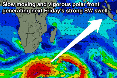
From here on the swell is then expected to ease ahead of a strong long-period and inconsistent SW groundswell Friday.
This is expected to be produced by a broad, vigorous and slow moving frontal passage firing up under South Africa later this week, aiming a fetch of severe-gale W/SW winds through our south-western swell window.
The swell from this system should peak through Friday to a strong 6-8ft+ across exposed breaks, but we'll have greater confidence on this Thursday.
16 day Mentawai forecast graph
16 day Nias forecast graph
16 day South Sumatra forecast graph
Comments
Hey Craig, sitting on the point south of Krui , and it seems the swell is a fair bit smaller than the predicted 8 ft for this morning. Been here for a couple of weeks and the swellnet forecasts have been pretty accurate. Just wondering if it's the swell direction or something . Been watching for a while now and have yet to see the odd big bomb come in.
Spoke too soon, just saw a bomb come in.
Oh cool, yeah this swell was a bit more south than the previous ones, so maybe not pushing in as well?
Let us know how it goes.
yeah the swell seems a bit South
Hey Craig, is there any updates to Mentawai coming up soon ?
Cheers
Yeah, I'll have another one on Tuesday.
bugger, will flight off in the morning, thanks anyway !
That swell for Friday is still well on track, and there's another couple possibly lining up for the middle of next week. Our model forecasts are pretty good for the region. Good luck! https://www.swellnet.com/reports/indonesia/sumatra/mentawai/forecast
thanks mate !
Hi craig,
I use and find your forecasts so good for all my local spots!, but we are heading to mentawis this Monday 12th-25th with a full boat on the mahogany,can u please give any insight or advice on wether to go north/south or even both? Hoping for head high plus uncrowded waves!!
Cheers