Easing surf, new swell Sunday, better Tuesday and Wednesday

Nias, Mentawai, South Sumatra forecast by Craig Brokensha (issued Thu 18th Sept)
Best Days: Every day besides later Friday and Saturday in the Ments and Nias region
Tomorrow and this weekend (Sep 19 - 21)
Late yesterday's strong but inconsistent pulse of new S/SW groundswell is on the ease across the Mentawai region today and will continue to drop away through tomorrow, bottoming out Saturday to an inconsistent 3ft to occasionally 4ft at super exposed breaks.
Winds should be favourable tomorrow morning before swinging average around the Ments and Nias from the west into the evening and freshening Saturday, limiting options to protected east facing breaks as the swell bottoms out, which isn't ideal. South Sumatra will see more favourable E/SE trades, becoming lighter through Saturday.
A new long-range and inconsistent S/SW groundswell is due Sunday, peaking through the afternoon, generated on the edge of our swell window to the south-west of WA. Exposed breaks in the Ments should build to an inconsistent 4-5ft+ during the day, with 6ft sets in South Sumatra, holding Monday morning before dropping through the afternoon.
Winds are due to improve and tend more variable across the Ments Sunday before fresh SE trades kick in Monday.
Next Monday onwards (Sep 22 onwards)
After the swell backs off into Monday afternoon, a couple of good pulses of S/SW groundswell are due into Tuesday and Wednesday.
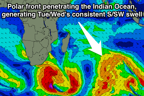 The first and initial increase (followed not far behind by the second) is being generated by a tight fetch of severe-gale to storm-force winds, producing a long-period and inconsistent S/SW groundswell for Tuesday morning.
On the tail of this low though a broader but weaker fetch of SW gales will be projected north-east through the Indian Ocean towards Eastern Indonesia, generating a more consistent S/SW groundswell for the afternoon and Wednesday morning.
Size wise, exposed spots in the Ments should reach 6-8ft Tuesday afternoon and ease from a similar size Wednesday morning with smaller surf around Nias and bigger 10ft bombs in South Sumatra. Strong SE winds will limit options in Southern Sumatra though with weaker S-S/SE winds around the Ments.
From Wednesday afternoon a steady drop in size is expected across all regions with average SW winds developing again into Friday around the Ments as the swell bottoms out.
Longer term a possible large SW groundswell discussed on Tuesday has unfortunately fallen apart with the monster polar low not looking to eventuate. We should see a new swell for Saturday still but it'll be more an inconsistent S/SW groundswell in the 6ft range. Beyond this the outlook remains active, but more on this next update on Tuesday.
16 day Mentawai forecast graph
16 day Nias forecast graph
16 day South Sumatra forecast graph
Comments
It appears we might be back in business for Fri 26th/Sat 27th?
Yeah, that polar low is now forecast to take the form some-what in between what it was originally forecasting and a much weaker version.
Can't change too much now as the storm is forecast to form through tomorrow.
Music to my ears Craig!!!
How do you think things will look for the first week of October?