Slow week, heating up from next Monday

Nias, Mentawai, South Sumatra forecast by Craig Brokensha (issued Tue 2nd Sept)
Best Days: Every day over the coming period
This week and weekend (Sep 3 - 7)
The surf's been slowly dwindling away the last few days and will continue dip away into the end of the week. Exposed spots are expected to be in the inconsistent 3ft+ range tomorrow and Thursday before throttling back to 2-3ft Friday under weak SE-S/SE winds. Moderate to fresh SE trades will develop in South Sumatra.
A small and inconsistent S/SW groundswell is due over the weekend but only to 3ft to occasional 5ft at exposed spots through the day Saturday in the Ments before easing back Sunday. Nias will be smaller, while South Sumatra should be a touch bigger.
Next week onwards (Sep 8 onwards)
 The outlook is looking much better for next week as a new node of the Long Wave Trough moves through the Southern Indian Ocean during the end of this week, bringing with it a series of strengthening polar fronts.
An initial system that's currently north-west of Heard Island should produce a fun long-range S/SW groundswell for Monday, peaking at an inconsistent 5-6ft across exposed breaks in the Ments. Expect a touch less size around Nias, while South Sumatra will be more consistent in the 6ft range.
Behind this a funky but strong trough drifting east will generate a secondary swell for Tuesday keeping 5ft+ sets hitting exposed spots. Options will be limited in South Sumatra though with stronger E/SE-SE winds.
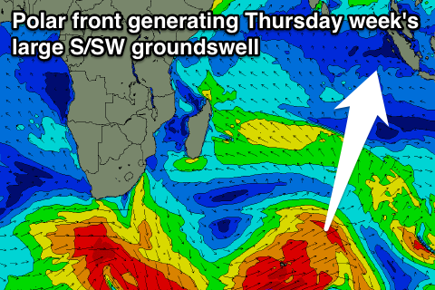
A much larger and more powerful pulse of S/SW groundswell is due late Wednesday, peaking Thursday morning though as the LWT steers a broad and powerful polar front from the Heard Island region up towards WA through Friday, Saturday and Sunday. A broad fetch of SW gales will set in motion a large S/SW groundswell that should peak in the 8-10ft range across exposed breaks in the Ments. Nias. Will probably be more around 8ft, while South Sumatra may see the odd bigger clean up bomb.
 The strong SE trades seen around South Sumatra Tuesday morning will back off a touch but remain fresh into the end of next week, while further north, lighter SE winds are due.
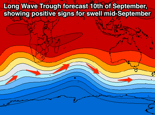
Longer term the models are still shifting around regarding a large swell for the middle of September. All indications are good for a stronger node of the LWT moving in around the 10th of September (right), but we'll have to review this again on Thursday.
16 day Mentawai forecast graph
16 day Nias forecast graph
16 day South Sumatra forecast graph
Comments
Cheers Craig. Got any longer range LWT plots you can share with us please....say around the 16th/17th Sept (or beyond) please?
Here's the 17th both 12z and 18z runs.
As you can see they're different, so It's too hard to pin down the specifics it seems at this stage.
12z
18z

Thanks Craig. Can I please have the 12z one!!! ;)
I have a question. The date and times shown in the lite black box on your WAMS. What time zone are those times for? So for the indian Ocean when it says 6pm Fri 5th what time zone is this?
The timestamp in the WAMs page is a bit all over the place sorry. It's not set for local time, it's basically AEST time, but also not totally lined up correctly with the charts at certain times of the day (something to fix).
You can get the time-step forecast in GMT by looking at the image URL, and this is probably the best way to analyse the exact forecast time of the chart.