Prolonged N/NE swell event, great late week

Eastern Tasmania Surf Forecast by Craig Brokensha (issued Monday 15th October)
Best Days: Northern corners Tuesday through Thursday, Friday, Saturday
Recap
A fun clean easing S'ly groundswell Saturday across south swell magnets, giving into a building N/NE windswell with average conditions Sunday.
Today the N/NE swell is even bigger and we should be seeing more size developing this afternoon.
Today’s Forecaster Notes are brought to you by Rip Curl
This week and weekend (Oct 16 – 21)
Currently we've got a strong stubborn high sitting in the Tasman Sea, being squeezed by a mid-latitude low that's in the Bight, directing strong and persistent NE winds down the East Coast.
This low will push slowly east tomorrow before weakening and with this we'll see stronger bursts of NE winds aimed towards us this evening, tomorrow and even into Thursday, before a change pushing in from the west pushes the NE fetch away from us later week.
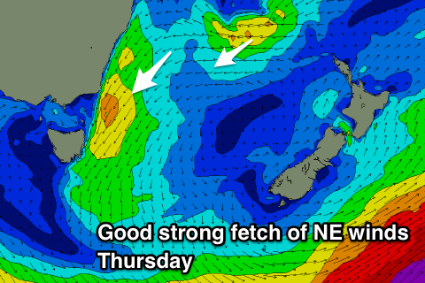 North-east facing beaches should come in around 4-5t+ tomorrow morning, easing a little through the day but persisting around 4-5ft Wednesday, with Thursday likely to kick back up to 4-5ft+ through the afternoon and then ease from 4-5ft Friday morning.
Winds look best early each morning, N'ly before tending N/NE through the day until a W/NW offshore moves in Friday morning, N/NW into the afternoon.
A stiffer offshore wind is then due Saturday with fun levels of E/NE swell easing slowly from 3ft to possibly 4ft.
Longer term there's nothing significant due until Monday/Tuesday next week when we may see a short-lived N/NE windswell, but more on this Wednesday.