South swells followed by north-east energy

Eastern Tasmania Surf Forecast by Craig Brokensha (issued Monday 8th October)
Best Days: Tuesday morning, Thursday morning, Friday morning and late at south swell magnets, Saturday morning south swell magnets
Recap
Small to tiny waves Saturday with a better mix of E/NE swells building Sunday to 3ft on the sets, easing back this morning from a smaller 2ft.
Today’s Forecaster Notes are brought to you by Rip Curl
This week and weekend (Oct 9 – 14)
The Tasman Low from last week has been lingering off the southern NSW coast all weekend and today, and we're seeing a weak fetch of E/NE winds being aimed towards us.
This should keep 2ft+ waves hitting magnets tomorrow morning, easing slowly into the afternoon and further Wednesday.
At the same time a strong polar front pushing up past us will bring a strong S/SE change after morning offshore W'ly winds.
The polar front will produce a good broad fetch of strong S/SE winds in our southern swell window, generating a late increase in windswell tomorrow ahead of a better S/SE swell Wednesday morning to the 4-5ft range but with strong S/SE winds.
 Unfortunately the stronger Tasman low that was forecast to form in the wake of this front is now due to develop east of us and aim a poorly aligned fetch of S/SE winds on the edge of our swell window.
What we'll see is easing sets out of the S/SE from 3ft to maybe 4ft at south swell magnets along with a W'ly tending SE breeze.
Friday will be smaller, with only a possible small SE pulse in the 2ft range from the unfavourably aligned fetch.
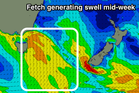
A better S'ly groundswell is due later in the day and Saturday morning, generated by a strong but tight polar low moving along the shelf this week.
A fetch of severe-gale W'ly winds will be generated through our southern swell window, with the front then going on towards New Zealand.
We should see the swell kick to 3ft late in the day Friday with NE sea breezes, easing from a similar size on Saturday morning under NW tending NE winds.
Longer term we're looking at prolonged NE swell event as a strong and stationary high pressure system moves into the Tasman Sea, squeezed by a slow moving and deepening inland surface trough.
This combo looks to project a fetch of strong and persistent NE winds through our swell window from the weekend most of next week.
We're likely to see fun levels of NE windswell coming in around 3ft+ Monday through later next week with N/NW -N/NE winds, but check back here on Wednesday for the latest on this.