Plenty of swell out of the east this week

Eastern Tasmania Surf Forecast by Craig Brokensha (issued Monday 20th August)
Best Days: Every day this week, smallest Wednesday
Recap
Tiny waves on Saturday as Friday's swell faded away, while Sunday saw a building S'ly windswell, growing in power and size into the afternoon.
The swell has eased back to 3-5ft this morning but with more east in the direction with good offshore winds, offering great waves across the open beaches.
This week and weekend (Aug 21 - 26)
Today’s Forecaster Notes are brought to you by Rip Curl
Looking at the rest of this swell event, and this morning was the biggest we'll see, with the Tasman Low not stalling as long or aiming a secondary fetch of S/SE gales as favourably in our swell window as forecast on Friday.
Last night and early this morning a fetch of S/SE gales were generated east of us, but just a little too north and on the edge of our swell window.
 As a result this morning's S/SE swell should of eased steadily, and a smaller SE swell is due tomorrow, coming in around 2-3ft across open beaches, fading from 1-2ft on Wednesday.
Winds will be best during the morning tomorrow, offshore out of the W/SW before giving into a S/SW change through the afternoon as a strong front pushes up and past us.
A small spike in S'ly windswell is likely overnight, easing back rapidly from 2ft+ or so across south magnets on Wednesday morning. Again the morning will be cleanest with a W/SW offshore, swinging E/SE into the afternoon.
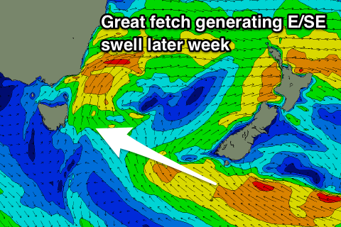
Looking at the rest of the week and we've got some fun E/SE swell pulses due from Thursday through the weekend, owing to the remnants of the Tasman Low stalling over New Zealand while aiming a persistent fetch of strong to gale-force E/SE winds through our swell window from tomorrow through Wednesday.
We should see the first pulse arriving through Thursday, with the best pulse due on Friday, easing back through the weekend.
Open beaches should build to an easy 3ft+ through Thursday with NW tending N/NE winds, with Friday's pulse coming in at 3-4ft with similar winds.
The swell will then fade through Saturday and Sunday with N'ly winds.
Longer term a deepening surface trough off the East Coast will bring much needed rain to much of the region, but also a good strengthening fetch of NE winds which will extend down to us through early next week.
With this development we're expected to see building levels of NE swell into early next week with average winds, clean and easing as the system moves off to the east, but we'll have a closer look at this on Wednesday.