Make the most of the north-east

Eastern Tasmania Surf Forecast by Craig Brokensha (issued Friday 3rd August)
Best Days: Early Saturday
Recap
The upgrade in south swell from the low pushing across us on Wednesday came in better than expected yesterday with good 2-3ft waves reported during the morning, though this would of dropped rapidly through the day.
This morning we've got the beginnings of a new N/NE windswell with bumpy 1-2ft surf. Strengthening N/NE winds off our coast will see the windswell building late today, but unfortunately the swell looks to peak overnight. More on this below.
Today’s Forecaster Notes are brought to you by Rip Curl
This weekend and next week (Aug 4 - 10)
Want to receive an email when these Forecaster Notes are updated? Then log in here and update your preferences.
This morning's initial small increase in N/NE windswell should be building stronger this afternoon as a better and broader fetch of strong N/NE winds develops to our north-east.
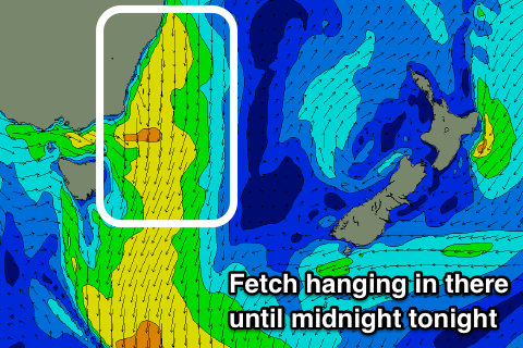 This fetch looks to reach a peak intensity a little later than forecast on Wednesday and overnight tonight which is slightly better for us, as we'll still see some fun sized sets for the early tomorrow.
North-east magnets should still be seeing 2ft sets tomorrow morning under a gusty W/NW offshore, easing rapidly through the day, so don't dawdle.
Another front approaching on Sunday will generate a poorly aligned N/NW fetch down our coast and with this no size is expected. There may be a tiny 1ft signal Monday morning, but not surfable.
We then look at a week of tiny to flat surf as a series of mid-latitude fronts push across us, bringing no love in the surf department.
Therefore try and make the most of tomorrow's small spike in NE windswell or check the South Arm forecast out. Have a great weekend!