Tiny weekend with some fun E and N/NE swell next week

Eastern Tasmania Surf Forecast by Craig Brokensha (issued Friday 8th Jun)
Best Days: Tuesday afternoon, Wednesday and Thursday
Recap
Small weak N/NE windswell to 1-2ft yesterday with average winds, more to 2ft today with better winds.
Today’s Forecaster Notes are brought to you by Rip Curl
This week and weekend (Jun 9 - 15)
Want to receive an email when these Forecaster Notes are updated? Then log in here and update your preferences.
This morning's N/NE windswell should of faded through the day under offshore winds and come tomorrow we're looking at tiny to flat leftovers.
Moving into next week, a surface trough is expected to deepen into a weak Tasman Low.
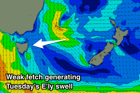 We'll see a fetch of E/SE winds aimed through our eastern swell window on the bottom flank of the low Sunday evening through Monday, slowly tending more E/NE and then away from us into Tuesday.
Some fun E'ly swell will result, filling in Tuesday to 3ft across open beaches, easing off slowly from 2-3ft Wednesday morning, though hanging in at 2ft Thursday.
Also in the mix Tuesday will be some local N/NE windswell from a strengthening fetch of N/NE winds down out coast as a deepening surface trough pushes in from the west, squeezing a high under the Tasman Low.
We're only looking at 2-3ft sets Tuesday morning, fading with a NW change through the afternoon. The morning is looking average with fresh N/NE winds.
We'll see offshore W'ly winds Wednesday through the end of the week with the small E'ly swell.
Longer term we may see another surface trough developing into a low east of us next weekend, but more on this Monday. Have a great weekend!