Dynamic week with a mix of swells and winds

Eastern Tasmania Surf Forecast by Craig Brokensha (issued Monday 9th April)
Best Days: Northern corners tomorrow afternoon, Wednesday, Friday morning, Saturday morning
Recap
Small clean surf Saturday, better Sunday with a stronger S/SE groundswell pulse offering good sets at south magnets.
This morning the swell was on the ease back from 2ft with OK winds early ahead of a S/SE change.
Today’s Forecaster Notes are brought to you by Rip Curl
This week and weekend (Apr 10 - 15)
The coming week is now looking much better and more dynamic than forecast on Friday.
Firstly the trough linked to today's change has formed into a Tasman Low today, and with this we're seeing a good fetch of strong SE winds being generated through our eastern swell window as the low retracts to the east this evening and tomorrow morning.
This should produce a good pulse of SE swell for tomorrow to 2-3ft, persisting most of the day before easing Wednesday.
Unfortunately winds will be onshore and strengthening from the NE tending N/NE tomorrow, leaving protected northern corners with the best conditions while also generating an increase in N/NE windswell.
We should see north-east facing beaches reaching 2-3ft later in the day, fading Wednesday as a W/NW tending S/SE change moves through. Dawn should reveal 2ft to maybe 3ft sets, with a drop through the day.
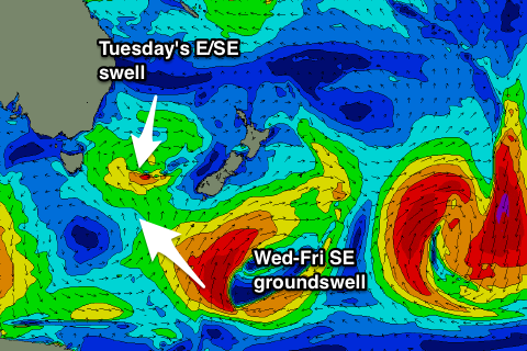 As this N/NE windswell eases, some new S/SE groundswell is expected from another strong low stalling south of New Zealand, generating a less than favourably aligned but great fetch of gale to severe-gale S/SW winds.
We'll even see a secondary slingshot of S'ly gales up towards New Zealand tomorrow, which will help produce some reinforcing S/SE groundswell late week.
No major size is expected, though we should see 3ft sets developing through Wednesday afternoon across south magnets, holding through Thursday and then easing from 2-3ft Friday.
Unfortunately another surface trough deepening north-east of us will direct fresh E'ly winds into us on Thursday, swinging SE into the afternoon, adding some poor windswell to the mix.
Winds Friday are still a little unsure but we're likely to see the trough drift east resulting in morning offshores, but check back here on Wednesday for an update on this.
From the weekend we're due to see the westerly storm track kick in and across us, bringing a drop in swell and stiff offshores. More on this Wednesday.