Strong S'ly groundswell tomorrow with a slow increase in NE groundswell

Eastern Tasmania Surf Forecast by Craig Brokensha (issued Friday 16th February)
Best Days: Saturday, Sunday morning, southern corners Monday and Tuesday, Wednesday morning, Thursday morning
Recap
Wednesday's fleeting pulse of N/NE swell faded into yesterday leaving tiny waves on the coast.
This morning there was no real sign of new NE groundswell as yet, but Sydney was also slow at dawn and has since kicked to 3-5ft.
Following this we should be starting to see some signs of swell on the coast this afternoon, hopefully reaching a very infrequent 2-3ft by dark today.
Today’s Forecaster Notes are brought to you by Rip Curl
This weekend and next week (Feb 17 - 23)
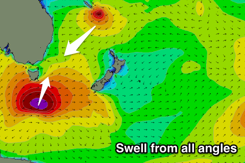
Any swell seen later today will be the least consistent of the coming forecast period, with it generated just east of the Fijian region around Tuesday this week.
From here Severe Tropical Cyclone Gita has been slowly retro-grading west towards New Caledonia, generating a fetch of strong to gale-force E/NE trade-winds with storm to hurricane-force E/NE winds at its core.
STC Gita is currently just off the south-eastern tip of New Caledonia and will maintain a fetch of storm to hurricane-force winds as well as broader NE trades while tracking in a captured fetch like motion south-west into the Tasman Sea.
 This is quite unprecedented to see a system this strong, maintain its strength and retro-grade back towards the Australian coast for such a prolonged period.
What we should see is this south-west movement generating a moderate to large powerful, NE groundswell pulse for Tuesday/Wednesday morning, but ahead of this less consistent NE groundswell should continue to build.
North-east magnets should see infrequent sets to 3ft tomorrow morning, building towards 3-5ft later in the day, holding Sunday, with Monday hopefully seeing a touch more size to 4-5ft.
Remember there'll be very long waits between sets with not much in between at all.
Tuesday's pulse should be fairly consistent with large surf to 4-6ft, possibly coming in more around 5-6ft Wednesday morning before easing rapidly through the day.
As touched on in the last few updates, with such a rare intense system with super tight but intense core winds, it's hard to nail down exact sizes of each pulse.
Coming back to tomorrow though and we should also see a strong pulse of S'ly groundswell across south swell magnets. This has been produced by an intense polar low that formed south-southwest of the state last night. A fetch of severe-gale to storm-force SW winds were projected north-east towards the Tasman Sea, with south swell magnets due to come in around 4-5ft tomorrow.
A secondary polar front should generate a smaller weaker S'ly swell for Monday and Tuesday to 2-3ft.
But looking at the local winds and tomorrow looks great with persistent fresh NW winds, while a W/NW breeze Sunday morning will give into a S/SE change late morning.
Monday then looks workable in southern corners with a S'ly tending S/SE breeze, similar Tuesday.
Early Wednesday we may see a SW breeze, tending variable ahead of E/NE sea breezes, and then morning offshores Thursday with easing levels of SE swell. More on this Monday, have a great weekend!
Comments
Saw TC Funa swell land Jan 2008, oh my goodness was that a sight to see... & surf!
I bet! Experienced the black nor’easter down in Tas. Hectic couple of days. Mother Nature at her finest and most furious. The bit that blew me away the most is I spoke to a bloke that was camping around the bay of fires area during the peak of the swell which hit overnight. They woke up in the middle of the night with ocean swooshing around them. When they came out to investigate the water was a foot deep around their tent and a second surge was bearing down on them. That one washed well past their tent taking them of there feet. Funny or crazy bit is they were about 70-80 meters back from the high tide line and behind a large rise in the sand dunes. They very promptly moved their tent to higher ground. Come morning half of the beaches were missing, massive erosion everywhere and what was left of beach grasses and shrubs had been beaten to a pulp, seaweed was in the car parks. The surf moderated a little that day and into the next, winds blew light offshore and it was on like donkey kong. Still hectic and fairly raw but epic amoungst the receding chaos. Humbling experience
Craig just for future reference to avoid getting tech savvy surfers knickers in a knot. A 193 degree SSW swell up Tasmanias East Coast is a non event - every time. The 2 biggest south swell magnets on the North East Coast on Saturday would have been pushing 1 foot on the sets and 4-5 foot is a bit ambitious. Now if we could relocate Fiji to 41 degrees south that would be a different story!!!