Plenty of N/NE swell though winds look average

Eastern Tasmania Surf Forecast by Craig Brokensha (issued Monday 13th November)
Best Days: Northern corners Wednesday and southern corners possibly on dark, southern corners early Thursday
Recap
Good clean waves easing from 2-3ft across south magnets on Saturday, down to 1-2ft yesterday, while this morning there's nothing left at all.
This week and weekend (Nov 14 - 19)
As touched on last week, we're set to see building levels of N/NE windswell through tomorrow as a surface trough moving in from the west squeezes a strong high in the Tasman Sea.
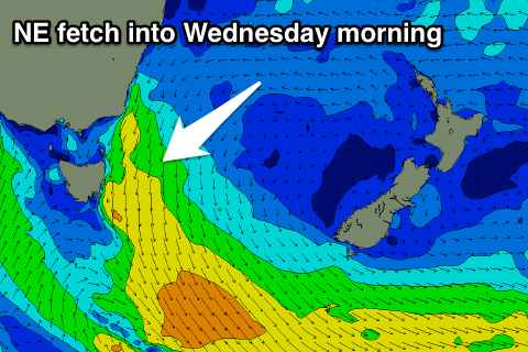 A small hint of swell is due tomorrow morning, though only to 1-2ft, but we should see sets to 3ft by later tomorrow with the fetch reaching maturity through Wednesday resulting in good 3-4ft sets across north-east facing beaches.
Winds are due to be average and from the N'th most of Wednesday, with a very late possible change more so across the southern half of the coast.
Into Thursday we'll see a S/SE change proper, with the windswell dropping rapidly as the fetch retreats Wednesday afternoon, leaving fading 2-3ft sets.
The surface trough however is expected to deepen off our coast during Thursday with a fetch of strong S/SE winds being aimed into us kicking up a poor S/SE windswell 3ft+ or so later in the day, easing from a similar size Friday though with poor winds.
We'll see the trough weakening through the weekend, and the fetch of NE winds re-establishing down our coast through early next week, kicking up new levels of N/NE windswell, but more on this Wednesday.