S'ly swell pulses through the week

Eastern Tasmania Surf Forecast by Craig Brokensha (issued Monday 6th November)
Best Days: Wednesday south magnets, Friday and Saturday morning south magnets
Recap
Nothing of real note for the weekend, while a small S'ly swell offered fun waves at south magnets today.
This week and weekend (Nov 7 - 12)
We've got a steady diet of S'ly swell this forecast period, with a series of strong polar fronts due to move through our swell window.
Firstly though you'd notice that low forming off the southern NSW coast. Unfortunately this system will be localised to that region, with no significant NE swell due for our region tomorrow above 1-2ft.
Of greater significance is a strong polar front that's currently south of the state.
This front will project up past our coast this evening and tomorrow, with a broad fetch of strong S/SW winds expected to produce a building S'ly swell through tomorrow, easing Wednesday.
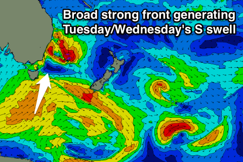 South magnets are likely to reach 3-5ft tomorrow afternoon though with SW tending S winds, easing Wednesday from 4ft or so under much better W/NW winds.
Thursday looks small and in between swell pulses, coming to 2ft at south magnets along with average SW tending S/SE winds.
Into Friday a new pulse of S'ly swell should fill in, generated by a less favourably aligned polar front moving through our swell window Wednesday and Thursday.
This swell looks to come in around 3-4ft across south facing beaches, easing back considerably overnight Friday back to a small 2ft Saturday morning.
Variable tending NE winds look to favour these south magnets, similar into Saturday with the smaller swell.
Longer term we're looking at small weak levels of N/NE windswell through next week, but to no major size at this stage. More on this Wednesday.