Good S'ly swells for the weekend

Eastern Tasmania Surf Forecast by Craig Brokensha (issued Wednesday 13th September)
Best Days: Open beaches Saturday, south magnets Sunday and dawn Monday, again Wednesday morning
Recap
A small fun SE swell yesterday morning to an inconsistent but clean 2ft on the sets, while today we've got tiny surf on the coast.
This weekend and next week (Sep 16 - 22)
Currently a very intense mid-latitude low is forming south-west of the state.
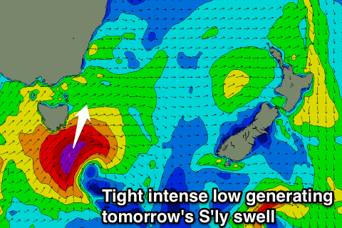 The low will move east early tomorrow morning, with a fetch of severe-gale to storm-force SW winds generated right through our southern swell window.
This should generate a solid but short-lived pulse of S'ly groundswell tomorrow morning, building to 4-5ft across south magnets mid-late morning.
We'll likely see the swell start to ease into the afternoon, with some reinforcing S'ly energy Sunday morning 3-4ft as a good fetch of S/SW gales continue through our southern swell window tomorrow afternoon and evening.
A drop will be seen through the day, with fading 1-2ft sets Monday.
Winds tomorrow won't be ideal for south facing beaches with a W/SW tending SW breeze, while Sunday looks great with a W/NW tending NW breeze.
A fetch of N'ly winds down the coast early next week look too north to generate any decent windswell, while a S/SW change pushing up past us Tuesday afternoon should generate some new S'ly windswell later in the day, better Wednesday as it eases from 2ft+ with an offshore wind.
More on this Monday. Have a great weekend!