Tons of swell, biggest Saturday afternoon/Sunday

Eastern Tasmania Forecast by Craig Brokensha (issued Wednesday 27th August)
Best Days: Thursday, Friday morning, Saturday morning, Sunday, Monday, Tuesday morning
Recap
Yesterday the surf remained tiny, but into today new levels of NE swell started to show across the coast, spreading down from a deepening low pressure system in the Tasman Sea.
This Thursday onwards (Aug 28 onwards)
From here on in we'll see varying pulses of NE tending E/NE groundswell across the coast as the low intensifies, weakens and retrogrades its way slowly south and then west through the Tasman Sea.
Strong gale-force E'ly winds aimed at the greater East Coast today will send down a strong pulse of NE groundswell for late in the day tomorrow but this won't probably arrive until after dark, with moderate amounts of swell from the bottom of the flank providing 3-4ft sets most of tomorrow. Keep an eye out for a late kick with 5ft bombs towards dark under W/NW tending N/NW winds.
Late Thursday's pulse should peak Friday morning to 4-5ft across north-east facing beaches before easing a touch into the afternoon as morning W/NW winds give into weak afternoon onshore breezes.
Now, as we move into the weekend the strongest and largest pulse of E/NE groundswell is due to fill in.
This will be a result of the low dipping south through the Tasman Sea tomorrow and Friday, projecting a fetch of E/NE gales on its south-eastern flank towards us.
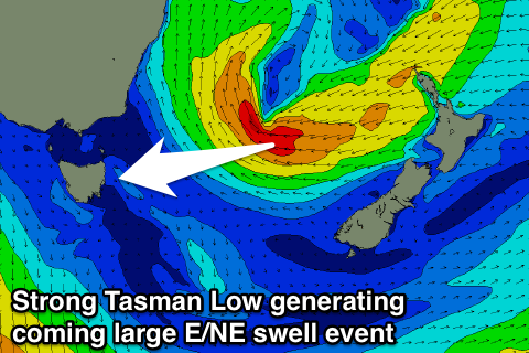 This should generate a large E/NE groundswell that is expected to arrive early Saturday morning and build strongly to 6ft+ across most open beaches, with the odd bigger set likely at offshore bommies and reefs into the afternoon.
The swell will be long lived as a broad fetch of strong to gale-force E/NE winds remain in our swell window through Friday and Saturday before the low breaks down through Sunday.
This should keep large 5-6ft+ waves hitting the coast Sunday before easing later in the day and dropping from 4-5ft or so Monday, down more noticeably from 3ft Tuesday.
Winds should remain favourable with a light variable tending NW breeze Saturday morning ahead of a shift to the N/NE into the afternoon, while Sunday looks the pick with fresh NW winds. Monday should be great also with strong NW winds, swinging W'ly through the day ahead of a late S'ly change.
Longer term we may see some new S'ly swell across our coasts through the middle to end of next week, but we'll have a closer look at this on Friday. In the meantime plan around the coming swell.
Comments
Wow!!! A bit bummed..... East coast friends phoning me.... 5 foot perfection..... :/
Why didn't ya head over? Work duties?
Several things on the go, craig, including a one car situation, wife, acreage...... I'm right down near Southport..... It's quite a hike from my place...... Solid 3 hours each way.... Oh, Lower east coast is a bit closer....
Bummer!
Yes...... Yes it is........ Better "get lucky" tonight, or the dog might just sulk and watch footy all weekend.... The grass can slash itself......... ;)