Plenty of swell energy from Sunday

Bali and Mentawais forecast by Craig Brokensha (issued Thursday 24th May)
Best Days: Swell magnets tomorrow morning, Sunday onwards
This week and next (May 25 – Jun 1)
Bali: A new long-period SW groundswell due to fill in through the day across the region today came in well across Western Australia and we should see sets to 6ft across magnets into this afternoon.
This swell is due to ease into tomorrow and further Saturday, ahead of our new large SW groundswell Sunday afternoon.
The swell has been generated over the last couple of days by a strong low in the central southern Indian Ocean, projecting a fetch of gale to severe-gale winds towards us.
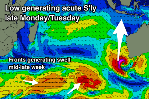
A fetch of S/SW gales are still being aimed into us this morning and will form into a severe low off the WA coast tomorrow.
The fetch around this low wasn't ideal for our swell window last update, but it's now looking a bit better, with a tight fetch of severe-gale to storm-force winds generating a new S'ly groundswell for Monday afternoon and Tuesday morning.
Coming back to the original SW groundswell though, exposed breaks should kick to 6-8ft on Sunday afternoon, easing from 6ft to occasionally 8ft through Monday morning form the S/SW fetch today.
 The S'ly groundswell for Monday afternoon and Tuesday morning should maintain 6ft+ waves later in the day, easing from 5-6ft Tuesday. With this extra south in the swell though, the Bukit will be much smaller so expect the most size later Sunday and Monday morning.
Our back to back long-period S/SW groundswells for later Tuesday and Wednesday have changed a little, with the first vigorous polar low generating a great fetch of severe-gale to storm-force W'ly winds just east of Heard Island.
The secondary system now looks a bit broader but weaker, with a fetch of gale to severe-gales racing in on the back of the low followed then by a weaker W/SW fetch.
This should result in a mix of S/SW groundswells, the first arriving later Tuesday kicking to 4-6ft at magnets by dark, with 6ft waves through Wednesday.
The models look to be combining all three swells into Wednesday afternoon and Thursday, over-forecasting the size, with the surf likely to really only hang in at 6ft+ or so across exposed breaks, easing back from later Thursday more so Friday.
Longer term a good new S/SW groundswell may be seen the following weekend, but more on this Tuesday.
Fresh E/SE trades are due over the coming period (variable each morning with local land breezes) easing off later next week.
16 day Bali Forecast Graph
16 day East Java Forecast Graph
16 day Sumbawa Forecast Graph
Ments: Some good long-period groundswell energy should be breaking on the coast today, and we'll see this easing back through tomorrow, further into Saturday.
The large S/SW groundswell from the low in the central southern Indian Ocean is expected to fill in Sunday and kick to a strong 6-8ft through the afternoon with generally light and variable winds.
The easing trend will be slow owing to the additional fetch today in our southern swell window.
This will see the swell swinging more S'th to S/SE though, and not getting into the usually protected breaks.
South magnets should ease back from 6ft to possibly 8ft Monday morning, 4-5ft Tuesday morning.
The long-period and inconsistent S/SW groundswells from the polar frontal activity isn't ideal for our region, with a kick later Tuesday, peaking Wednesday around the inconsistent 5-6ft range, holding Thursday morning and easing off later.
Winds look like they might take a S/SE-SE bias through next week which isn't ideal for south magnets, but more on this Tuesday.
16 day Mentawai forecast graph
16 day Nias forecast graph
16 day South Sumatra forecast graph
Comments
It’s amasing how much the models change from day to day.
You really can’t trust anything more than 4-5 days out hey at the most?
Depends under what kinda of pattern, right now everything is a little unsettled off WA and across the southern states.
PS yesterday's swell came in strong, reports of solid 6ft+ sets at magnets into the afternoon.
Calling the potential for 8ft again Sunday..! Maybe enough to wake up Bommie, only just.
Hope the ulus contest is 8ft when it gets going.........