Good swell tomorrow, less consistent Sunday/Monday slow into the end of the week

Bali and Mentawais forecast by Craig Brokensha (issued Thursday 14th September)
Best Days: Every day over the forecast period until late next week
This week and next (Sep 15 - 22)
Bali: We saw a fun kick in long-period S/SW groundswell later Tuesday and into yesterday, but this swell is fading back into today.
We should see a larger and more consistent S/SW groundswell filling in tomorrow, offering 6ft to occasionally 8ft sets across swell magnets tomorrow, generated earlier this week by a strong mid-latitude low firing up towards Western Australia.
The swell should start to ease later in the day, dropping more noticeably through Saturday.
 A new less consistent and slightly smaller S/SW groundswell should arrive later Saturday and build through Sunday, generated by a strong but distant polar low that formed south-east of Madagascar before tracking slowly east.
Sets should build back to an infrequent 6ft+ across exposed breaks into the afternoon, easing back from a similar if not slightly smaller range Monday.
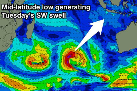
The SW groundswell for Tuesday from a tight mid-latitude low is looking better with the low due to maintain its strength a touch longer than forecast on Tuesday. We should see this swell filling in Tuesday, providing 5-6ft sets across exposed breaks into the afternoon before easing back Wednesday.
There's nothing too major due into the end of the week with a mix of inconsistent S/SW groundswell and mid-period W/SW swell due Thursday afternoon and Friday morning.
The longer term charts are a bit more exciting with a couple of mid-latitude storms due to fire up through the end of next week/weekend generating some larger more consistent surf, but more on this Tuesday.
Our recent run of weak E/SE trades will freshen a little from Saturday afternoon through Tuesday before backing off from mid-week.
16 day Bali Forecast Graph
16 day East Java Forecast Graph
16 day Sumbawa Forecast Graph
Ments: Winds should ease off out of the S/SE this afternoon and we've got easing levels of S/SW groundswell across the coast.
The swell generated by the mid-afternoon front projecting towards WA is due tomorrow across our region, building to 6ft on the sets into the afternoon, easing back into Saturday.
Another inconsistent S/SW groundswell from the polar low should fill in Sunday, with sets to 6ft due again, possibly coming in a little above this before easing back into Monday.
As touched on in the Bali notes, the SW groundswell has a bit more energy to it and should keep wave heights up in that 6ft range Tuesday before easing later in the day and further Wednesday.
A slight bump of SW swell is due Thursday but until the weekend there's nothing major on the cards.
Variable winds are expected from tomorrow, tending a little S/SE through Sunday and Monday before becoming variable again.
16 day Mentawai forecast graph
16 day Nias forecast graph
16 day South Sumatra forecast graph