Large swell to end the week, with another pulse for the weekend

Bali and Mentawais forecast by Craig Brokensha (issued Thursday 17th August)
Best Days: Experienced surfers across Bali tomorrow through Sunday, again later Wednesday and Thursday morning
This week and next (Aug 11 - 18)
Bali: Great large surf out of the S/SW the past few days with a slight drop in energy this morning, but this will only be short-lived. A large new S/SW groundswell should lift wave heights this afternoon to the 8ft+ range, easing back from 8ft or so on the sets tomorrow morning, further into Saturday.
Our large new S/SW groundswell for later Saturday and Sunday morning is still on track, with a vigorous polar frontal system projecting a fetch of gale to severe-gale SW winds into the south-west of WA.
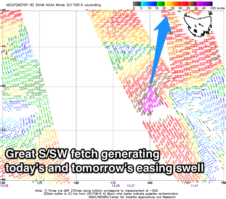 This swell has peaked this morning across WA and will push up towards us over the coming days, arriving Saturday morning and building to a large 6-8ft across exposed breaks through the afternoon, easing back from a similar size Sunday morning.
This swell will be extra south so expect the energy to become smaller than normally seen east of Bali.
The swell will continue to drop through early next week ahead of our next significant swell which is due Wednesday afternoon.
This will be generated by a vigorous polar storm currently positioned west of Heard Island.
A fetch of severe-gale W/NW tending W'ly winds will create an inconsistent but good S/SW groundswell that's due to build Wednesday, reaching an inconsistent 6ft+ by later in the day, easing back from 5-6ft Thursday morning.
From here there's nothing significant due until later next weekend when we may see a good sized S/SW groundswell, but more on this Tuesday.
Winds over the coming period are due to be lighter tomorrow, with fresh E/SE trades kicking in from Saturday (variable each morning).
16 day Bali Forecast Graph
16 day East Java Forecast Graph
16 day Sumbawa Forecast Graph
Ments: A large S'y groundswell should be filling in across our region today, with exposed south facing breaks expected to reach 6ft+ by later today, peaking tomorrow morning to 6-8ft.
The swell will then ease through Saturday, with the swell hitting Bali on the weekend being generated just out of our swell window.
 Instead moderate amounts of S/SE trade-swell are expected, with the slightly stronger pulse for Monday being downgraded a touch.
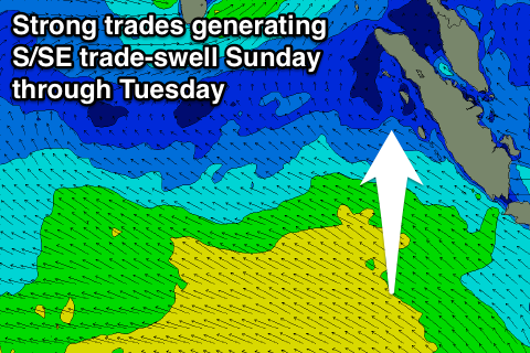
Currently a strengthening and broadening fetch of strong SE winds are forming to our south, with the fetch due to push closer to us over the coming weekend.
We'll see moderate amounts of S/SE swell generated, building through Sunday and peaking Monday to 3-5ft across exposed south facing breaks.
Winds will unfortunately become poor for these spots, with a fresh and gusty SE'ly kicking in from Saturday, persisting until late next week. With this weaker S/SE swell, more protected spots will be much smaller than seen with a S/SW groundswell.
The strong polar front forming west of Heard Island today will generate some better S/SW groundswell for Wednesday afternoon and Thursday, peaking around 4-6ft before easing into the end of the week.
16 day Mentawai forecast graph
16 day Nias forecast graph
16 day South Sumatra forecast graph
Comments
Jeez they've had a good run eh?
Have been watching WSL Pacitan comp...what a prick of a wave for a comp, short always rippy .
I was looking at the current WAMs for Indo and was trying to make sense of the scenario from 30th onwards to the 1st. There seems to be a big difference between significant wave height and peak period. On the 30th for Bali seems to be around 5ft? and the peak wave period on the same day is in at around what looks to me at easy 17/18 seconds? I am no expert obviously however i always assumed it was a pretty safe bet that long period especially 17 to 18 seconds and upwards would almost certainly guarantee a large strong swell?
I also was confused about this. It's a rather large period
Craig just following up on that big period in the wams around the 30th. Up to around 20secs?
I'm assuming that it's going to be the classic Indo 20 minute lull possibly longer and then infrequent 5 to 6 foot sets with high wave counts possibly/hopefully 4 to 5 wave sets and unlike a definitive swell event , back to long lulls with quality dependant on tides ?
Ah missed this guys, get back to you through the morning.
Ah I see what you're saying Nicko. You're asking why the 21s swell isn't forecasting bigger surf.
Well if you look at the swell analysis tab you'll see that that 21s is tiny, it starts at midday at 0.2m, reaching 0.5m by 6pm. There's an easing S/SW swell from 1.5m @ 13s or so.
This is a classic case of the 21s forerunners being over 24 hours ahead of the bulk of the swell energy.
If you follow the yellow line, you'll see this long-period swell actually peaks two days after it arrives, on Friday 1st of September and without any major size.. 1.5m @16.3s.
This is because the swell will be generated in Indo's far swell window, under South Africa. I'd expect really inconsistent 5-6ft sets at the swells peak.
More about forerunners and swell timing here: Why The Swell Train Is Often Late
Hi Craig, will there be an updated Indo forecast today or tomorrow? Heading to West Sumbawa on Friday and need to organise my quiver!
Cheers,
Ran out of time yesterday Aaron, will have one tomorrow, but we're looking at moderate swells, nothing large over the next two weeks.
Thanks for your reply Craig.
Thanks Craig.
jbay mmmmm
Too big Mick. Probably breaking wide in the bay.