Good SW swells next week, oversized swell possible long-term

Bali and Mentawais forecast by Craig Brokensha (issued Thursday 27th April)
Best Days: Friday, Saturday, later Sunday onwards
This week and next (Apr 28 - May 5)
Bali: The surf has slowly dropped away from earlier in the week and will continue to do so into this evening.
A small inconsistent reinforcing S/SW swell should keep exposed breaks topped up with 4-5ft sets tomorrow morning, easing back through the afternoon and further through the weekend.
Variable winds are due tomorrow and Saturday mornings, with weak afternoon E/SE trades, more sea breezes into the afternoons from Sunday.
Later in the day Sunday the first of two SW groundswells talked about last update are due to start building.
This first swell should reach an inconsistent but strong 3-5ft by dark across swell magnets Sunday, peaking during the day Monday to 5-6ft+.
A drop in size will be seen Tuesday, while a new SW groundswell is due to arrive later in the day, peaking Wednesday afternoon to an inconsistent 5-6ft. This secondary swell is a little better aimed but super inconsistent, with a drop due through Thursday, further into the weekend.
Winds as touched on above are due to be variable each morning with weak sea breezes, tending more E/SE mid-late week.
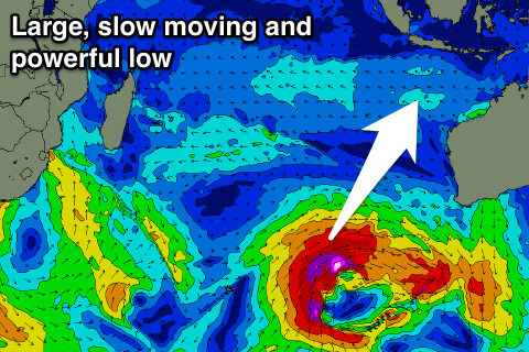 Longer term, a large S/SW groundswell event has surface on the long-range charts. A strong node of the Long Wave Trough developing in the southern Indian Ocean is forecast, and with this we'll see a vigorous polar frontal progression developing in the Heard Island region.
This system will be broad and slow moving, generating multiple fetches of severe-gale to storm-force SW winds through our southern swell window.
The slow moving nature of the progression and strong winds over an active sea state should see an oversized swell generated for Indonesia. Early estimates have it building Sunday and peaking Monday in the 10-12ft range, but more on this in the next update.
16 day Bali Forecast Graph
16 day East Java Forecast Graph
16 day Sumbawa Forecast Graph
Ments: The surf is smaller around the region today and we'll see it continue to ease back further tomorrow and Saturday. NW breezes will favour south swell magnets though, tending more variable from Sunday as the new SW groundswell starts to build.
This swell, generated by pre-frontal severe-gale to storm-force W/NW winds, should reach 4-6ft by dark ahead of a peak Monday morning to 5-6ft+.
A drop in size is due through the afternoon, further Tuesday ahead of the secondary better aligned SW swell Tuesday afternoon. A kick back to 6ft is expected, peaking Wednesday morning again around 5-6ft+.
Winds are due to remain variable through this swell and all of next week, similar into the following weekend.
The oversized S/SW groundswell for Bali will also come in large across the Mentawais, with easy 10ft sets due if the low comes off. We'll check the developments of this system again on Tuesday though.
16 day Mentawai forecast graph
16 day Nias forecast graph
16 day South Sumatra forecast graph
Comments
DP on the last swell. Looks like winds weren't perfect.