Large and dangerous swell Sunday, secondary pulse Thursday

Java, Bali, Lombok, Sumbawa forecast by Craig Brokensha (issued Thu 21st Aug)
Best Days: Late Friday, Saturday, Sunday and Monday morning for experienced surfers, Tuesday, Wednesday, Thursday for experienced surfers
This Friday through next week (Aug 22 - 29)
The swell's dropped away from a fun pulse yesterday, and we'll continue to see it fade into the afternoon and remain on the small side tomorrow morning.
A late increase in long-range S/SW groundswell is due tomorrow evening to an inconsistent 4-6ft across exposed breaks on dark before easing back from 4-5ft+ Saturday morning. Fresh E/SE trades will continue across most breaks, although selected areas should see variable winds for a couple of hours after dawn.
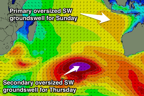
Of much greater importance is an oversized, very powerful and consistent SW groundswell due Sunday across Indonesia.
This swell has been upgraded since Tuesday's large forecast, with the enormous frontal progression generating the swell undergoing a secondary intensification yesterday under the influence of a strong amplification of the Long Wave Trough.
A vast area of open ocean swell over 40ft, about the size of Victoria, has been produced in the Southern Indian Ocean, with this swell expected to move up and towards us over the coming days, arriving overnight Saturday and peaking through the middle of the day Sunday.
 Exposed spots are now expected to offer enormous 12ft+ surf with 15ft bombs with even protected spots likely coming in too big across most regions. Strong E/SE trades will limit options to protected breaks before easing through next week as the swell steadily drops away.
Monday morning will still be large and powerful though with the swell tending a touch more S/SW and easing from 10ft+ across exposed breaks.
A low point in swell is pencilled in for Wednesday morning, but this will only be temporary as the secondary large and powerful SW groundswell arrives late in the day before a peak on Thursday.
The source of this swell will be another vigorous polar front firing up in the Southern Indian Ocean under the effects of the Long Wave Trough, projecting a fetch of severe-gale to storm-force SW and then W/SW winds towards us in a couple of bursts.
This system won't be as long-lived and be a touch less consolidated but in saying this, a very large and powerful SW groundswell will still result, peaking through the middle of the day to 10-12ft at exposed breaks around Bali.
The E/SE trades will be weaker so morning variable winds across selected locations should open up plenty of options for experienced boardriders.
From here on the strong node of the Long Wave Trough is forecast to shift slowly off to the east and under Australia resulting in a drop in swell activity into the start of September. More on this next Tuesday though.
16 day Bali Forecast Graph
16 day East Java Forecast Graph
16 day Sumbawa Forecast Graph
Comments
Hi Craig
I'm in Bali, was hoping to get some solid waves tomorrow,
everyone calling bigger than the last swell 2weeks back when
they held final Padang Cup.
However I heard swell in WA came in well under predicted size!
Do you have any thoughts on this?
Cheers for any more info!
Hi Craig
I'm in Bali, was hoping to get some solid waves tomorrow,
everyone calling bigger than the last swell 2weeks back when
they held final Padang Cup.
However I heard swell in WA came in well under predicted size!
Do you have any thoughts on this?
Cheers for any more info!
Jug, looked like swell didn't really kick until later/overnight with the peak on the Albany buoy shown this morning, whereas it was expected during the early morning. Other buoys are offline which is really frustrating.
The numbers are bigger than the last Padang swell, but the core winds of the storm weren't as strong, so the period will be a touch lower which may stop it fully wrapping in as hard as it did last swell.
Be very big though, let us know how you go.
Thanks Craig
Any prediction of time the swell will peak?
Last Padang swell was solid at Ulu and had some great waves,
But there was a cross swell on it which created peaky conditions at different times of the day. Great at times though
I'll keep ya updated.
Oh, Lachy 22, from Hornsby got some bombs!
I'd say midday/early afternoon. But probably most consistent on that incoming tide.
Welly, are you at sea nw w.a. hows the ocean conditions today ....corduroy lines heading north ?
Yeah Udo woke up to strong ssw winds and messy sea state but strong lines, wind went se-e about 10am and swell cleaned up fast, real nice lines all day, was looking at Ben and Craigs forecast for sexmouth today and they hit it on the head with swell size/period and direction.
From the Captain on board he said the bouy on NW cape was reading 4.0m at arvo smoko and around 16 sec period.
Hey craig and jughead , swell was more than 12 hrs late in westoz . Period was lower than forcast although it did show up later with a peak of 17 for a few hrs . The rotto jurien gero and albany bouys were available still . Good amount of size up the norwest so u might be lucky jug . Be calm relax , then meet swell much later than expected . Semoga ombak besar
Welly your captain must be reading max height . Jurien didnt
Wellymon ask for significant height maybe ?
Ah thanks everyone, hope ya got sim Camel.
I'll let yas know. Thanks Udo and Wellymon.
Jughead, if that swell is late maybe on the incoming high tide Monday morning if the trade doesn't get up to strong, the slab will be working Eastside.
0700 24.8.14 NW Cape (Nganhurra FPSO)
16.7 sec period
significant height 3.2m
HMax 4.7m
229.5 degrees :)
Enjoy the waves, nice lines for the last 24 hrs
That was the best swell report in the world - tribute.
It . Is . Pumping.
Checked ulu just now, starting to come up.
Gone from 80 guys out yesterday to 6, a bit disorganized though.
Padang looked to be cranking as I rode across the bridge.
Should be an interesting day.
Welly great answer . Good onya ! All the details from the captain .
Thanks for that Welly, good to know!
I get to the Pacitan area of Java on the 1st of sep, hopefully this amazing run of swell keeps on producing the goods!
careful what you wish for Goofy . not sure such a solid swell would be so enjoyable ;-))
Haha yeah not the current size Southey, just not flat..
Jug and others in indo keep us updated with this swell
Welly, you to with the Nganhurra readings.
This swell hasnt dropped off yet ! Wtf ? Late arrive late to finish
Quote from Swilly on FB this morning "“Biggest swell in longtime time hitting today up in telo . was pumping yesterday today”.
Regarding the swell arriving later, Cape Sorell and Point Nepean also show this trend, with no considerable jump in size seen until 6-12hrs later than forecast. An interesting one.
Yes CHIN, my 3 groms were catching waves at ulu on Saturday with the 80+ strong crowd. 2 guys out when I hit the water yesty was solid all day. Not really one to put a size on it but it didn't really seem as consistently big as the last one two weeks back, but did see a few as big or bigger. Had more south in it for sure. Ulu bombie had some good ones, but had to be in the water all day to make sure you got the best of it as it would pulse very irregular. Had 3 surfs. Outside Corner was a bit too south. SilvoManciosi (?) rode some and copped some on his sup. Madé Lana paddled out on his 6'8 whilst guys were riding 8 and 9 ft boards. Lana all cat like air drop free fell with the lip on a big set only to come square of the bottom and then square back off the top. No ones doing that out there at that size! Alik called Padang as good as it gets, with the locals getting all the good ones an the Brazilian contingent paying all of the ulu photographers to shoot Padang. Content to have my last day in Bali hanging by the pool with the kids, my wife woke me to tell me get back up to ulu as the swell is still here. Bolted up thismorning and a few bombs still hitting the bombie and early a few at the corner.
Ok. Longest I've written since my last HSC exam. Thanks everyone for all the forecasts and updates and buoy updates.
Agree with jug head. Was there for both swells, I reckon the bit extra period made a big difference with the last swell though. Didn't seem to be quite as much power in this one. It definitely picked up during the day yesterday. Was not really happening in the morning and started to pump from lunch time and into the arvo I reckon probably biggest around 4pm?
Wind wasn't as strong as the last swell which made a big difference.