Margaret River Drug Aware Pro - early forecast

 Well, that's one down and two more to go for the Aussie leg of the Championship Tour.
Despite a dire early forecast, the Tasman and Coral Seas rallied together to produce great waves for the Quiksilver Pro, culminating in a fairy tale outcome for the Big O and Steph Gilmore.
Our attention now shifts to the other side of the country, specifically the South West corner of Western Australia.
The Margaret River Drug Aware Pro waiting period kicks off next Wednesday and while there's been back to back XL swells within the last week, the Southern and Indian Oceans haven't fired all their bullets just yet.
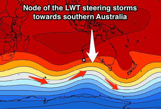
In fact, we're heading into an active period of swell activity across southern Australia as a strong node of the Long Wave Trough (LWT) moves in from the west later this week. The Long Wave Trough dictates the Southern Ocean storm track and intensity, and what we'll see is an initial strong low develop over the weekend (generating swell for Sunday/Monday), followed by a more significant polar frontal progression directed up towards the Great Australian Bight.
It's this secondary progression that organisers will be keeping a close eye on. The system will exhibit winds in the storm-force range, weakening slightly as it projects north-east through Margaret River's southern swell window.
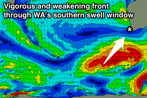 The result will be a large, long-period S/SW groundswell, arriving overnight Tuesday, peaking Wednesday - the first day of the waiting period - around 8ft across Main Break, with the odd bigger bomb.
The swell will ease off slowly through Thursday and Friday, with smaller surf expected through the middle of the waiting period as the LWT moves east under the continent.
A positive outcome of the LWT moving east is that a strong ridge of high pressure will slowly move in from the west, producing offshore E/SE winds each morning from Wednesday (giving way to afternoon sea breezes).
The weekend may see winds swing more NE favouring The Box, but the swell is looking on the smaller side of things at this early stage.
Later in the waiting period we may see another significant S/SW groundswell impacting the West Australian coast, but we'll continue to provide running updates in the comments section below.
Margaret River 16 Day Forecast
Margaret River WAMs
Margaret River Surfcam
Comments
Excellent. Hopefullys its 3 for 3 for the Aussie leg. I wanna see the pros do there thing at hells.
Cool bone man! I wanna see Hell at north Box.
I might even get to ride the same 10point wave from the box at Bells a few days later across in Victoria! it's kinda possible?
Many thanks, Craig. A question about the LWT if I may. Many of the low systems that track east beneath Australia have a wind flow that is quite easterly in orientation, so they generate little or no useful swell for the east coast. Others have a much more SW or even southerly orientation in wind direction that are much better for swell generation when they enter the swell window for the east coast. My question: Does the LWT have an important role in the wind direction of these systems, or is it primarily influential on how far north these systems track (or is the answer far more complex than this question suggests)? Thanks.
Great question.
Yes the shape and position of the LWT will influence how much swell will move up into the Tasman Sea.
If we have a drawn out less pronounced (flatter) node sitting over New Zealand, it will create more zonal storm activity (west to east) which hardly makes it into the Tasman Sea.
But if the node is more pronounced, and peaked over New Zealand, this will help steer the fronts more south-west to north-east, up through the Tasman Sea.
So it all depends on the shape of the node and its position.
More here: Long Wave Trough: The Waves That Create Waves
excellent. thanks craig
Do they still have a permit to run at North Point?
Yep.
Monday best chance or something later on ?
Contest doesn't start until Wednesday.
And yeah as below, swell not big enough and from the wrong direction.
The scaffold's already up. Swell's prolly not big enough for North Point from that direction.
Stu > as an aside r u going to do any analysis of YouTube/Facebook etc viewership from the Gold Coast event?
Got more of a broad overview, as opposed to a tight focus analysis, in the pipeline. Been helped along by some conversations with WSL sponsors.
gr8 thanks; look forward to whatever you do on the issue; its a fascinating time for the industry > from what I saw the attendances were massive - but imagine the $$$'s are all on the web and sponsorship? Personally I find the WSL's heat review and highlights system very clunky?
WSL Highlights: why cant they just show every scoring wave instead of those annoying promo,film clip type sales pitches they throw at us?
I wouldn't just solely be looking at the LWT for swell influence . I'd be keeping on eye on the Hurricane /Cyclone about to form off Madagascar and more importantly it's re entry into the southern Storm track . Timing and captured fetch another twist . And most likely to deliver any chance of a Northies session .
Have been keeping a close eye on this development Southey but with the system off Madagascar being so weak (more so just a tropical depression) it doesn't have much energy once it enters the Southern Ocean storm track and is swept away with no major impact.
How far out is that southey ?
Chowder ,
The access model I'm looking at says that the system will peak in Strength on Thursday / Friday and then move in a ESE direction possible smashing Reunion on the way to being picked up in the western storm track supported by the second node in Craig's image above . The other thing is another disturbance in the sub tropical Atlantic in the next few days . How long is the waiting period ?! The last big swell ( that I just missed ) was born out of similar circumstances . I'm thinking the cyclical 10-14 day pattern in place will deliver another , let's hope it's timing and sizing is generous ! My back of napkin estimate would have swell delivery at worst case April 4 th . Of it could just flounder under constant shit SSW swell .
Roger that southey .
Update: The outlook is pretty similar to above, with a large increase in SW swell for Sunday afternoon and Monday morning, while Wednesday's large S/SW groundswell is still on track (day 1 of the waiting period).
An easing trend will then be seen into the end of the week, slowed by a small to moderate sized S/SW groundswell later Friday and Saturday morning.
Beyond this there's nothing major showing on the charts at this stage, but there are a couple of swell sources for late in the period.
Wednesday: S/SW groundswell to 6-8ft, easing through the day. Light to moderate SE winds ahead of SW sea breezes.
Thursday: Easing S/SW groundswell from 4-6ft. Moderate SE winds, freshening from the S/SE through the day.
Friday: S/SW swell to 3ft to occasionally 4ft, with a new S/SW swell late. Moderate E/SE winds, with S/SW sea breezes.
Saturday: S/SW swell easing from 3-5ft. Light E/SE winds ahead of a shallow S/SW change.
Sunday: S/SW swell to 3ft+. Fresh and gusty S/SE winds.
Monday: Small SW swell to 2-3ft. Moderate to fresh SE winds.
Tuesday onwards: Small SW swells with favourable winds each morning.
It must suck to have to watch them take over north point when it's good .
fkn dimwits !
Southey, 18z the first to finally show some possible large swell from that tropical depression, but S/SW energy as it's absorbed into a polar low.
Also Wednesday/Thursday's S/SW groundswells are looking super tasty.
Not the best direction but the 8ft+ range, with S/SE winds Wednesday and straight offshores Thursday.
Craig, will this swell direction favour the lefts or rights any more so at Margs?
Looks like rights be good fri/sat Don weather. (Sw angle best )
Looks like John John is ready to rock and roll
Current Wednesday forecast:
Peak at 19.3 second period?
Is that secondary swell peak from the primary swell?
Are the models combining the two swells on Wed? ie overcooking it due to 2 SW swells in the water?
Okay that would make sense, the secondary swell has totally gone now.