Monster Nazare forecast

Later this week a swell is forecast to hit the European coastline that'll stretch the capabilities of the wave models. Rarely seen colours will appear on the WAMs owing to the storm's intensity, and much of the energy will be directed toward Nazare in Portugal. It'd be the perfect scenario for the biggest wave ever ridden, except for just one thing.
The swell will be the product of a low pressure system that formed yesterday off the US East Coast. The low is forecast to track east through the Atlantic Ocean while feeding off a deep cold pool in the upper atmosphere. Rather than being a garden variety low, two things will then occur that'll give this weather system special significance.

Firstly, the central pressure of the low will drop over 24hPa within a 24 hour period, classifying the storm as a 'bombing low'.
Secondly, the low will be cradled in an ocean-wide high pressure system located to the south. The bombing low will squeeze up against the broad high with the resultant pressure gradient creating an impressive fetch. The wind field will feature storm to hurricane-strength winds projected ideally towards the Portuguese coastline.

All good so far.
The swell is expected to hit on Thursday (local time) and peak that night. Late Thursday or early Friday will see the biggest sets, which, owing to Nazare's swell amplification ability, may see waves reach in excess of 80ft. Perhaps even nudging the 100ft mark. You can be sure that big wave surfers the world over are watching this one.
...and now for the bad news.
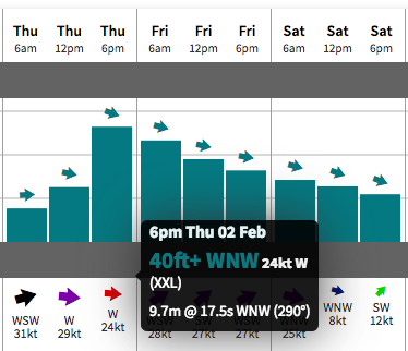 When the swell arrives late on Thursday a secondary frontal system is also forecast to push into the coast. Unfortunately, this will bring with it strong to gale-force onshore westerly winds that are expected to render the waves unsurfable. It's yet another case of 'what if' - when all the elements align except for one.
Despite the disappointment, online punters can take consolation in the inevitable flood of big, ugly Nazare shots on social media, Meanwhile, for local surfers every west-facing coast from Guinea to the Orkney Islands is about to be inundated with swell. Just gotta get out of the wind.
Back at Nazare, Saturday will remain very large but on the downwards trend as the onshore winds slowly ease, while Sunday will have good winds but a paltry(!) 20ft of swell.
Comments
Looks like Morocco might be the place to run too. Light variables maybe even offshore
Not Frothing. Faaaarrrkkk.
Oh well, saving $$$ that i dont have is a good thing.
Justine Duponts been getting a couple ...go girl.