The spectre of development looms over Gnaraloo and Red Bluff

 The owners of Western Australia's Gnaraloo and Quobba Stations, whose properties border two of Australia's best waves - Tombstones and Red Bluff - face an uncertain future. On June 30 this year all 507 of WA's pastoral leases will expire, and the Government has sent out 503 lease renewals. Gnaraloo and Quobba are among the four stations that haven't received renewals, the others being neighbouring stations. What happens after June 30 will decide what surfers will find when they make the seasonal run up to the north-west.
In 2004 the Western Australian State Government commissioned a report into land use in the state's north-west. The report proposed co-opting land that's currently held under pastoral leases and placing it in the hands of the state.
Despite being wrapped in bureaucratic red tape for over a decade no agreement has been reached with pastoral stations on the Ningaloo coast between Exmouth and Carnarvon. The uncertainty has loomed ominously over Paul Richardson, the owner of Gnaraloo Station. “That process has been a part of my life every day for the last 10 years,” says Richardson with resignation.
It's with good reason that Richardson has been concerned by the governments plans. He always suspected the findings would be used to justify a “land grab” and Richardson says his suspicions are coming to pass.
On June 30 this year every pastoral lease agreement in WA will expire. The State Government sent out lease renewals to over 500 leaseholders late last year but Richardson is yet to receive his. Likewise, the owners of neighbouring Ningaloo, Warroora, and Quobba Stations, all coastal stations on the Ningaloo coast, are yet to receive theirs.
For ten years Richardson has maintained Gnaraloo at zero cost to the Western Australian taxpayer. And the environment on the 220,000 acre station is in excellent condition. Amongst other examples, Richardson cites the monitoring, management, and protection of the largest mainland rookery for loggerhead sea turtles – an endangered species. The turtle work, and also work done under the Gnaraloo Feral Animal Control Program, is internally managed and paid for by Gnaraloo Station Trust.
Like the owners of the nearby stations, Richardson says his careful management is borne out of responsible stewardship. The result is a landscape very close to its natural state.
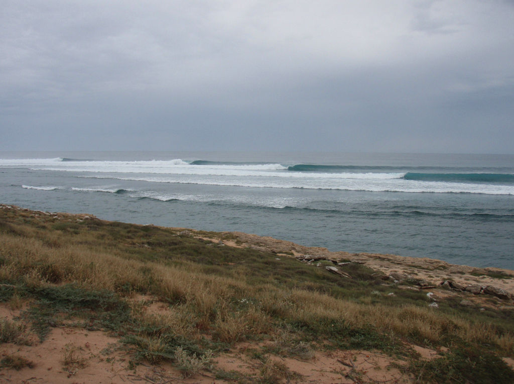
“When you come up here to surf it is a wilderness experience and adventure,” says Richardson. “What the Government has planned will change and ruin the very reason that people come here in the first place.”
What's on the table is a plan to hand the coastal land over to Government and turn undeveloped portions of the Gnaraloo coastline – land that is that is currently wilderness area - into tourism nodes catering to between 200 and 500 people per night.
In a recent interview with The West Australian, the manager of Ningaloo Station, Phil Kendrick, said Parks and Wildlife, "Want to do glamping development for ecotourism, which is just flavour of the month terminology for putting in $600-a-night tents to cater for the rich and famous.”
Paul Richardson is similarly cynical about developments such as eco-lodges which he says, “Often just amount to commercial tourism development dressed up as offering positive environmental outcomes, but which is more often just green spin.”
He also senses something far more sinister: the possibility of Government selling off or leasing portions of the coastal land to developers for commercial development.
“The Cape Range National Park employs about 40 people. What happens if the government decides they haven't got the funding to manage and adequately resource the extra land on the 260km long Ningaloo coast?” Richardson asks quizzically. He leaves the question hanging a while before answering himself.
“Well, they're going to have to sell portions of the land which will fall out of public ownership. Developers will move in and change this landscape forever. There will be no going back once those changes occur and wilderness assets will be lost for good.”
Richardson reinforces the point about how well the land is currently cared for and in so doing repeats a statement he made earlier, “What the Government has planned will ruin the very reason that people come here for.”
Swellnet has contacted Terry Redman, WA Minister for Regional Development but is yet to receive comment.
Comments
pay to stay in a cattle yard & surf crowded waves. Future Exclusive Cloudbreak of w.a. Strategy. The waves wont change but , just the people
Good point, could everyone please email these people, as instructed to me from Phillip, the caretaker of Ningaloo, who is in the exact same position as the guys from Red Bluff and Quobba to ensure the word gets out that no-one likes the idea of governments selling off epic land
Hon Colin Barnett, Premier of Western Australia
93831505
[email protected]
Ministerial office:
65525000
[email protected]
Minister for Lands, Terry Redman
65526700
[email protected]
Electoral office:
[email protected]
98481371 or 1800644811
Brendon Grylls MP [He is on our side]
1800199347 or 91444113
[email protected]
Hon Dr Nahan, Treasurer
65525700
[email protected]
Hon A.P Jacob, Minister for the Environment [and DPaW]
65525800
[email protected]
I've persuaded a stack load of people to complain already and i hope this helps even more
As far as the DPAW are concerned ,Ningaloo station have caused the most degredation to this once pristine piece coastline than all the other coastal stations . The ongoing farming of feral goats , a declared pest in WA is what has caused this degredation . Don't be fooled by Mr Kendricks rhetoric and scaremongering about $600 a night eco tents , he wants that land to continue the unsustainable practice of farming goats on
it's not going to happen . The whole coast will managed as a world heritage listing . Low key development with a large emphasis on environmental protection . There cant be room for goat herders who are destroying our coastline , it's time for a much needed change ! .
The goats on Ningaloo Station are the only way people like us can stay there for extremely cheap rates. Sure the goats do a little damage but a bulldozer does more. Have a look at the iconic Great Barrier Reef, there were some great "plans" to make the place better, but all it did was kill the reef. Now the only thing the Great Barrier is iconic for is dying. Ningaloo Station also contributes millions of dollars that go into the local businesses via tourists buying food, supplies, tours, water, tackle and repairs. If a resort supplies all of these, the local businesses aren't going to be the ones making the money anymore, it's going to be the billionaire just adding more money to his balance.
Sorry regan , but if you think about it these are very feeble excuses , goats do a little damage ? Are you serious ? ,Huge resorts destroying the reef and bankrupting local tackle shops and the like , who's been feeding you all of this ? The amount of damage caused to the environment by farmed feral goats makes Ningaloo station unviable to world heritage listed coastline . Dont worry too much, nothing will change as bad as you depict , you'll still have memories and photos to cling too .
The leases have not been renewed so the government can sell off the land to the highest bidder, any newspaper or worthy literary work will tell you that. Even if that is not the case and it moves under world heritage, nice little park benches, car parks, water fountains and the like is not what people want. We head up north to places like Red Bluff and Ningaloo to get away from all the cities influences, bringing those influences up with us defeats the purpose of going up there in the first place. "
Regan, do you mind me asking you which newspapers you read ,and do you believe everything you read in newspapers ?. You must try and take this idea of "SELL" out of your mind and vocabulary , and replace it with "Lease" . The pastoralists have wanted freehold for years , do think the government was going to give it to them ? . Apart from the cost do you have any complaints or issues with any of the camping grounds within Cape Range . Your deluded if you think every part of the coast wont be as it is now . A former senior DPAW employee ,recently told me that if it wasn't for Ningaloo and Exmouth stations Cape Range wouldn't be continuously reinfested with feral goats . This isn't good and reflects on the management practices allowing this to happen . The pastoral lands board cant get away with changing the LAA Land Administration act to suit leaseholders and give them immunity forever . Here's my utopian outcome , I have the "sceptre " and I'm booting a few leaseholders ass's down Gnaraloo track while praising Blowin and Southy chained up to bulldozers . Your mate cant even phone a friend .
A lot of money to be lost on the stations side also
65 sites not including overflow up the back on the ridge
Kids can't drive themselves so 2 adults and 2 kids on every site during school holidays
Say an extra 6 groups in the overflow = 71 total sites
$25 pn adult = $ 3,550
$15 pn kids = $2,130
$5,680 per night
Winter and October both booked out for 10 nights each school holiday period is $113k for a 4 week period
Would be a great shame to see the place all delux eco tents or small boutique luxury holiday houses for the rich pop up along the coastline
perfect scenerio for wa govt, mining companies, big pastoral firms and indigineous groups to show how a core group could come together to manage the animal/vegetation protection, small scaled eco tourism and the uniquenes of this type of adventure experience. get 4 corners/landline up there to raise awareness. once gone, she;s gone forever.
Fucked
the government can never let the environment get in the way of the almighty $$$$$ its a fken crime .
'Developers will move in and change this landscape forever.'
A statement that has been made once or twice during the last couple of hundred years in Australia, same problem different complainants.
.
This needs to be stopped. Places like Gnarloo and Quobba should be kept just the way they are accessible to everyone so long as you are willing to rough it a little.
Overdevelopment and exploitation of something that belong's to everyone is wrong.
if it wasn't for hardy surfers and rough fisherman going up with their mates or family men taking their kids up these places wouldn't be on the map. So now the WA state government want's to take this away from everyone so they can profit from a bunch of rich yuppies being able to stay their in luxury.
Another brilliant yarn Stu. Thanks for bringing this to the attention of the rest of Australia and the wider surfing community.
Colin Barnett truly is a blood sucking monster of a human.
This is depressing reading.
Follow the money. Who's set to benefit most out of this? I can assure you the 'environment' will be taking a back seat to all of this.
what can be done to stop it? how can Paul Richardson's case be furthered? in coming back to WA after 20 years living elsewhere the 1st thing I wanted to show my kids was surfing NW WA. they absolutely love it - we go to 3 mile camp every year. surfing in the wilderness is a whole different realm of surfing for me. I'd be more than willing to get behind a resistance campaign around that?
There's a petition here RR.
thanks stu . will pass on to mates too.
Wherever surfing goes, society follows..... Byron, goldy, sunny coast, Bali, Hawaii, Even cold water spots like Victoria's surf coast, Margaret River, and J bay are unrecognizable from 20 years ago.....
We go there, find waves, popularize the place, post photo's and make movies, use the waves in surf product advertising, then whinge when "they move in".....
The problem has been known about since 2004..... Hindsight is a wonderful thing... Perhaps when a similar scenario occurs in the future, and it will, a petition of some sort should be organised, for the said region to be considered a surfing reserve....
land values go up, rates go up, this is an old trickster from way back
Ain't that the truth! Grubby little surf towns get overtaken by pretentious celebrities and cashed up idiots with an identity crisis.
I am so sick of this shit, when do we ever learn not to spoil what makes this and every other place special.
.
coops70 the answer is ...never,not when money is involved.Sad but true.
once again we are held to ransom buy the all mighty red neck pollys who prob are from another country dont surf have no appreceation for our ancient land and coast line australians should hang ther heads in shame for we are a democracy so shouldnt our opinion count or is it just the fact that we are all still cociderd covicts and we will do what we are told by the face less criminals that work for the allmitey mortgage belt investers
Faark, just when you think things can,t get any worse for WA and then it does.
Anyone clued up on how crowdfunding works ? Let's all pitch in and buy the Bluff and tell the government to get their stinking hands off it.
A raffle system to determine who gets to stay ...for a voluntary donation only, no fees....month long blocks available. No rules or signs to continue in the NorWest tradition.
Please have an act - has worked for decades already.
Rubbish, shitters and bookings can be performed by volunteers to secure campsites.
No development. Fuck off the goats.
Dont know whats worse the greedy irish man been given it for another lease or the government taking it back. Since Paul took over the camp it has fallen into a state of disrepair and camping fees have gone to a ridiculous level. Don't know the truth behind the statement Paul has not had any taxpayer money to up keep the station and the turtles. Story goes he / has applied and been given numerous grants from the government to sqaunder. Might want to re ask him that question. The station and 3 mile are in more rundown state than ever. Cyclone probably best thing that could of happened up there. Pity it did not blow the whole thing away. Just another amazing spot that will be ruined by a greedy foreigner/ fat developer or our government,
Thank god someone calls it how it is ...Paul has not looked after the place that's why they want it taken !
Let's all remember is Paul doesnt own the place .. All he has is a Pastoral lease! .... when's the last time anyone saw a sheep ? makes all his money from tourism . He shouldn't be allowed to do that . I hate CALM like the rest of us but I'd love to see that prick gone
Those greedy foreigners mate, country's full of em, as for the Irish don't get me started heard he's only gona open a red rooster.
.
Never commented before but this pisses me off. Surfed Red Bluff regularly in early 80's when working on nearby Wyloo Station and it is a national treasure. The best use of the resource is agriculture and surfers willing to go rough.
Ok fellas lets look at it this way...been there a .handful of times despite lived in wa for 15 years.indo easier and lets face it up norths a mission.need a trailor for the export cans.and wwhat will you do when tombies is 8 foot.more cunts watching than surfing who will enforce cunts camping?
yeah the station owners can now relate to how the aboriginals must've felt when their land was taken from them.greedy foriegners!
how can we sleep while the beds are burning?
it belongs to them,lets give it back!
Hey troppo lets get midnight oil doing a film clip.kai neville and cunts get a can of backed beans in the camp fire beds are burning ya poofs
I guess its kind of inevitable that some form of increased development occurs up there. After all, the original introduction of the cabins at Gnaraloo is a form of increased development, which back in the day I imagine wouldn't have sat well with the original camp crew who traditionally roughed it at 3-mile, and still do (I too prefer that option!).
At the end of the day, if the place is developed or marketed to the high enders, I cant imagine the gov or any private owners successfully locking the keen regular crew out of there, no matter how hard they try. They would surely have to accommodate both options. You'd be sharing the line up with a few more people, and there'd probably be an increase in reef faceplants along with gumbies being choppered out of there.
Hey hopefully they put the insurance money to good use and redeveloped the place with some decent infrastructure ...but no dought it will go in Paul's pocket if he's even insured as I'm sure none of the infrastructure meets any australian building code. At least at he bluff they have made a concerted effort to improve the infrastructure as with anywhere the crowds increased every year....someone has dropped the ball here and now their alarmed that the state wants to take back ownership ...how about putting a constructive plan forward .YOU MIGHT EVEN FIND THE STATE GOVERNMENT WILL FUND IT .
Why does anyone one want improved infrastructure ? What's wrong with the way it is or with less infrastructure ?
Paul from Gnaraloo talks shit. Managing feral animals, what a load of garbage. He farms goats for fucks sake.
There is a sign on the Gnaraloo/ Quobba fence line on the turtles track describing the government funding to preserve the environment. He's just biding his time to BE the developer.
I guess my previous comment back up the top of thread was a poke at lack of maintenance.
Went up last year school holidays and in two of the dunny blocks only had one shitter working in each. Did a hit and run a few weeks later and one was still not fixed.
Not asking for more facilities, just make the ones that are there work
You never know, National parks got hold of it, left current camping unchanged, lowered the price, provided free fire wood, added a few park benches around the place, better toilet up the car park, couple of park benches up there and a bit of shade for your lady to sit under while she gets a few happy snaps of your surf for the family album. Wouldn't be the worst idea in the world, definetly not going to encourage any more people to head up there than already do
Well the place got totalled by the cyclone so what was there ( which is basic and in need of gentrification)has been totalled and he's crying poor and doesn't want to rebuild
In need of gentrification ? Are you sure you're on the right thread ? I'm pretty sure that the people on here are against the development and gentrification of the joint.
You want to be comfy , then there is a million resorts for you to drink you're Piña Coladas at.
Not that I mind a Piña Colada.
Love these two spots and how fairly pristine they still are. I suppose it relates to how aboriginal people feel!!!
Point is you gotta pay to play and if the gatekeepers aren't going to rebuild and provide adequate facilities for all then they should be stripped of their responsibilities ...no one is going to develope here they can't even fill the Novotel in Exmouth it's the west Aussies community that funds gnaraloo not the tourist dollar. And I'm sure anyone who's done regular time up here would know that the facilities at three mile haven't been ungraded in a decade and now there's no plans to fix it b4 the ever increasing crowds turn up
Bruce, you should stick to Busselton if you want facilities. That's the whole point.
Facilities = development.
You want toilet blocks with mirrors and tiles, cafés and a pub go somewhere else.
No tourists will go there ? You been to Coral Bay lately ?
Bruce you are fuckwit
I'm sure anyone who's done regular time up here would know that the facilities at three mile haven't been ungraded in a decade and now there's no plans to fix it b4 the ever increasing crowds turn up.
Bruce anyone who has spent regular time there doesn't give a shit about the facilities.
People commenting about average facility's provided are missing the point of what this will happen to the coast in the future.not about all the loos working.
At the moment you do not have to pay to play Bruce. you can drive in to surf all day drink beer in the car park then leave all for free.if you don't have heaps of coin you can normally come to some kind of arrangement to do some cleaning / rubbish duties for a free camp.
I don't see Paul crying poor in any of his statements?
All you people talking shit about Paul ,what you think the government is going to do a better job keeping the place as it? They have already stated that they want the coastal strip for tourist development 200/500 people nodes.
You say it hasen't been upgraded in a decade ,fucking good.you want it to become even more comfortable so more crowds turn up?mabey you and your family could stay home if it is to uncomfortable.
Fuck off.
You could have just used the fourth word and the last two words in your post.
As Whitney once said it's not right but it's ok, the latest development to another area that was pristine for 1000's of years until quite recently, no one batted an eyelid when the dunnys went in. Plus ca farkin change
I doubt anyone will develop it into glamping, maybe a few select sites that are already pretty much there, how many people do you think can afford those rates?
If you had to pay $600 a night where would you rather go. Gnaraloo where it's a barren shit hole and usually a bit cold, or the Mentawai's where the water is warm, the land is lush, green and tropical, and the accommodation is swank?
I would think the most likely thing to happen is it will end up like Cape Range, $10 a night and clean camp sites taken care of by volunteers.
And finally the pastoral lease holders knew this was coming, the Government (DER/DPAW) has planned to take back certain areas of the pastoral leases (wet lands, coastal areas, areas of significance) for years so really it's a bit late to have a cry.
stop the press gentlemen.just look at how the indo's developed ulu's!
i'm drawing up plans/proposals for a karaoke/nudie bar positioned rite on the point so u can crawl up the keyhole n be in true paradise.when crew arent drunken singing will have jack mckoys billabong challenge playing on the giant flat screen.big dance floor with facilities that work such as a water slide rite from the dunny's to the back of the lineup.
mite be a few more turtles floating around?.
skimpies send ur cv now!
if successful looking to franchise.if interested in being an investor send me your money!!!!!!!!!!!!!!
If your going to put a bar out on the point a water slide from the bar into the keyhole is a must!!!
This is heaps sad, I remember going through the 400 pages of proposal when the WA launched the pilot project at Red Bluff years ago. The pilot project resulted in the luxury tents destroying the bluffs scenic ridgeline. The "master plan" included the layout for a resort and accompanying shopping plaza. Heaps sad for Reed and Monique as well as Jimmy and his family.
On the other hand, I detest Paul, think he's a classic example of arrogant (SA) wanker. Would be awful to see Gnaraloo in State hands but honestly I'd see the dusty carpark he uses as a camping ground turned into a resort for the rich rather than staying in that cunts hands. He's a thief, a liar and reprehensible enough to completely decimate my etiquette and perspective of this issue.
If the state gov get hold of it next comes the WSL, make accom flash enough for the pro princess and watch the $ roll in
^^yep them then airport so the rich and pros can roll up just in time for swells
MTown , this is the first time I've completely agreed with anything you've posted .
Well said .
Zeph , agree in regards to Bluff .
A while back bluff was good for cost , and 3mile was over rated when the Japanese ( or whoever tried to do those stone houses at the station were involved ?!?
They need to keep different levels of facilities ( which coincidently is exactly what is there ) . Sexmouth for internationals , Oral bay for Perth mums and dads & backpackers , 3mile for the typical 1 week crew who have to brag to mates they surfed " tooomies " & a typical block of yallingup relocationers . Bluff for long term budget men , and crazy hard core lone internationals ( usually hitched in or floated Barinas' down the track ) .
And for those long termers that are setup to carry everything including water themselves the other two stations .
Regardless maybe simplicity is my favourite , and for that Bluff ( after fucking the tents off the top and hidden in valleys ) is the best template for that area . Jim and Phil before him are/were there for the right reasons . Reid and Monique have invested the most and risk losing . The more simple the better , the less infrastructure the better .
If they start talking up a through road or even grading it the whole way , that's the trigger point . And I challenge everyone to join me and blockade the fuckers if and when that comes to fruition .
Buzz staying lookout on the northern section , ( I once was forced to wait at Quobba for a week until the freshly graded road dried before going back in . Had to do a few trips back to Cuntofatown for beer supplies which kept vanishing ! )
The Bluffs been going down hill since Oggy left.
Southey wrote " And I challenge everyone to join me and blockade the fuckers if and when that comes to fruition ."
Don't you see what the "Murdia" does to protesters these days, southwald?
"Bludgers"!
"Rentacrowd"!
"Ferals"!
And of course you'll have a gaggle of "Scott Cam's" saying "what have YOU got against a bloke doing a hard days work?" lol
Sheepy ,
This is WA not East Coast . I'm pretty sure the people with the muscle will be the ones trying to stop the roads . The Chardonnay environmentalists are few and far between in WA let alone the NW . Perth can jump up and down all it likes , but with the locals not wanting it then whoever tries to go up there to enforce the state legislation will find how remote they are . Carnarvon will not want any more supplies up there because at the moment they are the hub . If it goes ahead they become a bypass town pretty quickly . Same but to far less extent Exmouth .
Be very worried, southey.... Very worried indeed...... There is more to this than meets the eye.... For every "muscle man on one side", there will be the invisible ones on the other.... I'd be checking out the Nationals Vincent Catania, mate..... Just a heads up..... ;)
Any word on how the NW Surfers Alliance has responded?
Quite ironic.... There's a Mentawai's retreat ad beside this article....
Colin Barnett has just tried to introduce a bill outlawing any kind of protesting in public also. i guess after his shark policy humiliation and the James Price point debacle he is planning ahead for the next cash grab/land sell off plans now the mining boom $ have slowed, "lets develop public lands "is the new agenda
Welcome to the new world order, Mike ;)
get them on an environmental issue, an intergenerational issue and a plan for proposed aboriginal employment and land management. Fuck a cyclones just gone thru there, get local member and local elders to put in claim that local aboriginal labour be used and a area plan of management can now be made up now to help mange future issues like this plus plan for study into how many people site can environmentally sustain- for fucks sake, wake up- lot cheaper to fix washed out dirt road than destroyed bitumen one.
Sheepy ,
So 20 Robinson St Canarvon is where everyone should vent their anger this winter .
Or just take a few garbage bags ( ala. Cactus's Ronnie gig ) , and just unload their trips effluent on his office door step on their way back down south .....
There in itself is literally a shit load of reasons why he would not want to fuck with a tradition in an area. That's barely changed since before he was born .
Apparently he won't be in his office , as judging by his photo he'll be neck deep at the donut shop ....
Here u go, all the info's in here, loopholes galore- just a quick read also-joking
Part one- one letter of objection especially with concerns about the Environmental Impact Assessment will cause long delays ensuring the proper use of land management utilising aboriginal involvement and education can be the only sensible outcome. Happy Reading, campers
Ningaloo coast regional strategy
1
• Western Australian Planning Commission •
2
Section one Regional strategy
3
• Western Australian Planning Commission •
4
1.1 Background 1.1.1 Introduction
Overview
The regional strategy is a 30 year strategic planning framework for the study area which:
• Defines a vision for the future.
• Provides an overview of the planning, regional, sustainability and environmental context.
• Identifies the guiding principles for the future.
• Contains the Regional land use plan, which identifies the regional land uses and access network.
• Contains the Coastal tourism framework for the Ningaloo coast.
• Outlines the Planning and environmental guidelines for sustainable tourism on the Ningaloo coast.
• Contains structure plans for Carnarvon and Exmouth and a settlement plan for Coral Bay.
• Outlines the immediate planning and development controls being implemented Ningaloo coast.
• Provides the basis for the preparation of the Ningaloo coast statement of planning policy 6.3.
Study area
The study area for the Ningaloo coast regional strategy Carnarvon to Exmouth lies within the Gascoyne Planning Region. The study area extends north from the town of Carnarvon to the Exmouth Gulf, includes all land west of the North West Coastal Highway, Exmouth Gulf and Murion islands and extends to the western seaward boundary of the proposed and existing marine park (figure 1).
Purpose
The Western Australian Planning Commission (WAPC) has prepared the Ningaloo coast regional strategy Carnarvon to Exmouth, following consideration of submissions received on the draft Carnarvon-Ningaloo coast regional strategy released in May 2004. The draft itself was largely based upon the discussion paper, Future directions: sustainable tourism and land use scenarios for the Carnarvon-Ningaloo coast (Future directions) in July 2003.
Term of reference
Review the Gascoyne coast regional strategy and incorporate the recommendations of other relevant planning documents, including the Exmouth-Learmonth (North West Cape) structure plan, relevant statements of planning policy and Hope for the future – the Western Australian state sustainability strategy.
Co-ordinate with other concurrent planning activities in the study area such as the Ningaloo Marine Park management plan, Cape Range National Park management plan, Ramsar listings as wetlands of international significance, and the state’s policy commitment to seek world heritage nomination.
Identify the most appropriate and sustainable long-term tourism and development options for the coast within the study area.
Identify and recommend the preferred vesting and management options for the conservation and recreation strip along the coast.
Prepare revised structure plans for Carnarvon and Exmouth.
Aquitial
Part 1
Coordination was undertaken with the other concurrent activities to ensure complimentary and integrated outcomes for the area.
Part 1, s1.2 and s1.3
Part 1, s3
Part 1, s2.1 and s2.2
5
• Western Australian Planning Commission •
Section one - Regional strategy
●
●
KIMBERLEY
PILBARA
GASCOYNE MID-WEST
GOLDFIELDS-ESPERANCE
WHEATBELT
Exmouth
SHIRE OF EXMOUTH
SHIRE OF CARNARVON
PERTH PEEL
INDIAN
OCEAN
SHIRE OF ASHBURTON
SOUTH-WEST GREAT SOUTHERN
Index to map area
Paraburdoo
SHIRE OF
MEEKATHARRA
Legend
local government
Coral Bay
Lake Macleod
SHIRE OF GASCOYNE
GASCOYNE
Carnarvon
Gascoyne Junction
SHIRE OF MURCHISON
Denham
N
0 50 Kilometres
SHIRE OF SHARK BAY
SHIRE OF NORTHAMPTON
Kalbarri
SHIRE OF CUE
Produced by project mapping section, planning information - mapping and spatial, Department for Planning and Infrastructure, on behalf of the Western Australian Planning Commission Perth WA August 2004 ntw-map5\ \strat_pol\reg_plan\carn_ning\ fpub04\study_area.dgn Local government boundary, cadastre and topographical data supplied by Department of Land Information, Western Australia
boundary region boundary
Onslow
Pannawonica
Cue
regional strategy area
road
6
COASTAL
HIGHWAY
WEST
River
●
●
●
●
River
River
COASTAL HIGHWAY
NORTH
WEST
ROAD
Sanford
River
●
●
Murchison
Figure 1: Study area
Gascoyne
MINILYA - EXMOUTH
Murchison
NORTH
●
●
Exmouth Gulf
Wooramel
River
River
Ashburton
Term of reference
Prepare settlement or site plans for Coral Bay and the future Blowholes tourism node.
Prepare environmental and planning guidelines for tourism development on the Ningaloo coast.
Prepare an implementation strategy to achieve sustainable outcomes for the study area.
Aquitial
Part 1, s2.3 and s1.2
Part 1, s1.3
Part 1, s3
The Ningaloo coast community stakeholder advisory group has prepared the following community vision:
"The [Ningaloo coast] is an internationally recognised sustainable (social, economic, environmental and spiritual) success, which combines the preservation of ecosystems with low-impact tourism. This is achieved through a management plan for conservation and public usage that is well funded, protected by legislation and supported through education and the wisdom of heritage."
The vision of the Ningaloo coast regional strategy has been carried forward from the Gascoyne coast regional strategy:
"To develop the [Ningaloo coast] into a tourism region of international significance focussing on its unique natural features. This would be achieved in a manner that is ecologically sustainable, retains the sense of wilderness and provides local and regional economic and social benefits. The development of existing and new industries which are complementary to this vision will be encouraged."
These visions reflect the environmental and cultural significance of the Ningaloo coast and the desire to see the coast managed sustainably. The priorities and principles of these visions are reflected in this strategy.
1.1.2 Planning framework
The Western Australian Planning Commission Act 1985 allows the Commission to prepare planning strategies for the state to co-ordinate and promote regional land use planning and land development, guide government departments, authorities and local government.
The land use planning system is fundamental to the achievement of community goals and
The preparation of the strategy was guided by a steering committee, reporting to the Western Australian Planning Commission, that was supported, as required, by a community stakeholder advisory group (community representation) and a technical advisory committee. The community stakeholder advisory group proposed a new vision for the Ningaloo region.
Vision
The State planning strategy outlined the following vision for the Gascoyne Region.
“In the next three decades, the Gascoyne Region will expand through increased development of tourism, horticulture, mining, fishing and aquaculture. The Shark Bay World Heritage Area, the Ningaloo Marine Park and Cape Range National Park, as well as the hinterland attractions of Mt Augustus and the Kennedy Ranges will be among the prime environmental tourism assets in the state. Aboriginal tourism experiences will also play a growing role in the development of tourism in the region. The region’s population will increase significantly as its economy grows, and major centres will develop. The region will achieve the highest standards of marine and terrestrial environment management and protection to ensure that its natural assets are well managed and, where necessary, protected.”
7
• Western Australian Planning Commission •
Section one - Regional strategy
aspirations. However, rather than drive these processes, its role is facilitative, ensuring land use and planning decisions improve the opportunities of the community to fulfil goals of creating wealth, caring for the environment and building sound communities.
The State planning strategy provides a strategic guide for land use planning to the year 2029 aimed at developing a land use planning system to help the state achieve key goals. These goals include generating wealth, conserving and enhancing the environment, and building vibrant and safe communities for the enjoyment of this and subsequent generations of Western Australians.
The principles set below come from the State planning strategy and should guide future decision-making throughout government through the strategies and actions for each principle. While each principle is unlikely to be met equally in each instance, the best outcome for the State’s future requires that proposals and plans address each principle fully.
State planning framework Environmental principle
To protect and enhance the key natural and cultural assets of the state and deliver to all Western Australians a high quality of life which is based on environmentally sustainable principles.
The pursuit of environmental strategies will contribute to a more sustainable future. The strategies are designed to:
• increasingly use energy sources which have minimal impact on the environment;
• prevent further loss in biodiversity;
• ensure that air, water and soil quality are protected and where necessary, improved;
• reduce consumption of materials and promote recycling;
• promote management and protection of resources;
• protect land and seascape;
• preserve public access;
• enhance the quality of life for all Western Australians; and
• and protect the state’s cultural heritage. STATE PLANNING STRATEGY
KEY PRINCIPLES
PRINCIPLES, STRATEGIES AND ACTIONS
• Protect the environment • Respond to social changes • Assist creation of regional wealth • Facilitate strategic development • Assist development of regional WA
ISSUES AND ACTIONS
• Southern Regions • Northern Regions • Central Regions
PLANS AND STRATEGIES
REGIONAL
• Statutory Planning Schemes • Regional Planning Strategies • Regional Development Strategies
LOCAL
• Town Planning Schemes • Local Strategies
THE PLANNING PROCESS
STRATEGIC FRAMEWORK
• State Planning Policies • State Land Use Coordination for
Resource Management • Review Planning Legislation • Strategic Emphasis to Planning
LOCAL
Incorporate Principles to secure; • Sustainable Development • A Sense of Community
8
Community principle
To respond to social changes and facilitate the creation of vibrant, accessible, safe and self- reliant communities.
To achieve this principle, strategies are designed to:
• monitor the amount and rate of population growth;
• respond to the changing needs of the population;
• improve the linkage between land use planning and the provision of human services;
• provide a range of housing
opportunities;
• build a sense of community through the design of accessible settlements and public facilities; and
• incorporate opportunities for consultation and include the views of local communities and groups with specific needs in local and regional plans.
Economic principle
Activity to assist in the creation of regional wealth, support the development of new industries and encourage economic activity in accordance with sustainable development principles.
To achieve this principle, strategies are designed to:
• provide flexibility in the planning system to meet the needs of small business;
• provide for the likely growth of downstream processing industries and value-adding industries; and
• make allowance for the needs of new industries and technologies and support the further development of State and Regional centres of business, culture and administration.
Infrastructure principle
To facilitate strategic development by ensuring land use, transport and public utilities mutually are supportive.
To achieve this principle, strategies are designed to:
• integrate land use and transport planning;
• provide efficient freight transport routes and hubs;
• plan for public transport and balanced travel;
• ensure the efficient, progressive
development and servicing of land;
• promote the development and optimal use of strategic infrastructure;
• support the development of major nodal urban settlements; and
• ensure that the provision of public utilities to country areas is based on economic and social considerations and promote public facilities as a means of assisting the creation of regional wealth and providing cultural benefits.
Regional development principle
To assist the development of regional Western Australia by taking into account the region’s special assets and accommodating the
• minimise delays in government individual requirements of each region. approval processes;
9
• Western Australian Planning Commission •
Section one - Regional strategy
The State planning strategy identified a broad regional vision statement and the key planning priorities for each of the state’s 10 planning regions, including the Gascoyne Region, which provides the focus for integrated planning to enhance the future prospects of each region.
A strategic planning approach with the use of guiding principles and the preparation of broad strategic plans and policies provides guidance for detailed actions at a local level.
Planning priorities for the Ningaloo coast region from the State planning strategy
The following priorities are identified in the State planning strategy to be implemented in the future development for the Ningaloo coast.
The regional planning strategy is to be kept current and updated as required for the Ningaloo [Gascoyne] coast to:
• provide a broad framework for land use planning;
• guide tourism, economic and urban development; and
• guide the management of environmental areas.
Area development strategies or structure plans for specific issue areas required in Gascoyne Region to be prepared to:
• provide integrated multi-disciplinary land use development plans addressing issues of competing demands;
• facilitate the sustainable development of natural resources; and
• coordinate the provision of strategic infrastructure.
The State planning strategy recommended that significant natural and environmental areas in the region be protected and infrastructure
requirements be satisfied through the following requirements for future planning:
• incorporate CALM management strategies into future regional planning and development initiatives;
• review management plans for tourist areas to protect them from future degradation;
• promote environmentally responsible tourist operations;
• provide water and sewerage services to tourist centres, especially Coral Bay; and
• implement transport initiatives such as the Gascoyne regional transport strategy.
Previous studies
As the Ningaloo coast has grown in tourism popularity in recent times, more attention has been directed to the area by government at all levels. The core planning and other related documents that have been reviewed to provide a context for the development of this strategy are listed below. A complete list of all documents referenced is provided in the Reading list. This strategy supersedes all previous strategic planning documents where there is any inconsistency.
Statutory planning documents
• State coastal planning statement of planning policy 2.6.
• Shire of Carnarvon town planning scheme 10.
• Shire of Carnarvon town planning scheme 11.
• Shire of Exmouth town planning scheme 3.
Strategic planning studies
• Coasts WA: better integration - the Western Australian Government's response to the Coastal taskforce report.
• Coral Bay settlement plan 1998.
10
• Coral Bay planning strategy. • Coral Bay taskforce report on
Infrastructure requirements for Coral Bay.
• Exmouth coastal strategy 1992.
• Exmouth-Learmonth (North West Cape) structure plan.
• Exmouth structure plan 1988.
• Gascoyne coast regional strategy.
• Guidelines for tourism development on the North West Cape.
• Draft Carnarvon coastal strategy. Other studies
• Hope for the future - The Western Australian state sustainability strategy.
• State Government Squatter Policy.
• A 12-Month survey of recreational fishing in the Gascoyne Bioregion of Western Australia during 1998-99.
• Draft fisheries environmental management plan for the Gascoyne region.
• Gascoyne regional transport strategy. • Roads 2020 regional road development
strategy – Gascoyne.
• First report of the Legislative Council Select Committee on Cape Range National Park and Ningaloo Marine Park.
• Cape Range National Park management plan 1987-1997.
• A representative marine reserve system for Western Australia.
• Ningaloo Marine Park management plan 1989-1999.
• Ningaloo Marine Park (Commonwealth Waters) management plan.
• Jurabi and Bundegi coastal parks, and Muiron islands management plan 1999- 2009.
• Exmouth Gulf coastal plan.
• Environmental Protection Authority report and recommendation on the proposed Coral Coast Resort at Mauds Landing.
• EPA Cape Range position statement 1. • North West Cape Wilderness Lodge
proposal (reference file).
• Designing tourism naturally - A review of world best practice in wilderness lodges and tented safari camps.
• North West Cape tourism development study.
1.1.3 Guiding principles for the future of the Ningaloo coast
The following guiding principles will be used to assess all future planning and development on the Ningaloo coast to ensure the protection and sustainable use of the environment for future generations.
1. Sustainable development
All planning and development must meet the needs of current and future generations through appropriate land use and planning policies and practices which integrate environmental protection, social advancement and economic prosperity in the interests of sustainable development.
2. Community aspirations
Future planning and decision making must be consistent with the vision for the Ningaloo coast, including equity of access for a range of visitor experiences in different settings for all people from those seeking a remote and natural experience along the coast to the infrastructure and services provided for in the towns of Carnarvon and Exmouth.
11
• Western Australian Planning Commission •
Section one - Regional strategy
3. Aboriginal heritage
All planning and development must provide for the ongoing protection of Aboriginal heritage if there are direct impacts, especially relating to the marine environment, and the continuation of Aboriginal use and caring for country. Where relevant, it should also provide opportunity for the development of culturally appropriate tourism though the interpretation of Aboriginal heritage.
4. Economic development
All planning and development should actively assist in the creation of regional wealth, support the development of new industries and encourage economic activity as long as these activities are in accordance with sustainable development principles. Planning and development must also support the provision and maintenance of infrastructure based on sustainability principles to service regional communities and develop and upgrade tourism infrastructure to improve the attractiveness of the region as a natural and remote place both to visitors and residents alike.
5. Interdependence
Development must not significantly interfere with current natural ecological processes. Ecological processes include physical and biological systems, which are interconnected strongly. Changing one part of the environment may have an impact on other parts.
6. Limits of acceptable change
Development must be within limits of acceptable change. The limits of acceptable change are defined as the degree of change a system can accommodate or buffer while still sustaining or returning to its desired characteristics. The limits may be defined by environmental, social or economic concerns.
What is acceptable or appropriate is determined by consultation with governments and communities, as well as by legislation and regulations. The limits of acceptable change establish the maximum level of alteration for a resource that society is prepared to accept. Given the region’s acknowledged fragile nature, more reliance on scientific knowledge and research will be necessary in defining appropriate limits of acceptable environmental change for this region.
7. Precautionary principle
Where there are threats of serious or irreversible environmental damage, lack of full scientific certainty should not be used as a reason to postpone measures to prevent environmental degradation. In applying this principle in planning and development, the following steps must be followed.
• The onus is on any proponent to show that development does not pose any likelihood of serious or irreversible harm of the environment.
• If the proponent cannot demonstrate there is no likelihood of such harm, the onus is on the development proponent to show that the harm can be managed.
• If the proponent cannot demonstrate the harm will be managed, the development should not go ahead.
8. Cumulative impacts
All planning and development must consider its cumulative impact. The demand for and subsequent provision of tourism or recreational development along the coast may result in cumulative impacts as each new development proposal is added to existing development. The ad hoc establishment of developments along the coast has the potential to erode the remote and environmental values of the area over time and also may affect the economic viability of the individual development projects. If there is an unacceptable cumulative impact, the development should not go ahead.
12
9. Protection of high- conservation values
Planning must be based on the protection of high-conservation areas such as the Ningaloo Marine Park, Cape Range National Park and surrounds. These areas are rare and irreplaceable natural assets with outstanding scenic, recreational and scientific value, which have been identified as a potential world heritage area. Development must not adversely interfere with these values.
10. Protection of remoteness values
Remoteness is a dynamic concept, rather than a static one. It varies from place to place, through time as society’s values change, and from person to person, therefore it is useful to describe remoteness in terms of relative values, rather than providing a definition. The Planning and environmental guidelines for future tourism development on the Ningaloo coast address specific issues which may affect remoteness values, for example emission of noise (eg power generation, vehicles and boats), light, smoke or dust, waste disposal (eg refuse disposal site, public toilets, evaporation ponds and pipe outfalls), visual impact (eg buildings and roads) or odour (eg sewage treatment). Development must not significantly interfere with any identified remote values.
11. Protection of biodiversity
Biodiversity underpins the processes that make life possible. Healthy ecosystems are necessary to maintain and regulate atmospheric quality, climate, fresh water, marine productivity, soil formation, cycling of nutrients, and waste disposal. Biodiversity is intrinsic to values such as beauty and tranquility. Australians place a high value on
native plants and animals, which contribute to a sense of cultural identity, spiritual enrichment and recreation. Biodiversity is central to the cultures of Aboriginal and Torres Strait Islander peoples. Australian plants and animals attract tourists and provide food, medicines, energy and building materials. Our biodiversity is a reservoir of resources that remains relatively untapped. Planning must consider biodiversity, and development must not significantly interfere with the biodiversity in a particular area.
Sustainability
At the state planning level, planning initiatives have been developed in
response to particular state-level issues. The most recent being the government’s response to an increased global awareness and commitment to encourage sustainable development.
Hope for the future: The Western Australian state sustainability strategy (state sustainability strategy,
November 2003) aims to coordinate development across the state, in accordance with the principles of sustainability. It provides a long-term agenda for the ongoing global goal of protecting the environment and raising the quality of life of all citizens.
Sustainability is defined in the strategy as:
“Meeting the needs of current and future generations through an integration of environmental protection, social advancement and economic prosperity.”
The State sustainability strategy provides the benchmark for decisions to be made by government and its agencies. The Ningaloo coast regional strategy Carnarvon to Exmouth sets a benchmark for future strategic land use planning by incorporating the principles of sustainable development, identified below, and aims to assist local governments in their 13
• Western Australian Planning Commission •
Section one - Regional strategy
interpretation and integration of these ideas within the context of regional Western Australia.
The preparation and release of the Ningaloo coast regional strategy Carnarvon to Exmouth achieves one of the identified actions of the State sustainability strategy, which is to:
“Complete the [Ningaloo coastal] regional strategy to define the location and character of preferred development and use of the coast in the context of the proposed world heritage nomination. Ensure adequate planning and development controls are established to implement the outcomes of the strategy.”
The strategy recommends the use of statements of planning policy to coordinate the actions of local governments, regional councils and state natural resource management agencies on priority natural resource issues. Also in line with the State sustainability strategy is the introduction of the Ningaloo coast statement of planning policy 6.3.
Sustainability foundation principles
The State sustainability strategy recognises the following as foundation principles for sustainability.
Long-term economic health
Sustainability recognises the needs of current and future generations for long-term economic health, innovation, diversity and productivity of the Earth.
Equity and human rights
Sustainability recognises that an environment needs to be created where all people can express their full potential and lead productive lives and that significant gaps in sufficiency, safety and opportunity endanger the Earth.
Biodiversity and ecological integrity
Sustainability recognises that all life has intrinsic value, is interconnected and that biodiversity and ecological integrity are part of the irreplaceable life-support systems upon which the Earth depends.
Settlement efficiency and quality of life
Sustainability recognises that settlements need to reduce their ecological footprint (ie less material and energy demands and reduction in waste), while they simultaneously improve their quality of life (health, housing, employment, community).
Community, regions, “sense of place” and heritage
Sustainability recognises the significance and diversity of community and regions for the management of the Earth, and the critical importance of ”sense of place” and heritage (buildings, townscapes, landscapes and culture) in any plans for the future.
Net benefit from development
Sustainability means that all development, and particularly development involving extraction of non-renewable resources, should strive to provide net environmental, social and economic benefit for future generations.
Common good from planning
Sustainability recognises that planning for the common good requires equitable distribution of public resources (like air, water and open space) so that ecosystem functions are maintained and a shared resource is available to all.
The principle of community can be used as an example of the integration of sustainability principles in the Ningaloo coast regional strategy Carnarvon to Exmouth. Community recognises the significance and diversity of
14
community and regions for the management of the Earth, and the critical importance of sense of place and heritage (buildings, townscapes, landscapes and culture). The structure plans for Carnarvon and Exmouth, the Coral Bay settlement plan and the Coastal tourism framework incorporate the local and regional diversity of places, through recognising the historical land use of areas and aiming to retain the sense of place.
Process Principles
Accountability, transparency and engagement
Sustainability recognises that people should have access to information on sustainability issues, that institutions should have triple bottom line accountability, that regular sustainability audits of programs and policies should be conducted, and that public engagement lies at the heart of all sustainability principles.
Precaution
Sustainability requires caution, avoiding poorly understood risks of serious or irreversible damage to environmental, economic and social capital, designing for surprise and managing for adaptation.
Hope, vision, symbolic and iterative change
Sustainability recognises that applying these principles as part of a broad strategic vision for the Earth can generate hope for the future, and thus it will involve change as part of successive steps which will continue over generations.
Measuring a more sustainable future
The State sustainability strategy identifies the need to develop indicators of change, which can be measured. These measurable
indicators can be used to monitor whether the principles of sustainability are working for the region.
Change indicators will be developed through consultation to monitor the sustainability outcomes of the strategy.
1.1.4
Regional context
The study area is located within the Gascoyne Planning Region. Within the study area are the significant centers of Carnarvon and Exmouth, as well as the tourist settlement of Coral Bay. The area is north of Shark Bay (a world heritage area), and includes Ningaloo Marine Park and Cape Range National Park (both important conservation and tourism areas). To the east, Karijini National Park (another major tourism and recreation attraction) and the Mount Augustus and Kennedy Ranges National Parks are part of a region that has an important future in tourism.
Regional economic drivers
The Gascoyne Region has a diverse economic base with the primary activities of tourism, horticulture, fishing, aquaculture, pastoralism and mining. Given the abundance of natural features, tourism is the largest and fastest- growing sector of the regional economy. Pastoralism as the region’s traditional economic base, now represents a declining proportion of the region’s economic base. Within the towns additional economic wealth has been generated from, fishing and horticulture in Carnarvon, and fishing and the maintenance of Australian Government defence communications infrastructure in Exmouth.
There are great opportunities for synergies to be developed between the Carnarvon coastal area, Shark Bay, Exmouth and the Pilbara Region to form a tourism package that will
15
• Western Australian Planning Commission •
Section one - Regional strategy
attract many more local, interstate and overseas visitors. It is important to ensure that the attraction of the combined region is managed to sustain the values that bring people to it.
The study area supports the towns of Carnarvon and Exmouth and a tourism settlement at Coral Bay. There also is a range of other permanent and temporary settlements, including a squatter settlement at Point Quobba (Blowholes), the salt and gypsum operation at Lake MacLeod, an airforce base at Learmonth, pastoral homesteads, fishing and numerous ad hoc camping areas.
The majority of the study area is held in pastoral lease and includes a portion or the whole of the following pastoral stations: Boolathana, Boologooro, Brickhouse, Bullara, Cardabia, Exmouth Gulf, Giralia, Gnaraloo, Marrilla, Mia Mia, Minilya, Ningaloo, Quobba, Warroora and Winning.
Agriculture in the Gascoyne Region
The agriculture sector was valued at $51.3 million in the 1999/2000 season and was dominated by horticultural and pastoral production. A well-established horticultural industry, located in the region's major service centre of Carnarvon, supplies fruit and vegetables for the domestic and export markets.
Pastoral stations represent more than just an industry to the people of the Gascoyne, but a way of life chosen by a distinctive group of residents. A total of 115 800 km2 of the Gascoyne land mass is allocated to pastoral activity. Wool and meat production are the primary activities, however many stations are diversifying to take advantage of opportunities in goat domestication, horticulture, inland aquaculture and outback tourism.
Mining
In 1999/2000 mining production was valued at $70.8 million, of which salt production accounted for $50.2 million and gypsum $20.3 million. The region contributed 27 per cent of the total value of Western Australia's salt production and 88 per cent of gypsum.
Fishing and aquaculture
In the 1999/2000 season, the Gascoyne Region's fishing catch was 5805 tonnes with an estimated value of $73 million. The catch is dominated by prawns, with the Gascoyne Region having the largest prawn catch in Western Australia.
The fishing industry continues to be one of the Gascoyne Region’s major industries. Prawns, molluscs, lobster, crabs and a variety of wetline fish are caught in Gascoyne waters, and processed at onshore operations at Carnarvon, Exmouth and Shark Bay.
Aquaculture opportunities abound in the region, and this industry will become more significant in the future, especially in the Exmouth Gulf area.
Tourism
In recent years (most recent available data), the growing tourism sector has become the major component of the regional economy. More than 200 000 tourists have visited the Gascoyne Region each year since 1996. A record number of 280 000 domestic visitors were reported in 1999, contributing an estimated $72 million to the local economy and significant additional amounts to the State economy.
Significant centres Carnarvon
Carnarvon is the largest town in the Gascoyne Region. It is an important regional centre and a gateway to the region and the study area. It is the regional administrative centre and
16
Table 1: Population projections
Currently the population of Exmouth represents approximately 78 per cent of the total Shire of Exmouth.
Coral Bay
Coral Bay is an important tourism settlement comprising two caravan parks, a hotel, 26 holiday homes and ancillary commercial/retail uses. It has limited health services and no education services. Currently, Coral Bay has fewer than 1850 approved overnight visitor beds, though anecdotal evidence shows that this number has been exceeded during peak periods for a number of years.
An important aspect of Coral Bay is the fact that although there are at least 150 residents, made up of workers and business owners, during the busier part of the year, there is no provision for permanent residents within the settlement. The current accommodation facilities for workers in Coral Bay are sub- standard and a matter of concern. Work is under
way to ensure that leased land for workers’ accommodation will be available once sewerage is connected.
The Shire of Carnarvon has planning control over Coral Bay. The state government recommended as part of the preparation of the Coral Bay taskforce report on infrastructure requirements for Coral Bay (December 1996) that a moratorium be placed on development at Coral Bay due to environmental degradation and unsuitability of infrastructure services within Coral Bay. This moratorium remains in effect until land is connected to a public water supply and public effluent disposal facility.
The Coral Bay taskforce report recommended that the settlement remain as a tourism node and not become a conventional town. The revised settlement plan for Coral Bay,
Year Shire of Carnarvon
Shire of Exmouth
2001 6300 2300
2006 6500 2500
2011 7000 2700
2016 7500 2900
Source: Western Australian Planning Commission (2000b) Western Australia Tomorrow: Population Projections for the Statistical Divisions, Planning Regions and Local Government Areas of Western Australia.
provides a wide range of services and facilities. During winter the Shire of Carnarvon experiences an influx of tourists and seasonal workers. The 2001 Census population of Carnarvon was 7272, of which 1727 were visitors. The estimated resident population as calculated by the Australian Bureau of Statistics (ABS), for the Shire of Carnarvon in 2001 was 6723. This figure is well above the projected population for 2001, as shown in table 1.
Currently the population of Carnarvon represents approximately 83 per cent of the total Shire of Carnarvon.
Exmouth
Exmouth is the only townsite on the North West Cape and the second-largest town in the Gascoyne Region. Exmouth services the north of the study area and provides basic services, including education (kindergarten to year 12) and health care. In 2001, it had an estimated population of 1815. This increases to more than 3000 when visitors are included during peak times (Australian Bureau of Statistics, 2001). The estimated resident population as calculated by the ABS, for the Shire of Exmouth in 2001 was 2306. This figure is just above the projected population for 2001, as shown in table 1.
17
• Western Australian Planning Commission •
Section one - Regional strategy
contained in this strategy, provides a series of criteria upon which land should be developed, including the resolution of servicing constraints, environmental issues, access issues and infrastructure contributions.
Mauds Landing
Mauds Landing is located north of Coral Bay and is subject to many environmental limitations, including storm surge and cyclonic storm and rainfall events. It is adjacent to significant marine habitat and also has terrestrial values which were recognised in two decisions to reject development at the site. As a consequence of these limitations, the area has been recognised as unsuitable for any permanent development. The State has commenced processes to degazette the North Mauds Landing townsite and reserve the area for conservation and recreation.
Coastal tourism framework nodes
The study area contains a squatter shack settlement known as the Blowholes at Point Quobba. These shacks are on reserved land vested in the Shire of Carnarvon and are located approximately 50 km north-west of Carnarvon.
Formalised camping and accommodation facilities are provided at the following sites: Quobba Homestead, Red Bluff, Three Mile Camp, Gnaraloo Homestead, Warroora Homestead, Giralia Homestead, Yardie Caravan Park and Vlamingh Head.
There are many other places along the coast where recreational attractions including windsurfing, surfing, camping, snorkelling and fishing can be enjoyed. These places require some form of management to ensure their attractive qualities are retained.
Access network
The roads within the study area are part of either the primary access network or the coastal access network.
Primary access network
The primary access network within the study area consists of the North West Coastal Highway, Minilya - Exmouth Road, Burkett Road and Coral Bay Road. Main Roads WA is the owner and manager of these roads. All of the primary access network roads are sealed and designed to allow safe, high-speed travel.
North West Coastal Highway
North West Coastal Highway is the major state access, freight and tourism distributor route servicing the north-west. The highway provides access to the study area from Perth and Geraldton in the south, and Karratha and Port Hedland in the north. The road also connects the study area to the Shark Bay world heritage area, Ningaloo Marine Park and Karijini National Park. Access to the southern portion of the study area, including the Blowholes, and Quobba and Gnaraloo stations is provided from the highway via the Blowholes Road.
Minilya - Exmouth Road
Minilya - Exmouth Road serves as a feeder road from the highway predominantly for tourism and service traffic to Coral Bay, Exmouth and the northern portion of the study area. Some freight emanating from the pastoral and fishing industries use the road. Access is also provided to Warroora and Ningaloo stations from this road.
Coral Bay Road
Coral Bay Road provides access to the tourism facilities at Coral Bay and is used almost exclusively for tourism related activity. Access also is provided to Cardabia Station and the coastal access network north to Ningaloo Station and Yardie Creek.
18
Burkett Road
Burkett Road is an east-west link between the two major north-south freight/service routes. It also is a major tourism road providing a link to the Pilbara.
The primary access network is providing adequate primary access to the study area at present. Planned upgrading of the network by Main Roads WA to reduce the level of road closures (Lyndon River Crossing, Minilya - Exmouth Road) and widening sections to meet traffic growth and composition (North West Coastal Highway, Gascoyne River to Blowholes and Minilya - Exmouth Road) will ensure the network continues to fulfil its function.
The upgrading of the primary access network, outlined in this document, continues to be supported by the strategy. These roads may require pavement widening to ensure that they fulfil their function. This strategy does not promote additional modifications to the primary access network.
Coastal access network
The main coastal access network provides direct access to the coastal area and the majority of pastoral stations within the study area. The standard of road varies from sealed road to sandy tracks, which predominantly are the responsibility of local government. The roads in the coastal access network are classified as follows:
Track
An unconstructed and unformed road, essentially a track made by four-wheel drives and other large vehicles, created by force. Local government does not maintain them, but is generally aware of their existence as they usually represent a gap between sections of formed roads.
Type 1 – Unformed road
These are cleared, flat-bladed roads, with minimum construction, and usually are
formed from in-situ or adjacent material. Two- wheel drives can use them but only at low speeds.
Type 2 – Formed road
A type 2 road is formed and has drainage, without imported material and/or a constructed surface. This includes roads with intermittent sheeting.
Type 3 – Gravel road
A road that is paved and constructed from imported material (such as gravel) of adequate thickness, that’s compacted, shaped and drained.
Type 4 – Sealed road
These are constructed roads with a sealed surface but without kerbing.
The following describes the form and function of each of the sections of the coastal access network.
North West Coastal Highway - Blowholes
The Blowholes Road is a good-quality type 4 sealed road providing access for tourists and local residents to the southern coastal section of the study area and servicing the Dampier Salt operation. The key features serviced by this road include Boolathana Station, The Blowholes, Blowholes tourism node and the coastal road north.
Blowholes to Gnaraloo
Gnaraloo Road is an unsealed road running parallel with the coast. The road is type 2 (formed road) standard between the Blowholes and Quobba and drops to a two- lane type 1 (unformed) road between Quobba and Gnaraloo Bay. The road provides access to Quobba and Gnaraloo homesteads, HMAS Sydney Memorial, Cape Cuvier salt and gypsum-loading facilities, Red Bluff, Gnaraloo, Three Mile Camp and various recreation and camping sites along the coast.
19
• Western Australian Planning Commission •
Section one - Regional strategy
20
Gnaraloo to Warroora
The Gnaraloo to Warroora section exists as a track, which currently is closed to the general public from Gnaraloo Bay to The Cove and is not shown on the Regional land use plan (figure 4). This access is to remain closed making the area a remote coastal sector and an area of environmental management priority. The main Warroora station access road is from the Minilya - Exmouth Road.
Warroora to Coral Bay
The Warroora to Coral Bay section comprises a network of poorly defined station tracks, including coastal access tracks, not suitable for two-wheel drive vehicles. This main access between Warroora and Coral Bay is via the northern station access road connecting to the Minilya - Exmouth Road.
The tracks are subject to restrictions on usage. Camping areas accessible via the existing tracks include Stevens Camp, Maggies, Elles Camp, Fourteen Mile Camp and Point Anderson. The tracks provide the only access to the coastal features in this area.
Coral Bay to Ningaloo
This track is considered a flat-bladed track of a slow two-wheel drive standard is a flat- bladed track standard, with the exception of the sandy blowouts. It provides a coastal access to Ningaloo Road, The Lagoon, Oyster Bridge and Bruboodjoo.
Ningaloo to Yardie Creek
The Ningaloo to Yardie Creek Road while a local government road (Shire of Exmouth) is a flat-bladed track standard, mostly accessible by two-wheel drive vehicles to Winderabandi. The area from Winderabandi to Yardie Creek is predominately four-wheel drive access with the samphire flat areas and Yardie Creek Crossing sometimes becoming impassable after rain. It currently does not follow the road reserve and the reserve status within Australian Government land requires definitive resolution. There are a number of
indiscriminate tracks and minor detours being created, possibly due to sandy or inundated sections. The road provides access to a number of locations along the coast, including Ningaloo Homestead (main access via the east-west Ningaloo Road), Norwegian Bay, Winderabandi, Lefroy Bay and Yardie Creek.
Ningaloo to Minilya - Exmouth Road
Ningaloo Road is managed by the Shire of Exmouth and is an important access road to the coast and Ningaloo Station. It is a type 3 gravel road and provides good access to Ningaloo Station. It is used to service the station and by tourists wishing to access coastal areas between Ningaloo and Yardie Creek.
Recreational use of roads
Various reports have highlighted the need for improved coastal access based on research and analysis undertaken during their preparation.
During the development of this strategy, a number of issues have also highlighted the need for improved and managed coastal access.
There are growing numbers of people visiting the Ningaloo coast. This is evidenced by the increase in accommodation being provided at the more formalised sites (the capacity of Red Bluff increased from 30 in 1988 to a current peak capacity of 200). The tourism season is being extended into the summer months, as a result of international tourists wishing to visit the region year round. The operators of the various formalised facilities are planning modest expansion, resources allowing, as a result of the continuing growth. This continued growth relates directly to an increased need to provide better planned access.
Definitive traffic data to support the increasing visitor trend along the coast is difficult to obtain. However, figures obtained from Main Roads WA indicate that the Minilya - Exmouth Road had an average daily traffic count of 200
vehicles in 1998 to 1999, an increase from 1988 to 1989 of about 38 per cent or approximately 3.8 per cent increase per year.
Consequences of increased recreational use
Given the general increase in accommodation and the traffic growth being experienced on the primary access network, it is evident that the existing coastal access network is under increasing pressure.
As described in the Coastal access network section, there are parts of the existing coastal access network able to support this increased usage adequately without
any direct detriment to the environment (Blowholes Road, Quobba to Gnaraloo).
However the sections of coastal access network unable to support the increased usage, due to inappropriate location and standard, may cause detrimental impacts on the environment. These impacts may be addressed initially as ad hoc realignments, including severely corrugated sections of road, created to gain access around boggy sections or low-lying inundated areas.
Secondary impacts, such as indiscriminate access to a new location or expansion of an existing site, may result from the existing lack of management of tracks. The creation of a new camping site in an inappropriate location has the potential to create even more environmental degradation through the ad hoc creation of additional tracks.
Other considerations in the provision and upgrading of road infrastructure
Environmental Protection Act 1986
Any new infrastructure proposals will need to be referred to the Environmental Protection Authority (EPA) for consideration under the Environmental Protection Act 1986. This includes upgrading of existing roads, and any proposal for a coastal road between Gnaraloo and Warroora stations. A new coastal access network in this locality would require referral to the EPA.
Hope for the future: The Western Australian state sustainability strategy, 2003
The strategy highlights the need for integrated land use and transport planning so that the land use function drives the transport requirements and not vice versa. The Ningaloo coast regional
strategy Carnarvon to Exmouth and the associated Coastal tourism framework will guide land use and development within the study area and any improvements to the coastal access network will be implemented incrementally or the status quo maintained in response to changing transport demand.
Aboriginal heritage
The archaeological record of the Cape Range peninsula is significant in that it provides the earliest confirmed evidence of Pleistocene marine resource use in Australia. Aboriginal habitation of the North West Cape and Exmouth area is thought to have commenced at least 32 000 years (with some reports of 38 000 years) before the present and continues up to the present. The North West Cape area is an area of ongoing cultural 21
• Western Australian Planning Commission •
Section one - Regional strategy
significance to Aboriginal people and to the members of the Gnulli native title claimants group.
Gnulli means “All of Us” and the claim group includes the traditional owners of the Exmouth Gulf and surrounding area, including members of the Thalanji, Baiyungu and Ingarrda groups. The Gnulli group are recognised by the Aboriginal community as custodians of Aboriginal culture for the Exmouth region and Ningaloo area.
Rangelands
The rangelands in the study area support 15 pastoral leases. All pastoral leases are Crown land and are due to expire in 2015. All these leases will be renewed, either without boundary changes or with areas excluded from the renewed lease for public purposes. The state government has commenced the process of excluding these areas from pastoral leases for inclusion in a new conservation and recreation reserve. The negotiation period to finalise the boundaries of the excluded areas from pastoral lease renewal is currently in process and due to conclude by the end of 2004.
The Gascoyne coast regional strategy provided for the continuation of the remaining pastoral activity on the North West Cape. However, the coastal pastoral areas are more environmentally sensitive and have been identified in previous reports as required for the long-term management of high-value conservation and recreation areas. The Select Committee report on Cape Range National Park and Ningaloo Marine Park proposed that the pastoral lease of Ningaloo station be added to the Cape Range National Park when it was due to expire in 2015.
The main rangelands activity in the study area is pastoralism, involving the production of cattle, sheep and wool. Production levels and stocking rates indicate the study area provides low yields. This situation is unlikely to improve in the near future. Diversification of pastoral activities includes approved tourism
operations at Gnaraloo, Quobba and Giralia stations. Wildflower production also has been identified as a potential source of income for pastoralists in the study area. There is no limit to diversification activities that may occur subject to environmental acceptability, receiving the necessary planning approvals, and obtaining diversification permits or leases.
Settlement and pastoral development within the study area has resulted in a number of changes in the landscape over the past 100 years. The proliferation of annual pasture species has led to the replacement of native grasses by introduced species in some areas, with buffel grass being the most significant.
Selective grazing and overgrazing by sheep, goats, cattle and native wildlife attracted to the artificial watering points have over- exposed areas to wind erosion through the loss of the native vegetation cover. Trampling of vegetation and compaction of the earth also are problems at stock-watering points where large numbers of hard-hoofed animals congregate.
It is important that the carrying and watering of stock are restricted to those areas capable of supporting this activity. This generally excludes the sensitive coastal strip, which is extremely susceptible to wind erosion and subsequent dune destabilisation. This requirement also may provide other land use opportunities for areas not suitable for pastoral use, particularly along the coastal zone where access and utilisation for tourism activities is in high demand.
A committee formed to investigate pastoral issues in the Gascoyne Region has produced the Gascoyne-Murchison rangeland strategy (1997). This strategy made a number of recommendations aimed at ensuring that the industry, which is in relative decline in economic terms compared to other industries, becomes sustainable by the promotion of biodiversity, tourism and cultural values.
22
Environment characteristics and conservation values of the Ningaloo coast
Overview
Much has been written about the exceptional conservation values of the Ningaloo coast and the acceptability or otherwise of tourism development. The values of the area include:
• biological diversity;
• terrestrial flora and fauna;
• karst formations and subterranean fauna;
• fringing coral reef and offshore islands; • marine flora and fauna; • mangrove systems; and • landscape and landform attributes.
The Select Committee on Cape Range National Park and Ningaloo Marine Park, Western Australian Government’s response to the Select Committee’s report, Gascoyne coast regional strategy, Exmouth-Learmonth (North West Cape) structure plan, Environmental Protection
Authority Cape Range position statement all cite and/or recognise the need to implement appropriate planning and management measures for the area to protect its conservation values. More importantly, they provide the background reference and principles on which these guidelines, as well as a number of policy statements, have been formulated. Coastal tourism: a manual for sustainable tourism provides proponents with a good source of additional information.
Climate
The climate of the Ningaloo coast ranges from hot, arid conditions at the tip of Cape Range in the north to warm semi-arid conditions around Carnarvon in the south. The area experiences two seasons, a hot summer which extends from October to April and a mild winter from May to September. The average annual minimum temperature is 17oC and the average annual maximum temperature is 27oC. The coolest month is July and the hottest month is January, when the maximum temperature may reach over 45oC inland and to the north. On the whole, the region experiences a moderate, arid climate along the coast with about 320 days’ sunshine per year, however, inland variations can be experienced.
EQ
0.4
0.4 0.8
100S 1.6 0.8 1.2
1.2
1400E 1500E
1.2 1.6
200S
300S
2.0 1.21.6
0.8
1.6 1.2
0.8 0.4
1.6
0.4
400S 900E 1000E 1100E 1200E
0.4 0.8
1300E
1600E 1700E 1800E
2.0
Figure 2: Average annual frequency of tropical cyclones in the Australian region
23
• Western Australian Planning Commission •
Section one - Regional strategy
The average annual rainfall is 226 mm; however, this is considerably exceeded by the mean average annual evaporation of 2591 mm. Rain in the area is associated with occasional, but intense, tropical cyclone activity (January to March) and the regular, but less intense, passage of cold fronts during winter.
The synoptic wind patterns of the Ningaloo coast are largely controlled by the west to east movement of a belt of anticyclonic systems. This anticyclonic belt undergoes a seasonal latitude migration resulting in predominantly south to south-westerly winds in summer, and east to south-easterly winds in winter. In addition, strong southerly sea breezes typically develop during summer afternoons. Storm winds may arise from tropical cyclones and thunderstorms during summer and mid- latitude depressions in winter.
Tropical cyclones may affect the region during summer and typically occur between January and March. The direction and speed of the winds experienced during a tropical cyclone are highly variable and dependent on the path taken by the cyclone. Tropical cyclones may have wind speeds in excess of 90 km/hr. These occur in the region every three to five years (Department of Planning and Urban Development, 1992). The region is cyclone prone, and can experience category 5 cyclones with extremely destructive winds and storm surge, with wind speeds in excess of 200 km/hr. The average annual frequency of tropical cyclones along the Ningaloo coast increases northward from a return interval of 0.4 (every 2.5 years) around Carnarvon to approximately 0.8 in the Exmouth (every 1.25 years) (figure 2).
Geology and geomorphology
Geomorphic districts
The landforms of the study area are contained within seven geomorphic districts, as described by Payne et al., 1987. These geomorphic districts are summarised below.
Cape Range
The Cape Range district occupies the north- west portion of the study area and is comprised of deeply dissected limestone ranges and outwash plains. Cape Range is the most elevated part of the Ningaloo coast rising to 300 m above sea level with intermittent drainage by a series of short parallel flowlines, which fan out near the coast to form outwash plains. Cape Range may be described as an anticline structure resulting from tectonic uplift during the miocene and quaternary periods and the subsequent exposure of the underlying tertiary sediment. The deeply dissected plateau has created narrow valleys, spectacular gorges and extensive cave formations. The land system adjacent to the rangeland system consists of gentle, stony upper slopes, sandy plains and outwash alluvial plains which receive run-off from the plateau.
Coastal dunes
The coastal dunes district is predominantly sedimentary surfaces located west of Lake MacLeod and extending north to Exmouth Gulf. Sedimentation within the district was intermittent and occurred mainly in a marine shelf environment. These basement rocks are overlain with coastal dunes.
Longitudinal dunes over limestone or calcrete at shallow depth occur on the undulating sandplain inland. Relatively young deposits occur closest to the coast and are characterised by large, arcuate and longitudinal coastal dunes with narrow calcareous swales. Cliffs, wavecut platforms, narrow beaches and mobile sand drifts also feature in the dunal landform, where soils range from deep calcareous sands along the coast to siliceous sands of variable depth to the east.
Giralia Range
The Giralia Range district is located in the north-eastern and central portion of the study area and includes the anticline structures of the Giralia Range, Rough Range, Gnaraloo Range and numerous small folds adjacent to
24
Lake MacLeod. The geological history of the district follows similar patterns as the Cape Range district with marine sedimentation, tectonic stress and the uplift and exposure of tertiary sediments.
The most elevated features occur at 50 m – 100 m’s above sea level and typically are characterised by dissected limestone hills above undulating stony plains. Lower in the profile, stony uplands, and undulating and sloping plains with limestone at variable depths predominate, with occasional outcropping. In lower-lying areas, the gently dissected limestone plains and broad outwash alluvial plains and fans are found as a result of run-off from the higher systems.
Lake MacLeod and saline plains
Lake MacLeod and the flat saline plains on its periphery are subject to regular inundation. The shape of Lake MacLeod was largely determined by the gently dipping tertiary anticlines, which flank it to the east and west. Subsequent marine deposition, erosion and lake and aeolian deposition have formed the basis for three land systems, MacLeod, Chargoo and Warroora.
In general, the predominantly highly saline plains and tidal mudflats overlie lake-bed deposits of gypsiferous sands, with areas of shallow marine deposits and aeolian calcareous sand also common. Broad alluvial plains and lacustrine deposits of beaded gypsum with clay, silt and sand characterise the area to the north of Lake MacLeod. Slightly higher in the profile, flat saline plains with sluggish drainage tracts are located throughout the district.
Alluvial plains
The alluvial plains district comprises mainly alluvial deposits with areas of red, aeolian sandbanks, dunes and occasional claypans. It is based on the main channels, floodplains and deltas of the Lyndon, Minilya and Gascoyne rivers. Sandplain and sand dune deposits, particularly in the area adjacent to the Gascoyne River, have been redistributed extensively or modified by floods.
Narrow active floodplains following the middle course of the major rivers and creeks are flanked by broad active floodplains associated with the lower reaches. Extensive alluvial plains outside the active floodplain are also common along with the supra tidal flats and tidal mangrove swamps which fringe the coastal areas of the alluvial plains.
The soils, consisting of earthy sands, deep duplex soils and clays, are particularly fertile with the region’s horticultural activities mainly concentrated in the alluvial soils around the Carnarvon townsite.
Winning plains
The winning plains district extends inland from the Giralia Range and is located in the north-eastern part of the study area. The district may broadly be described as undulating landscape with aeolian induced ridges and plains. The component landforms are quite diverse and numerous, including deposits of shale, sandstone, siltstone, sand and saline flats which have been subject to varying degrees of dissection.
Ridge dunes
The ridge dunes district, which covers the central eastern portion of the study area, features longitudinal and convergent sand ridges and flat to undulating inter-tidal plains of aeolian sand. The medium-grained red quartz sand which characterises the district has been derived directly from the upper part of the lateritic profile. With appropriate management pastoral use is appropriate for this district.
Summary
The study area contains a diversity of land systems and landforms displaying features of regional conservation significance. The most outstanding from an environmental perspective is Cape Range with its anticline structure, heavily dissected plateau, gorges, extensive cave systems and marine deposit characteristics inherently linked to the marine environment.
25
• Western Australian Planning Commission •
Section one - Regional strategy
The coastal and littoral land systems also represent conservation areas of regional significance, particularly the sensitive holocene coastal deposits flanking the Gascoyne delta, the mangrove and inter-tidal flats fringing the Exmouth Gulf, and the river and delta land systems just east of Carnarvon which offer fertile soils in close proximity to the groundwater resources underlying the Gascoyne River. Their value from an economic perspective is also significant due to the importance of horticulture to the region.
Coastal geomorphology
Coastal geomorphology is probably the most significant physical factor influencing land use planning on the coast. The coastal geomorphology of the study area dictates that development should be confined to certain areas. The stability of coastal landform underpins the levels of use and development that can occur without causing environmental damage or degradation.
The Ningaloo coast may be divided into six broad coastal sectors on the basis of their landforms and prevailing coastal processes. These coastal sectors are described below.
Delta coast - Carnarvon to Miaboolya Beach
The delta coast is located between Carnarvon and Miaboolya Beach. This sector has formed by the fanning out of sediments from the Gascoyne River, is low-lying, and characterised by mangroves, tidal inlets, bar deposits and samphire flats.
Dune coast - Miaboolya Beach to Point Quobba
The dune coast is a sedimentary coast that extends from Miaboolya Beach to Point Quobba and has largely formed under the influence of contemporary coastal processes. Along the southern part of this coastal sector, a large series of shore-parallel beach ridges occur and these beach ridges are backed by samphire flats. Midway along this coastal
26 sector, the beach ridges taper off and give way
to large parabolic dunefields mostly stabilised by dense vegetation; although, towards the north several large isolated active blow-outs occur. These dunefields extend northward to Point Quobba and inland from the shore to the samphire flats of Lake MacLeod. Further inland, away from the moist onshore seawind influence, the typical upward growing parabolic dunes of the immediate coast become transformed in the drier conditions to elongate migratory hairpin dune forms.
Cliff coast - Point Quobba to Three Mile Camp
The cliff coast extends from Point Quobba to Three Mile Camp and is largely composed of low limestone cliffs with rocky shores and occasional pocket beaches. Active parabolic dunes are observed adjacent to several of the pocket beaches and these dunes often extend landward onto the plateau area. Relict vegetated parabolic dunes occur along the seaward margin of this plateau for much of this coastal sector. Within a short distance from the coast, the parabolic dunes on the plateau give way to older linear dunes (desert dunes).
Dune and cuspate spit coast - Three Mile Camp to Exmouth
The dune and cuspate spit coast extends from Three Mile Camp to Exmouth and is characterised by the presence of the Ningaloo Reef offshore and the development of several coastal dune formations. The Ningaloo Reef commences immediately north of Red Bluff where it borders the shoreline. The reef leaves the coast at Gnaraloo Point and becomes a fringing reef. A series of cuspate forelands have developed in the lee of the Ningaloo Reef due to the effects of wave refraction through gaps in the reef and circulation patterns within the lagoon (Sanderson, 1997). The cuspate forelands are typically formed through the development of a sequence of beach ridge dune.
The cuspate forelands of Cape Farquhar and Alison Point are also characterised by high, bare, mobile dunes with vegetated parabolic
dunes towards their northern ends. Shore- parallel beach ridges are often present adjacent to the shoreline and these are typically backed by recent parabolic dunes. Parabolic dunes are also often found at the northern (downwind) end of a sequence of beach ridges. Bare mobile parabolic dunes are present throughout this area. Along this coastal sector, the sandy shoreline is regularly interrupted by short sections of low coastal cliffs and rocky shoreline. Between Cape Farquhar and Alison Point and from Yardie Creek to North West Cape, the coastal plateau is deeply incised by a series of creeks which drain westward to the sea from off the South Giralia Plateau and Cape Range, respectively.
Floodplain coast - Exmouth to Learmonth
The floodplain coast is located within the Exmouth Gulf and extends from Exmouth to Learmonth. This coast is characterised by numerous intermittent incised streams which discharge eastwards from Cape Range. These creeks are highly seasonal and typically only flow following intensive rainfall events (often associated with cyclone events). The streams discharge onto a broad flat coastal plain and have resulted in the development of wide outwash fans of sand and cobble. The flood waters typically discharge to the Gulf at discrete locations often associated with low points in the coastal dunes. At these locations, small delta deposits may form; however, these delta features are limited in size as the majority of the sediments are deposited landward of the coastal dunes on the coastal plain in the form of outwash fans. The shoreline is typically sandy and generally experiences very low wave energy conditions due to its sheltered location within Exmouth Gulf.
Mangrove coast - Learmonth to eastern boundary of Giralia Station
The mangrove coast extends from Learmonth to beyond the eastern boundary of the study area. This coastal sector is located towards the southern end of the Exmouth Gulf and is
characterised by the predominance of mangroves. These mangroves (up to 16 different species) form a fringing forest along the shore edge and are typically backed by wide tidal flats with areas of algal mats. A number of low islands are located offshore, many with fringing mangroves.
Hydrology
Hydrology can be categorised into surface and groundwater features. The main surface features in the study area include the Gascoyne River, Lake MacLeod, Minilya River, Lyndon River and Yardie Creek.
Groundwater resources throughout the region are variable in terms of quality and availability and occur to a limited extent as superficial formations, but more commonly as confined aquifers. There is a lack of fresh water within the Ningaloo coast area. Access to and availability of water will influence the level of development along many parts of the coast.
Salinity content of groundwater varies across the study area. Pastoral stations which exhibit a high salt content depending on the depth of the bore, include Cardabia and Warroora (1000-15 000 mg/L). Other pastoral stations average 1000-8000 mg/L. Much of the groundwater requires treatment by means of desalinisation, cooling, softening and the removal of iron to obtain potable drinking water.
The limestone formations throughout the North West Cape are characterised by cave features with associated stygofauna (specialised subterranean aquatic species), troglofauna (specialised subterranean terrestrial species) and contain underground streams and caverns (Hamilton-Smith et al., 1998). These underground streams are the current source of water supplies for the town of Exmouth. However, the greatest care must be taken to maintain the aquifer habitat, which includes endemic stygofauna and troglofauna, and control groundwater abstraction in a sustainable way. It is important that pollutants and/or wastes (including sewage, oils and toxic sludge from
27
• Western Australian Planning Commission •
Section one - Regional strategy
rubbish tips, fertilisers and pesticides) do not enter the system. As the land is extremely sensitive, alternatives to septic tanks and leach drains outside the reticulated sewerage network should be encouraged.
Oceanography
Tides and water levels
The coast from Carnarvon to North West Cape is microtidal and experiences mixed predominantly diurnal tides; within Exmouth Gulf the tides are also microtidal but predominantly semi-diurnal. The mean spring tide range increases towards the north: at Carnarvon, the mean spring tide range is 0.9 m and a mean neap tide range of 0.3 m; at Coral Bay the mean spring tide range is 1.2 m while the mean neap tide range is 0.1 m and at Exmouth the mean spring tide range is 1.8 m and the mean neap tide range is 0.6 m (Department of Defence, 2002).
Other processes driving water-level fluctuations along the Ningaloo coast include storm surge (including cyclonic events), seiches and tsunamis.
Storm surge is the result of the combination of strong onshore winds and/or low atmospheric pressure and may result in elevated water levels at the shoreline. Tropical cyclones, which may affect the region during summer, have the potential to cause storm surge events.
The most recent category 5 cyclone to cross the Western Australian coast was Cyclone Vance (17–24 March 1999). Cyclone Vance crossed the coast at Exmouth on 22 March 1999 and produced the highest recorded wind speed on Australian mainland of 267 km/hr. The storm surge measured at Exmouth during Cyclone Vance was +3.6 m CD (chart datum), whereas the maximum storm surge from Cyclone Vance was estimated to be approximately +5.0 m CD and occurred on the coast west of Onslow (Bureau of Meteorology, 2000).
The 10 year recurrence storm surge level at Carnarvon is 1.3 m above Australian height
Analysis of the annual sea level trend at Carnarvon from 1966 to 1997 shows an average rising trend of 0.25 mm/year - note however that this was determined from a limited time series and the data contained a large degree of scatter
(National Tidal Facility, 1999). Coastal planning in Western Australia is presently allowing for sea level rise based on the mean of the median model of the most recent Assessment report of the Intergovernmental Panel on Climate Change (IPCC, 2001) Working Group (Department for Planning and Infrastructure, 2003). Based on this method, the sea level rise over the next 100 years is estimated to be 0.38 m (figure 3).
1.0
0.8
0.6
0.4
0.2
A1B A1T A1FI A2 B1 B2
28
0.0 1990 2000 2010 2020 2030 2040 2050 2060 2070 2080 2090 2100
Year
Figure 3: Global average sea level rise (1990–2100) from IPCC (2001)
Sea level rises (m)
datum (ADH) (Steedman Science and Engineering, 1989). When wave run-up is added to the surge level, it is considered that water levels in Carnarvon may reach from 3.0- 4.2 m above AHD (Western Australian Planning Commission, 1996), and possibly slightly higher in the lee of the Ningaloo Reef chain (Rogers and Associates, 1994).
Seiches are long-period standing waves and occur inside the reef lagoon and cause a small amplitude periodic rise and fall of the water level at the shoreline. Seiche motions are typically triggered by an impulse that may be related to a storm surge, a change in wind direction/speed, or by periodic fluctuations in the wave heights breaking across the reef crest. Seiching along the Ningaloo coast may occur between the shoreline and the reef line or alongshore within coastal embayments.
Tsunamis are caused by a sudden large displacement of the ocean floor or shores and may be initiated by a severe earthquake or volcanic eruption. Tsunamis may occur on the northern Western Australian coast approximately every 10 to 20 years due to earthquakes in the Indonesia region (Environment Australia, 2002). On 3 June 1994 a tsunami caused temporary inundation of some nearshore facilities in Exmouth and Carnarvon. At North West Cape (in the lee of a gap in the reef), this tsunami resulted in a +3.5 m CD water level rise and inundation of areas within 300 m of the shoreline. A similar event occurred in 1987 (Western Australian Planning Commission, 1996).
Wave climate
The offshore wave climate of the Ningaloo coast is dominated by low swell waves generated by the Roaring 40s and the south- east trade wind belt of the Indian Ocean. Visual estimates of offshore wave height, period and direction indicate that the offshore waves in summer generally arrive from the south and typically have a wave height of 1–2 m (Port and Harbour Consultants, 1989). During winter, the offshore waves typically have a height of 2–3 m and the wave direction shifts towards a more south-westerly
direction. Within Exmouth Gulf, the wave climate is considerably more sheltered than along the more exposed western coast.
Ningaloo Reef forms a fringing reef immediately north of Red Bluff and leaves the coast at Gnaraloo Bay and becomes a barrier reef. This reef results in considerable attenuation of the offshore wave energy through shoaling, refraction, diffraction and breaking processes across the reef crest and bottom friction across the reef lagoon prior to reaching the shoreline.
During summer, the regular sea-breezes superimpose a southerly sea wave climate onto the background swell. Extreme waves may also be generated in summer during tropical cyclones. Numerical modelling of tropical cyclone Hazel (February/March 1979), which was considered to be representative of a 100 year return period event, indicated that maximum significant wave heights could reach 6.2 m outside the reef line and 3.7 m in a water depth of 7 m near Mauds Landing (Port and Harbours Consultants, 1989).
Hindcasting of typical and extreme wave conditions along the shoreline of Bills Bay (adjacent to the Coral Bay settlement) has shown that, during non-cyclonic conditions, the median wave height is 0.1–0.2 m and 10 per cent of the time waves could be expected to exceed 0.2–0.4 m in height (CMPS&F, 1997). Modelling of a storm with a five year recurrence interval indicated that the offshore and inshore wave heights were determined to be 6.0 and 1.7 m, respectively and the 50 year recurrence interval wave heights for offshore and inshore were 10.1 and 2.0 m, respectively.
Currents
The regional offshore water circulation is dominated by the Leeuwin current which is a southward flow of warm, relatively low-salinity water of tropical origin. The flow of the Leeuwin current is generally greatest between autumn and winter and is greatly attenuated by wind stress in summer.
29
• Western Australian Planning Commission •
Section one - Regional strategy
Inside the lagoon, the current structure is complex and driven by wind, waves and tides and modified by the coastal morphology, in particular the location of size of passages and channels through the reef system (Rogers and Associates, 1994). Typically, the persistent southerly swell waves break on the reef and result in the pumping of water over the reef crest and into the lagoon. This generally results in the generation of northward flowing circulation cells inside the lagoon which exit via the reef passages (Hearn and Parker, 1988). Observations from Bateman Bay indicated typical current velocities of 0.1–0.2 ms-1 and a localised increase in the current velocity (up to 0.5 m/s) may be experienced in the narrow channel immediately offshore of Point Maud (Rogers & Associates, 1994). Observations by Hearn and Parker (1988) at Osprey Bay (120 km north of the Coral Bay settlement) indicate that the lagoon in this region has a flushing time of less than 24 hours. The lagoon flushing to the south of Osprey Bay is expected to be less influenced by tidal currents than at Osprey Bay due to the reduced tidal range towards the south.
Within Exmouth Gulf strong tidal currents may occur with spring-tide velocities in the deeper waters of 0.5 m/s and up to 1 m/s on open shallow areas and several metres per second may be recorded in tidal channels (Brown, 1988).
Flora
The vegetation of the Carnarvon Basin area mainly is dominated by arid (eremaean) perennial shrub association. The native flora exhibit a wide range of growth forms and features, but are similar in that all are capable of survival (as adult plants and seeds) through adverse seasonal conditions. Whenever seasonal conditions are favourable, complementary floras of drought-avoiding, short-lived herbs and grasses develop.
Hummock grasslands with sparse overstoreys of trees or shrubs are predominant on dune fields, sandy plains and limestones in the north, but these decline southwards and are
virtually absent south of the Gascoyne River. Acacia shrublands are very widespread on the hills and stony plains. Shrublands and low woodlands dominated by Acacia species gradually replace the hummock grasses on the sand sheets and dune fields in the eastern part of the study area.
The floodplains and alluvial delta areas of the lower Gascoyne River are characterised by extensive plains of Gascoyne bluebush, and other low halophytic shrublands. In most places, such plains feature low banks, dunes or small sheets of red sand on which the chenopods largely are replaced by Acacia shrublands, with variable understoreys of low shrubs and grasses, including the introduced buffel grass.
The mangrove fringes are dominated by Avicennia marina and Rhizophora stylosa and occur mainly in the coastal area adjacent to Carnarvon and within the Exmouth Gulf. A small mangal remnant also occurs on the west coast of the North West Cape at Mangrove Bay. The highly productive mangrove areas mitigate storm surge damage and provide shoreline stability. They also represent important wildlife habitats and fish/prawn nursery areas at the southern extension of their range.
The diversity and richness of the floral species in the Cape Range is significant with 46 per cent of the known species of the Carnarvon botanical district occurring throughout. This is unusual as limestone soils in arid areas generally are recognized as species poor.
Settlement and pastoral development over the past 100 years have introduced change upon the native vegetation with the depasturing of the land by sheep, goats and cattle and the establishment of stock watering points over areas previously grazed only by native invertebrates and small populations of marsupials. Buffel grass is displacing Triodia throughout many of the pastoral areas and a proliferation of weed species around the towns of Exmouth and Carnarvon also is evident.
30
Based on available broadscale information, it is apparent.
• The North West Cape is an area of high- conservation significance with the inherent creek system and semi- permanent wetlands of Yardie Creek standing out as a refuge for a number of southern taxa that reach their northern limits in this area.
• From a management perspective, the vegetation communities fringing the coast are of regional significance given their dune-stabilisation properties and the inherent difficulties in dune restoration.
• The mangrove and inter-tidal areas associated with Carnarvon, Mangrove Bay and Exmouth Gulf possess significant conservation value due to their high productivity, shoreline stability function and provision of habitats, particularly in regard to fish and prawn nurseries, and migratory birds.
Fauna
The fauna within the study area broadly can be classified as vertebrate, invertebrate and subterranean species.
Vertebrates
Terrestrial
A bio-geographical description of vertebrate fauna recently undertaken for the Cape Range (Kendrick, 1993) together with published management plans (Department of Conservation and Land Management, 1987) provide a useful overview of the study area.
Existing information indicates that in the order of 38 species of native ground mammal, 125 species of reptile, five amphibians and more than 200 species of birds are found in the study area. The occurrence of species at the limits of their geographical range and/or as geographically isolated populations adds to the diversity (one mammal, one frog, 11 bird and 21 reptile species).
Mammals have not been intensively or systematically sampled and it is possible that populations thought to be locally or regionally extinct may be located in the study area. All key mammal species, with the exception of the Black-footed Rock Wallaby and Central Rock Rat, are found elsewhere in the arid and semi-arid north-west of Western Australia.
Three reptile species recorded in the study area, the green, hawksbill and loggerhead turtles, are listed as threatened. The Cape Range is also a hotspot for non-marine mollusc endemism.
Introduced species include domestic stock such as sheep, goats, horses and cattle, together with cats, dogs, foxes, rabbits and mice. Goats are established in feral populations.
The avifauna of the study area reflects the range of habitats from the Cape southwards to Carnarvon with its narrow coastal plains, dissected limestone uplands, sand plains and sand ridges, extensive inter-tidal flats and large areas of mangrove. The bird fauna generally is representative of the semi-arid north-west coast and hinterlands. CALM studies suggest that more than 200 bird species are likely to utilise the study area as permanent or temporary habitat. Migratory birds, some protected by international agreements, also are known seasonally to inhabit the mangrove and inter-tidal areas around Carnarvon and the Exmouth Gulf.
Marine
Ningaloo Reef is the only fringing coral reef in Australia and supports a very diverse range of marine species. The diversity of habitats provide for an extensive range of marine species, including over 200 species of coral, 600 species of mollusc and 500 species of fish in the marine park alone. The reef is famous internationally for its diving and aggregations of marine species, including whale sharks, turtles, dugongs, sharks, whales and manta rays.
31
• Western Australian Planning Commission •
Section one - Regional strategy
32
Marine vertebrates of conservation value include:
• green, hawksbill and loggerhead turtles which have significant nesting rookeries in the study area;
• dugong communities which have been sited in several locations within the lagoon and Exmouth Gulf;
• humpback whales, which pass close to the reef front on their annual migration routes and the resting area in Exmouth Gulf; and
• whale sharks which frequent areas of the reef between March and June.
Invertebrates
There is a vast array of invertebrate fauna inhabiting the study area and there is very little information regarding their regional significance. Invertebrates play an important role in every ecosystem and represent about 98 per cent of the earth’s animals.
The conservation status of most invertebrate species is unknown, as the majority is yet to be described by science. This lack of taxonomic information seriously has hindered research on much of Western Australia’s invertebrate fauna.
Subterranean
Subterranean animals throughout the study area are concentrated on the North West Cape where unique geological features and climatic influences have created an extraordinary range of underground habitats. At least 16 genera are known to be endemic to the Cape Range formation (Humphreys, 1993).
There are various classes of subterranean fauna, depending upon their underground habitats. The two main types that live in the area are stygofauna (specialised subterranean aquatic species) and troglobites (specialised subterranean terrestrial species).
The stygofauna, or obligatory groundwater inhabitants, inhabit a range of freshwater to
brackish water caverns and fissures in the limestone of the coastal plain. The study area contains a great diversity of stygofauna, which is endemic to the Ningaloo coast and the North West Cape. Genetic differences also exist between the east and west coastal plain populations, which is important in terms of biodiversity.
Troglobites have evolved to be totally dependent upon cave environments and have many adaptations in common. They are usually eyeless, lack pigmentation and have enhanced non-optic sense organs such as long antennae and limbs. They occur in caves mostly in Tulki limestone in the Cape Range and on the coastal plain. With at least 55 species of troglofauna, the North West Cape has some of the most diverse karst fauna in the world. It supports a rich troglobite and troglophile arachnid and myriapod fauna population which comprises approximately half of the known terrestrial subterranean fauna of Australia. The caves and subterranean waterways of the study area are of critical importance in maintaining the local troglobitic fauna.
Research regarding the diversity and importance of the subterranean fauna within the study area still is quite limited at this stage, however it is sufficient to recognise their regional significance and ensure their protection though appropriate management measures. Any major hydrological changes would be a threat to both types of cave fauna. Management of karst at Cape Range may be guided by the local adoption of international policies and practices such as International union for conservation of nature and natural resources guidelines for cave and karst protection (Watson et al., 1997).
Areas of environmental significance
Ningaloo Marine Park
Ningaloo Marine Park presently covers an area of 430 000 ha and includes waters under state and Commonwealth jurisdiction, although it is managed as one area by CALM. Its proposed
extension is shown in figure 4. In addition, the body of water between Gnaraloo Bay and Red Bluff is being investigated for possible inclusion in the Ningaloo Marine Park as part of the review of the current marine park management plan.
The Ningaloo Marine Park possesses a range of areas of national and international significance. Its waters have been divided into the following zones.
• Sanctuary zones, which provide special protection areas for wildlife;
• Recreation zones, which provide for recreational uses consistent with conservation of the environment; and
• General use zones, which provide recreational and commercial fishing.
The Ningaloo Reef extends about 290 km from Red Bluff to the North West Cape. It is the only fringing coral reef in Australia, forming a discontinuous barrier to the coast. The majority of the Ningaloo Reef is a declared marine park (by either state or commonwealth) and managed by CALM.
Throughout the world, coral reefs are under threat; therefore it is important that Ningaloo, one of the most pristine coral reef systems in the world, is protected. The reef is located very close to the shoreline and any shore- based development potentially may have more significant impacts than in the case of the Great Barrier Reef.
Coral reefs can suffer severe storm and cyclone damage. This natural disturbance is important in maintaining coral species diversity by destroying the faster-growing branching corals and allowing slower-growing massive corals to survive. However, coral reefs are highly sensitive and severely affected by other disturbances such as sedimentation, increased nutrient levels in the water which favour the growth of algae over corals, and changes in salinity.
It is recognised that the Ningaloo Reef has nationally significant conservation, recreation, commercial, educational, historical and
research values that are worth preserving for future generations.
Mangrove tidal flats
The Gascoyne delta, littoral landforms and near shore marine environments close to Carnarvon and extending north and south from the town are important mangrove and seagrass habitats. The inter-tidal mangroves stabilise the shoreline and mitigate wave and tidal action. The mangroves also are known to support large numbers of habitat-specific waterbirds, some of which are migratory species protected by international agreements. On a regional basis, mangrove habitats are recognised as areas of high biological productivity, and as an important medium for nutrient exchange between terrestrial and marine ecosystems. These functions contribute to the overall productivity of the region’s fishery.
Cape Range National Park
Cape Range National Park encompasses 50 581 ha of the Cape Range near Exmouth. The park comprises a heavily dissected limestone range and a fringing coastal plain directly adjacent to the northern part of the Ningaloo Marine Park. The Cape Range is the only elevated limestone range on the north-western coast of Western Australia. The impressive weathered limestone range has plateaus of up to 314 m high.
The park is vested in the National Parks and Nature Conservation Authority and managed by CALM. The North West Cape is an exceptionally rich environment displaying significant scientific, cultural, biological, scenic and recreational attributes.
The Cape Range National Park protects a significant segment of Western Australia’s environment and wildlife for the benefit and enjoyment of the community. It will be developed to accommodate public recreation within its capacity for long-term stability and maintenance of its resources.
33
• Western Australian Planning Commission •
Section one - Regional strategy
The park contains eight camping areas with approximately 90 individual sites. It generally is accessed from the north via Yardie Creek Road, which is sealed from Exmouth and most of the way through the park. It is unsealed thereafter. The State charges an entry fee.
Cape Range karst system
The North West Cape may be described as a karst landscape. The area contains extensive karst formations and has been recognised as a potential key component of any world heritage area nomination.
Karst is formed by the percolation of water through limestone sinkholes and the subsequent dissolution of minerals. The process occurs over a long period of time and is linked closely to the occurrence and distribution of rare and internationally significant species of subterranean fauna. Karst landscape also have development implications as their inherent properties constrain engineering works and waste disposal.
The karst systems of the Cape Range support many relictual taxa of international conservation significance. The closest relatives of these taxa indicate that the ancestry of the Cape Range stygofauna is linked to northern Gondwana and the Tethys Sea, which once separated the landmasses of the southern and northern continents. These species include troglobitic fish, shrimps, ostracods, amphipods, remipedes, plus many other families and orders of terrestrial and aquatic species. Threatening processes include pollution (townsite, chemical, sedimentation), mining (direct impacts and pollution) and feral animals (feral fish have been found in cave systems near Exmouth). Knowledge of subterranean fauna of the Cape Range is based on limited surveys. The biological knowledge of subterranean systems of the Cape Range is very poor, but given the high level of endemism and lack of research, it is highly likely that as yet undiscovered taxa exist.
There are two threatened ecological communities found on the Cape Range peninsula associated with the karst system; the Cape Range Remipede Community of Bundera Sinkhole, and Cameron’s Cave Troglobytic Community. The Bundera Sinkhole is situated within the Department of Defence military exercise area to the south of Cape Range National Park, and comprises a rich stygobitic fauna assemblage composed primarily of crustaceans, but including a blind fish. Cameron’s Cave Troglobitic Community is known only from Cameron’s Cave within the Exmouth townsite, and is recognisable by its unique composition of species, of which at least eight are endemic to this location.
Jurabi and Bundegi coastal parks
Two areas of coastal land at the northern end of the North West Cape are reserved for the purpose of recreation and coastal management and are vested and managed jointly by CALM and the Shire of Exmouth. The reserves consist of holocene coastal deposits forming a complex of dune and beach sequences with large dune ridges and occasional active blowouts, and significant turtle nesting beaches. The dunes are susceptible to disturbance and a management plan to ensure their long-term protection has been prepared. The coastal parks together with the Australian Government lands form a coastal extension of the Cape Range National Park and are likely to be managed in a manner consistent with the parks’ management plan.
Exmouth Gulf
Exmouth Gulf is characterised by:
• intermittent beaches separated by low and exposed limestone anchor points along the western gulf shoreline;
• low beaches and mangrove tidal flats throughout the southern portion of the gulf; and
• extensive mangroves and inter-tidal flats extending from Giralia Bay to the northern Shire of Exmouth study area boundary.
34
The south-eastern shore of Exmouth Gulf is characterised by supra tidal flats up to 20 km wide. Numerous tidal channels extend landward from the sub-littoral zone and carry tidal waters into the interior. The channels and inter-channel areas on the seaward margin of the flats within the study area are bordered by extensive mangrove thickets and terrains of algal mat. These associations are key
elements in nutrient recycling for organisms, which inhabit the North-West Shelf. The tidal channel system also is inhabited by juveniles of many marine species, including the commercially important prawns.
The gulf is relatively sheltered but subject to the influences of tropical cyclones and storm surge. Sediment movement along the gulf
shoreline indicates a low net littoral drift to the south in the vicinity of Exmouth and Learmonth with evidence of northward longshore sediment transport in the north-eastern part of the gulf.
Recent initiatives now recommend the inclusion of the Exmouth Gulf mangroves as a marine reserve.
Lake MacLeod
Lake MacLeod is an extensive salt lake and pan system which provides habitat for large numbers of waterbirds, some of which are migratory. The surface of the lake is normally dry but along the north-western shore, there are large irregular ponds which contain seawater of near-normal salinity. Seawater continually wells up from the subterranean caverns and recharges the ponds, which are bordered by mangroves and contain fish and other marine organisms. The environments associated with the permanent wetlands are of outstanding conservation value. This site has long been considered appropriate for potential Ramsar listing.
Dampier Salt, operating under a mineral lease agreement, evaporates and extracts salt from the southern part of Lake MacLeod.
Babbage and Whitlock islands
Babbage and Whitlock islands are located on the western side of Carnarvon and are separated from the town by the south arm of the Gascoyne River, known as the Fascine. The islands are partially protected by a conservation reserve, which protects the principal areas of conservation value such as the mangroves, wet samphire and mobile dunes, and the sandy inter-tidal shorelines at the southern end of Whitlock Island.
The objective of the islands’ management plan is to ensure that managed public access is provided to the public open spaces and to mangrove, samphire and dune conservation areas, and to detail the actions necessary to ensure the maintenance of these ecosystems.
Murion islands
The two elongated, vegetated Murion islands, lie at the western end of the Rowley Shelf. The two islands are Crown reserves for recreation and the conservation of flora and fauna jointly vested in the Shire of Exmouth and the Conservation Commission of Western Australia. The islands are managed in accordance with the prepared management plan. The islands waters have prolific coral growth and are important turtle and seabird nesting rookeries. The islands together with the adjacent Sunday Island are experiencing increasing recreational usage and are highly prospective for hydrocarbons and exploration is anticipated to increase in this region in the next decade. The waters surrounding the islands are proposed as the Murion Islands Marine Management Area.
medium sized, sparsely
35
• Western Australian Planning Commission •
Section one - Regional strategy
Dave, are you sure your name is not Lloyd Braun? Is your phone even connected? Serenity now Dave and if that don't work , try Hoochie Mama.
my turn, now shaun hey, still feeling a little bit unloved from your reprimand lately, dont worry shaunny the sheep- we still love ya
c shaun, some people say they know alot, others actually do
as evidenced i was able to source one of the major documents that outlines this regions future plans, while others- well- let them take care of themselves
yes shaun- they are aliens among us- one may be closer than u think
hold onto that pillow a bit tighter shaun, im sure it will make u feel oh so so serene
Doesn't really outline anything unfortunately Dave. It's just the laying of the footings of the Empire State Building of bullshit that is being erected in an attempt to justify the development of the coast.
Timmy and Paul knew this day was coming , perhaps this is the reason why they've chosen to milk the land for everything it's worth by running feral or rangeland goats off 30 mile mile just behind the Bluff , and 3 mile mill just behind 3 mile camp . The infestation of feral goats began back in 2006 2007 and was no accident , it'was planned . Goats have been imported to enhance bloodline and higher quality meat . This is common practice all over WA . Planned destruction of our fragile coastline . These 2 self serving pricks have been profiting from it . Tim Meecham deserves a special mention because he put out a Master plan to gain government and public support for developing the Bluff . He made many promises to the environment in the Masterplan , and to reduce goats numbers. This Masterplan reads in 2015 as nothing but a pack of lies and broken promises . These broken promises have destroyed at least 80% of the Bluffs perennial biodiversity in 9 years . No mistake , this was planned and greed was the motivation . Red Bluff and 3 mile are special tourism leases . According to the Land Administration act 1997 a section 79 special tourism lease differs from a section 108 pastoral lease where a leaseholder is expected to use best environmental pastoral management practices and to maintain indigenous pasture . A section 79 special tourism lease has no such requirements . A get out of jail free card ! . Can anyone else see how ridiculous this is ? legislation and guidelines for leaseholders along the Ningaloo coast are draconian and completely oppose the government's Exmouth to Carnarvon coastal Strategy ! . These pastoralists even have the hide to call themselves custodians of this pristine coastline . They are the worst threat to this once pristine environment is continuing goat farming ! Checkout and share ' Friends of the Bluff ' fb page , lots of photos and facts about what these greedy , self serving pricks have done to our coastline .
# note to author , just to clarify a few points Tim Meecham and Paul Richardson are not owners of Quobba , Gnaraloo or the Bluff and Toomies they are leaseholders in limbo . The land is actually what's called Crown land unless its subject to native title where it becomes unallocated Crown land .
The 200 and 500 bed camping nodes have been in existence for 8 years or so Stu ! . The number 200 and 500 is in fact just a head number for the amount of campers that could be accommodated . The coastline is earmarked for low key developmenot so dont mislead people in to thinking huge hotels and the like in the future. It'll be similar to how Cape range is managed at least up to UNESCO'S standard . After all its classed now to 40m above high tide as a world heritage from Ningaloo to the Bluff !
Just read the Bluff master plan. At least the Meechams get the idea of the place .
Sure there is plans for a Valley "village " of a dozen a com units , more tents up the top and to move the shop but the rest seems the same.
Of course I want nothing to change about the joint. I'm not even into the shack upgrades, but at least they recognise the surfing culture and try to retain it.
Better than some Chinese developer that has never visited and doesn't care about the joint just raping it for a dollar and dislocating the culture that's so unique.
The Meechams live Quobba, can't dispute the fact. Can't imagine some white shoe developer sucking cans in the sun between heats of the Bluff Cup at the end of each season like Tim does. Let alone dry docking onto the rocks for an extra point or two.
Unfortunately blowin you don't seem to understand the big picture . Exmouth to the Bluff is already world heritage to 40m above high tide there will be no Chinese developers . Whatever the government do will be low key . All of that cap in the Master plan was just a proposal , he had to give the government something . Who would build huge structures and water slides in to the.keyhole with uncertain tenure ? Look what happened to his eco tents right on the edge of the hill .When he realised no one wanted $390 p/n tents , he then had a crack at using them for a beauty parlour for a while . Now the frames just pollute the vista like a sentinal to the thoughtless act in the first place . Sorry but he's got no fckn idea whatsoever , clueless in envirionmental management . Time for a change
Some times it's better the devil you know. Just because development is low key doesn't mean it will respect the culture that exists there .
What's wrong with the tents ? I reckon they're perfect - unoccupied and unobtrusive .
Placed at the top of the hill so they're out of sight and don't upset the egalitarian vibe down the beach.
Of course no tents would be the best option....but maybe it's better to bend a little bit to appease development pressure than have the government turf you out for not realising the potential of the joint.
I'm just guessing his motivation there completely, but I'd imagine that it's probably a case of shit or get off the pot . Better a couple of failing tents than a Reef Retreat or Sal Salis or whatever the fuck it's called now exclusive $$$$ pit. $800 for 3 nights - no thanks .
No no no , C'mon better the devil...wont wash with me blowin , look whats happened to the environment , goats have destroyed it on his watch . Here's a fact The Bluff is the only managed parcel of land on Quota . It also is the most degraded price of land on Quobra . Google maps prove this .
Blowin , you just refuse to get it ! Culture you must be joking I was once part of a culture that cared for the Bluff . That culture ended on the 1st of January 2005 when Timmy took over from Oggie and Sue . Since that day the culture of the Bluff has been TAKE , TAKE and more TAKE .
Take , Take ,Take .....How so ?
I think we are arguing the same point here mate, but I'd dispute the fact that the bluff is the most degraded part of Quobba......the goats have fucked the whole joint. Take a look up behind 21 mile. It looks like the surface of Mars. I'm half expecting to see a NASA Rover vehicle trucking around whenever I'm there.
Nothing is put back in to the Bluff whatsoever . They don't have any environmental management plan whatsoever . There's a mill at 21 mile 28 mile and 30 mile . I know this country and coast as well as anyone . Would it be fair to say that from lunchboxes to the Bluff is the most degraded on Quobba ? These are the 3 mills he's uses for feral goats . Feral goats are a declared pests in WA . There's heaps of bodgy legislation and guidelines in the act that facilitate the farming of these pests . Australia is the world's leading exporter of range land or feral goats . But why do it on our pristine coastline ? .
So what would your preferred outcome for the joint be then ? National Park ? Give me an example of somewhere you'd like replicated.
Hey Blowin ! , blowout, you don't get the whole picture . Educate yourself on the matter and perhaps we can revisit this when you have , sorry no offence .
Huh ? Maybe you could educate me ?
What part don't you think I understand ?
What is it you'd personally like to see as the best outcome for Quobba ?
Warroora
And what's the whole picture ?
It's good you've got some information. Maybe you could share it. It seems we're both on the side of protecting the coast from development so there's no need to get adversarial.
BTW It's Moloc Horridus.
You seem to think if it's not Quobba managing the Bluff some Chinese developer will take over . This can't happen . Read the latest coastal strategy for Exmouth to Carnarvon . It's all about low key camping and looking after the environment . Hopefully a lot more camping opportunities will come out of this , and the same price across the board for all of the coast . Quobba may even have more camping spots than how it is now ,the Bluff and the homestead are the only two .You may even find the camping fee's reducing at the Bluff And 3 mile , they're quite excessive now for what's actually provided , don't you think ?
I don't think a Chinese developer will take over the Bluff, that was just a throw away remark.
Hopefully a lot more camping opportunities ? I'm not into that at all. I like the way you can explore the whole Quobba coast without much chance of seeing another person. Preferably I'd like zero change in regards to camping arrangements. I like getting a shack and for $40 / night for a couple it's pretty cheap I reckon.
That's for An absolute ocean front shelter . Or you could get a 3M x 3M patch of grass in a caravan park in town for the same price with another tent three feet away.
No way things will ever get cheaper. If someone spends money they will be recouping their costs then adding profit = ever increasing prices.
You might think that the Bluffs golden years are behind it but compared to the future the golden years are now. Take a look at the prices charged at Sal Salis Reef Retreat at Cape Range. Low key, luxe " Eco " tents for $375/ night per person . That's the sort of development that will happen. Makes the $13/ night bluff camping rates seem reasonable don't you think ?
I wrote a post on another recent thread about the possible future for Quobba as witnessed at the Blowholes that is about to occur. The thread was on cyclone Olweyn destroying Gnaraloo if you'd care to read it.
That's the future for Warroora. Hope your saving your pennies if you want a long term stay.
How can you throw the blowholes in to this ? You don't seem to want to talk or even acknowledge the huge negative impact Tims poor land management decisions have had on the area . On this alone his ass should be booted off that lease ASAP . I've even had the pleasure of him trying to brow beat me on how much I don't know how the land works . He denied goats were a problem preferring to blame the Native herbivores like wallabies and kangaroos for the damage. He lost my respect that day , just barefaced lie and denials . Time for a change
Thanks for the info molluchorridus, the pictures on the fb page are pretty damning.
Reminds me of the area around Uluwatu back in the day when goats ran around everywhere, barren.
5
Molluchoridus .
Where do you think the gubbbement stand on the road ........
My bet is deep pockets will be spent to ensure that tax payers money gets Pushed toward access for mums & dads ....
I think everything else is irrelevant .
@Southee You might even be surprised to learn that the Bluff could remain exactly how it is . Before 2005 when these plans were first earmarked , Quobba was granted the special lease because the place was well managed then ,plus feral goats weren't being run off the mills close by then . Since 2005 under the management of Tim Meecham, the Bluffs perennial biodiversity , meaning the permenant shrubs , bushes ,small trees and other plants that are not anuals have vanished . These will never grow back again they're gone forever Dude !
As for the grubberment, a sealed road to Gnarloo , probably a house near the blowholes somewhere a with a information centre / camping fee collection and info site . Camp in designated spots and no littering . That sort of thing, after all its world heritage recognised now . Red Bluff should always remain a camping ground .
no permenant structures ! .The whole Ningaloo coast must be destocked ASAP .
Exactly..... You can't fight city hall....... With the downturn in the mining sector, expect Barnett to want to "diversify" the W.A economy.... Now we've seen what he thinks of Tasmania protecting the environment - called Tasmania a "national park" and a "beggar state" re' gst....
http://www.theaustralian.com.au/national-affairs/state-politics/beggar-s...
Now if Barnett wants to make a statement, he will go ahead with "mums and dad's".....
Southey, also note our National party mates (barnetts gimp) inaugural speech in parliament back in 2005.... Lots of talk about promoting tourism re' w.a coastline.....
Plenty of goats before 2005.
Haha , google maps 2004 and 2013 @Friends of the Bluff fb community page .
If anyone would like to view Google earth maps of the Bluff from 2004 and 2013 go to Friends of the Bluff for page . Please share this page because more awareness is needed about the truth of how our coast is presently being managed ,we must try to put a stop to it .
I'm trying to look at friends of the bluff and a Barwon Heads page comes up. Do I have to be on Facebook ?
https://www.facebook.com/notoferalsthebluff?ref=ts&fref=ts&__nodl
Cheers Silicun. You're a legend.
Now. Understand what you're upset about Molluchhorridus......fuck off the goats !
Exactly what I've been saying since my first post on the subject you fucking moron.
No offence.
I remember you talking about those stinking smelly feral animals Blowin.
No worries and none taken , just raised my curiosity when you changed tack and said " there were plenty of goats before 2005 ". Not at the Bluff , a few but not herds of up to 100 . Just thought you may of been a fence sitter or even worse , one of the people who's spent numerous summers out at the Bluff in those now $60 p/n for a couple humpies watching goats destroying the place ? Not you ? Met a bloke at an airport recently who told me he was a blow in , do you remember ?
No fence sitter. I hate the fucking things. I spent a few months chasing goats away from that very spot that the photo of the Kimberly shack was taken only a few months ago .
I ate as many of the things as I could when I still ate meat. Plenty there pre 2005, maybe they weren't getting watered but still enough. It was alright to run down dinner in the middle of the camp then. A bit unacceptable these days. Unfortunately.
It might have been me at an airport recently....which airport ?
If it goes NP, then we can clean the goats out ourselves...........https://au.news.yahoo.com/thewest/wa/a/26586678/inquiry-backs-hunting-tr...
" Shoats " . Were my first vent on this forum .
Good on everyone for showing some passion in this topic , because if one thing that usually unites us is apathy ..... But in this case action is needed .
But for the love of God fuck off this talk of made roads ..... Name one place that has benefitted Australia wide by a new road to it .........
Yes bitumen Southy , I dread the thought myself. That's the reality ,I'm old skool , hk hX Wgns . I don't think it will be far off either . Carnarvonons are very apathetic ,none of them would question any changes let alone do anything about it . I don't think the government will fuck it up . Warroora is managed really well , but the other 4 are environmental vandals , it's clear that their style of coastal management must be stopped no matter what ! .
And that's a great idea , boot the farmers off the place and issue goat hunting licence'so to all and sundry . Save the government heaps :)
It's been a very long time since I've spent weeks at this place you mention .
How about we stop doing it .
Dont fret child , take my hand and believe that not much will change . There will be a few small area's that will be put up for tender and be developed , but places like the Bluff and 3 mile I think they'll be kept as they are primarily camping . Gnaraloo bay is earmarked for the biggest amount of action .
OPEN LETTER TO THE NINGALOO COASTAL PASTORALISTS
A cordial invitation is offered to any or all of the Ladies & Gentleman of the Ningaloo coast to give us some of your insight in to this so called " land grab " . Perhaps share some of why you guys are the best custodians of the coastline and not DPAW ?. Im sure lots of people would have questions for you ,big chance to muster and gain some support ? . I have a question I'd like to ask Paul of Gnaraloo . Q . Paul can you tell me how you farming and profiting from declared feral pests that have degraded and destroyed most of the perennial biodiversity of 3mile special tourism lease and alot of other coastal land you farm these pests on ,fits in with " Careful management being born out of responsible stewardship" ? . Paul , I know your out there, please we all need the answer to this very important question . With having such a huge stake in Gnaraloo and having the uncertainty of 2015 renewals on your mind every day for the last 10 years ,Is it plausible to consider you may of thought ... awwwhhh heck, fuck it ,it'll grow back ? . Too far fetched ? Not you ? . Bloke down the road is in exactly the same situation . Could you see him thinking awwh heck, fuck it , it'll grow back ? . I could ! .
mulluchorridus
seems fucked up about vegetation destruction by goats- can it be replanted or will the govt not do anything. surely they would have seed banks to replant, thats why i suggest native custodian ship of the land. obviously the goats have to be fucked off to see the replantings succeed. Do you think they will bitumen the road? U r there are know the vibe, are they trying to give it easy access to attract more people?
You say it's crown land, can't u use this to fuck off the pests and replant as intended. CRown Land by Federal Law has to be managed by stringent environmental laws,
Reading that long thread i posted i wasn't confident they were interested in keeping the place"underdeveloped.''
What do u think is best options for area, seems like a couple of pastoralists need to go and a national park or nature reserve be declared?
whats your thoughts.
Surely you could ping these guys for their lack of environmental management, u seem to have the evidence.
THere has to be someone in govt or national parks who will listen to this case?
let me know anyone u think should be contacted and i will email him, but i will await until i hear about what u reckon. Good luck mate, stand up and help protect this place. U r doing a good job and i will help as much as i can if u want
Yeah Dave , pastoralists are the protected species , I've been at the depts of lands for 5 years over whats happened at the Bluff . Production at any cost is their motto , they're just a gov front for the Pastoral Lands Board who administer all the directives to the leaseholders and have a vested interest in having legislation shaped to facilitate anything they like , a very Powerful organisation . - seeding might work ,right conditions and no stock to eat it . The road is inevitable to Gnaraloo . Gnaraloo bay development will be the jewel in the crown . It will be expensive but so what . Everything else will stay the same , toilet upgrades , more spots to camp . I see it far better managed on an environmental basis that it is now . Dont believe the scaremongering tactics of people that all I can say .
Hey Moll, some very insightful info you have put up here.
I don't necessarily disagree with handing the management over to National Parks. What I, and many people seem to want to fight for is the minimisation of any development whatsoever, and the current Govt plans seem to propose a step toward commercialisation that many of the long-term visitors are against. Would you know of a lobby group to get behind who are interested in preserving the development of the land and fighting against specifically this:
"The road is inevitable to Gnaraloo . Gnaraloo bay development will be the jewel in the crown . It will be expensive but so what . Everything else will stay the same .... more spots to camp."
At the moment supporting the Pastoralists is the only one I know of, and it sounds as if their shit stinks as bad as the development plans.
One important point everyone with fears of huge development should consider is Ningaloo is a world heritage listed piece of coastline . There are strict rules and guidlines for what can be developed and built .The government cannot sell it , any land tendered out for development will be on a lease basis . Not sure on groups fighting for the pastoralists , I definately wont be one ,but I do feel for the leaseholder of Warroora who's done the right thing all the way . Not much will change .
But in saying this who will be monitoring and enforcing the building codes and making sure everyone sticks to the rules ? . Private developers have their own ideas . Tim Meecham had his own ideas and erected those visually polluting eco tents on the top of the escarpment with scant regard and contempt for the guidelines and policies of the then Ningaloo regional coastal strategy 2004 , where it states no structures are to be built on ridges or cliffs page 112-113 clause (e) . I agree whole heartedly that if places are developed , developers have to do it in a very low key manner that complements rather than visually pollute . All development should be put up for public consultation , you'll probably find this will happen for whatever its worth . Low Key for me all the way .
Isn't there a uranium mine at Kakadu the world heritage listed national park in NT ?
Don't they dredge in the Great Barrier Reef world heritage listed area ?
Isn't Coral Bay in the same heritage listed area ?
Don't hold your breathe on that little title protecting Gnaraloo Bay. If that's what the developers want then the only thing that will stop it is the will of the community.
Maud's Landing development was going to be in the same heritage area. Only the voice of the community stopped that abhorrence.
thats why i have contacted noel pearson and i just got an email back from the WestAustralian saying they would like to print my letter and maybe do a feature on it.
community action/awareness is crucial to this issue.
Yeah Blowin & Dave, I agree you can't take the risk of apathy. The Government needs to commit that the area is to be classified as national park to start with. I don't know if that's part of the proposal but I didn't see any confirmation in the sections of the proposal which i read, alternately it did mention that there were developments and they were open to bid on by developers. Need to make some noise about keeping the developments to a minimum, even the plans to seal roads etc. should be elevated into discussion
Regulatetors mount up , get ready to fight this abhorrence !
CC Tim Winton .
hope u r right mate, all the best with it and give em shit if anything is tried that u think doesnt enhance the area at the expense of maintaining the unique environment.
And If u surf, may you get many barrels and stoke. cheers, dave
Any idea how many goats being farmed ?
REad on and se what this is about
Dear Dave
Thank you for your email. I have passed it on to Noel.
Kind regards
Jharna Hulbert
Executive Assistant to Noel Pearson, Founder and Head of Strategy
P 07 4042 7220 | E [email protected]
Please note my new email address: [email protected]
If Noel knows someone he might get things a bit more sorted out.. he is very passionate about these type of things and by involving the Aboriginal People it will make all parties play on a level field. Lets hope Noel can do something.
Moll, see the email address, why dont you email and tell them about the goats, i dont think noel would be too pleased about sacred land being eaten by goats.
Facepalm !!
Hi Dave
I sincerely appreciate you are trying to do the right here, contacting Noel Pearson and I don't make any claims to speak on his behalf, but its pretty unlikely he, being from North Queensland, would make any statements, he's unlikely to speak about someone else's "country", i.e. in WA
I could be wrong though
"I love the smell of goatshit in the morning".....
"Barnett don't surf".......
thorny dragon/devil man ( you missed a H ) ....
where do you actually sit on this . I'm a no-one so deserve anonimity .
You've got a fair hard on for " advancement " on this front , i whole heartedly believe in the Environmental impact on this area , and hence like Oggy used to say " stop cunts pissing on the fauna " ....... I just think that regardless of What good intentions the government have especially their environmental arm , we are not forgetting that this is WA , and in my lengthy past dealing's with that body its all about bums on seats for their return on investment so to speak .... opening up the roads only leads to more bums , dicks and rubbish let alone feet to trample . With the road as it is , and no fuel being offered for sale , tended to keep even the keenest 4wd to bare minimal travel once in the area .
This road opens up a entire knew factor where people will be able to stay longer cheaper ( from less transport costs or special vehicles ) and will put more return into the governments hands via more expensive leases and higher returns to lease holders .
Yes Oral bay offers a release for desert hardened travellers , to smash a backpacker or two , but lets be honest the place is fucked and always has been . More nodes and easier access just spells the beginning of the end , signs / titles / boardwalks do nothing but sugar coat an intention . The place has only survived as it is from lack of visitors .
And dave i'm not sure you realise but the majority of the Cape Range and Ningaloo region is taboo for full / half blooded Aboriginals . And this goes back a VERY long time , with the youngest estimate or possible last date of abandoment being Krakatoa / Tambora eruptions and resulting Tidal waves .
( 130 and 200 years ago respectively ) not to mention the Geographical magnet that is the stereotypical NW Cyclone path and its prepencity to Isolate the entire region with huge storm surge and inundation flooding islanding the entire region .
Anyway , my main pointy is that the place has only stayed protected with its inherent land based frigility and oceanic abundance from lack of access . And access ( easy access at that will be its biggest downfall ) .
So we know you care spiny one , but please open yourself to us with any affiliations or gains you may have ?
Hi Southey, I've been following this whole thread with much interest. I have an eco-tourism business based in Exmouth (or Sexmouth as you call it). I have had a fairly close association and friendship with various aboriginals in the area. Just thought I'd call you out on the myth that aboriginals consider the Cape Range area to be taboo. It is not taboo. There are various "white fella" historical books describing the local aboriginals, the Yinigudira/west Thalanji. The most interesting account of early european/local aboriginal interaction was the story of the Barque Stephano shipwreck back in the 1870s. Check them out.
I agree a key reason the whole Ningaloo area has remained a "remote" area is its isolation (from any major populations centres), often difficult access and often harsh weather conditions. There would need to be a few significant roadblocks to be cleared in order to see any major tourism developments to go ahead, which is not to say they won't eventually. One significant key infrastructure development that would be a game changer , would be a sealed road into Gnaraloo. Jeez, that 135kms? would cost tens of millions, for what? an eco-resort with a couple of hundred beds? at Gnaraloo Bay (think Ecobeach south of Broome) - at what cost?, most developers I know want freehold land, not leasehold land, overseen by DPaW enviro conditions and audits etc.
Given the area is now World Heritage listed with Unesco, its unlikely to see any land being sold off to private developers.
Anyways thats enough from me
My apologies HC and any NW aboriginals reading .
I thought my information came from reliable Long term ( white fella time ) sources .
No doubt some of the issues that have been discussed at length of Southern Aust coastal shores natives being driven off their land in early white pastoralists history was probably played out more recently in the NW . And when someone like Oil exploration ( canyon exploratory drilling ) , the army ( Learmonth) and then Cape Murat ( US ) get involved then perhaps facts get buried fast .......
It's strange given the abundance of seafood in the area that a lot more signs of long term aboriginal residence is not clear to see . Compared to Dampiers evidence , there seems to be some truth in many of the stories and theories that have been relayed to me .
But the facts still remain that the brutality of weather and longevity of lack of it would struggle to sustain large local tribe or even modern communities without roads accessible to fuel trucks .
So regardless of bichumen or just a fully graded and drained through road I'm sure fuel trucks would travel a few extra miles on in made roads to perhaps add 2 more unloads to their duties of delivery to Sexytown and Moral bay .
PS wave , wind and solar are definitely scaleable for the area , and either or all combined could easily run a decent /small desal unit . I know a fair bit about these as I had a lot to do with Rottnests microgrid , which included Wind & Desal .
You didn't acknowledge my post to you on where the " O Thorny one sits" where do you think ? whats my motivations ? Who are my alliance's ? Was that your interest? . Some Carnarvon black fellas have a long history on the coast . The Byungui mob , there is a walk track all the way up the coast from Quobba to the cape . They were granted a special tourism lease at Boorabudju , which is on Cardabia station, north of Coral Bay . The fresh water in Cape range would of been a huge asset to them going back who knows how many hundreds even thousands of years . There's been a great show on the ABC called ' Footprints ' great insight in to how these people actually were true custodians and excellent land managers . Have you seen it ? Absolutely facinating how they used fire at the right times to feed themselves .
I wasn't trying to out you or make a big deal of it . Firstly I acknowledged that you knew your local lizards !;-) but writing / spelling on mobile phones was hard work .... I was more interested if you had a finger in the tourism pie ? HC has openly admitted it .
I have no doubt that Aboriginals both from the Gascoigne region , and Nanuturra - Onslow region had used the range for water , and also the reef for fish . I just have more of a realists view that the harshness and openness of the Cape itself would have most likely seen Aboriginal tribes use it as a seasonal hang out as opposed to permanently colonising the area . No one has given me a hard factual reason as to why very little stories of residence in colonial times was apparent . I offered only the obvious reasons for the stories I had been told by long time Exmouth residents .
This place has so many special and different meanings to so many varied interests , especially the further Nth you head on the Peninsula .
No I understand that southey and no worries . Definitely not a developer or tourism operator , just someone having a crack at people who think they are above having someone have a crack at them in a nutshell ;) .
For sure southey, up that way would of been a place of seasonal vists for the Byungui people . I dont think they have found paintings or any evidence of long term habitation in the ranges , but we no nothing about numbers or how far they would travel , or why. Climate , food , cultural reasons . Was it Baudin and Pelsart and a French team of navigators ,botanists etc who first explored Sharks Bay circa 1802 , when they were mapping Australia's coastline . They reported seeing large tribes . Nicolas Baudins captains log was published as a book ,you can get from the library . Its a great read written in the style of then . It is very respectful of aboriginal culture and is written without malice or criticism of these new people who's beach they just turned up on . Nothing like the wording used in Brittish colonists like Governer Arthur Philips disdain for his hosts .
I doubt many a people have walked every ravine and canyon inland, there are hundreds and apparently hundreds of cave systems with water!
Trust me I fly over this vast landscape often and it has me thinking.
By the way it's the most vibrant green I've seen up that ways in awhile, a big downpour tuesday which apparently was more rain than the last cyclone!
What a beautiful part of Australia.
Fuck those things with wings on the metathorax tho;)
Hi again Southey,
again there is plenty of evidence of permanent occupation and usage of the Cape area, for example there is the work of Dr Kate Morse from UWA, who did archaeological digs in the area and documented 32,000 years of continuous use (apart from a 7,000 year gap which the was attributed to an ice age which meant the sea level dropped and the coastline was way out to sea. Thomas Carters book, written about his time in the area in the 1870s mentioned the Cape Range people. I'm sure Dept of Indigenous affairs would have documented evidence too.
Besides the documented evidence, I was privileged to have dinner with a couple of old black fellas (both since passed on) at the Potshot Hotel, one of who was born in Exmouth Gulf, who told a great story about how they started the "taboo myth" you mentioned, back in the early 1960s, just as Exmouth was being established. They both chuckled at the memory. I've also been a bbqs and the like with aboriginals who's families were from the area and they expressed amusement that they didn't exist, according to the taboo myth.
I totally agree the whole Ningaloo coast would have been an bloody harsh place to live, year round.
Finally, if we ever met up for a beer (or in my case soda lime and bitters, lol), I'd happily share some of these stories with you.
southey
forgive me, but what are you saying?
I have no idea whether u think it's a good idea to open it up to more people or try to protect it and maintain it as it is.
IT seems to be you think it would be better to have easier access.
PLease know i dont have a preference one way or the other except that the area is being protected and maintained which means protection and planting of native flora which will hopefully increase native fauna.
AS for the aboriginal taboo thing, i have long been an advocate of dropping SUPERSTITIONS from the past that dont work. Yes respect your heritage, but have the sense to see some of the mythology/belief systems dont work in 2015.
All of us, regardless of who we are or where we came from has had to realise and accept that somethings we were told, are wrong- they dont work. All of us, including aboriginals have to accept that we all have to change just as the environment changes.
THis is obviously a special place and care needs to be taken in ensuring it is a great place to visit, but still wild and looked after.
Dam those typos , I'm publishing first drafts on a phone ffs , I chip others for the same, 1-0 to southey ;) . Afilliations , gains , what on earth are you babbling about ? . Having a hardon for advancement I think not maybe im just looking at a bigger picture and accepting the inevitable ?. An obersver / spector with 35 years enjoying the coast tis all I am . I do believe pastoralism must come to end and pronto ! Goats are browsers , they prefer soft ,sweet and juicy coastal native shrubs to anything else . The farming of them on our coastline is premeditated environmental vandalism . Tim Meecham is the poster boy for premeditated environmental vandalism and as hard nosed as you'd likely meet . Goats ... what goats.... roos ,wallabies and rabbits did that ,been a problem for years . He tried the big ECO tourism operator developer with tune of $750,000 of tax payers money on a pilot study , and how did that end up . Those bums that he wished to fill the tents just weren't there . An expensive and foolish project with no market research just to fulfil his dream of upmarket grandiosity for the Bluff . The Bluff is for surfers and fishos, he wrongly thought he could change that .
With everyone frightend of huge upmarket development has anyone considered fresh water and where it will come from ? There's NO fresh water for them ,$600 a night and bring your own water , $600 a night salt water showers , the gentry wont like that . Lets wait and see what will happen .
Hi Mol..
Couldn't agree more about the costs associated with any tourism development on that coast. And yes water, fresh potable water costs would be horrendous, let alone the transport costs, road, reliable air access, I mean shit it costs $800 return from Perth to Carnarvon return on Skippers Air (the WA Gov't mandated provider), and they won't take surfboards (or freight of any size). etc. etc.
I don't know enough about individual pastoral station grazing practises to comment, other than to say the drive north from the Billabong Roadhouse with the goat farming is just madness, from an enviro/sustainable point of view and bloody sad to see the land suffering.
It's called desalination and bore water.
Where does Coral Bay get their water ?
Blowin, desal is very very expensive, especially since it need fossil fuels to drive the process. Its also another thing to have an existing water source which has developed over time, as opposed to the costs of starting from scratch.
Earlier in the thread a few crew were complaining about camping cost increases at Gnaraloo, I doubt any of these guys know what the actual costs/time and energy are to provide very basic infrastructure at places like Gnaraloo. I guess a similar analogy would be the costs associated with running surf camp/charter boats in the Mentawais, what do we pay for less than 2 weeks there? and thats with their ridiculously low labour costs, compared to ours in Aus.
Fair comment , delsalination plants mmmm . Obviously your full on against anything more than to retain the status quo of now , this has been in the think tank for years . People want to visit world heritage areas , ours has so much to offer tourism and government realise this , lets all hope they get it right . Hey blowin they've all ready started car counting on Gnaraloo track , I know this because I saw someone slash the rubber pipe across the track ....... wont be long , guess you'll be the first to chain yourself to a bulldozer ?
Dave . I'm against at any sort of modernising of the area .
And I'm nowhere on the politics of pastoral vs government .
Weather is king in this part of the world . Usually it's lack of it .
But with olwyns destruction + moisture , and now the current falls there is fast short term change . Long term though it's a moonscape .
Easy access will bring fuel , which may or may not bring ease of renewables setups , desalination , refrigeration on large scales etc .
But your right the exxy tents don't work because the people who do multiple visits are going there for the attraction of living rough , isolation and lack of commerce .
Dave there is scientific evidence that these mass floodings are real . And whilst white man hasn't seen a real one yet , an optimist would say they are infrequent . Whilst the aboriginals of past times saw the realism of a struggle that life is hard in such an area without fuel . So you build a road that'll allow it to be delivered or worst case make it a thoroughfare and it's all bets off !
Misty Suanne Lawrie did a thesis on this very topic in 2007.
Google it for a read. It was done through the UWA.
Page after page it reiterates people's disdain for the gravel pit of the Cape Range National Park.
You ever been Moloch ? Beautiful place turned into an over regulated shithole. Camping with no view of the ocean on graded coffee rock with signs and coppers logs. Camping on top of each other.
Nothing wilderness about it. I get the feeling that maybe you're a townie that doesn't do much camping anyway so you don't care.
Thesis can very biased . I take it you will be chaining yourself to a bulldozer after all ? . Whether I'm for it or against it , does it matter ? . I was against the Bluff being developed , so I've learnt something .
blowin
i hope that last comment wasnt aimed at me cause i can assure you i have camped more than most. I was homeless for a long time after wife left with kids and i had no house. i lived in the scrub at kingscliff for 6 months and then spent a year in the dunes just north of cabarita where i had colin the carpet snake as my mate and did daily treks for water. this is just a taste as i also tented across nz for 3 months climbing volcanoes.
dont think you were aiming at me, but i am a bushy, i spent 8 months up in the bush at cape york roughing it big time so i really appreciate these wonderful places.
i dont have the answers, but southey talks about weather problems, there obviously is a water issue, so get rid of the goats, make the camping areas better, maybe allow general store/petrol station but still have people rough it to visit it. and finally, get that big double humped bastard to get up there and put some footage on swellnet.
All I know is that it's my favourite part of Oz and therefore the world - it even beats Lord Howe Island and that's saying something.
It's going to break my heart when it's ruined.
What part of the coast is your favourite Blowin ,Bluff , Gnaraloo ,Ningaloo ? Do your concerns lie with just one spot , or are your concerns broader ?
I love it all and I've been lucky enough to spend extended periods camped at all of them plus Warroora . I'd say Bluff for favourite though the beauty of some other spots further up the coast is unbeatable. The whole Quobba - Exmouth stretch is just freaking amazing.
Cape Range was nice before Calm got a hold of it. It was always so liberating to cross the creek at Yardies and be free of the man made intrusions.
Regardless of the governments opinion, I reckon the coast is in incredible condition without any need for their land grab disguised as protectionism.
Barring the efforts of our little horned and hoofed mates of course.
What about yourself ?
And the environmental condition of the Bluff under current management ?
Like I said before it's been destroyed by the goats. That's easy enough to rectify though.
Under current management hahahahahahaha . Aghhhhhhhhhhhhhhhhhhhhhhh , great thread for while , outta here ;)
No dramas. I appreciate your passion for the joint and I whole heartedly agree with what you want with getting rid of the livestock , but I reckon you're prepared to throw the baby out with the bath water to achieve this .Fuck that.
Good chance Tim will retain the Bluff is my tip , pretty sure that deals already done . Pity he'll need to be forced to wake up to himself before anything will be done about the goats .
Paul , Gnaraloo leaseholder hasn't shown up which is quite strange . He must of heard of the invite . He had alot to say regarding his " stewardship " in the original article , nows the time to debunk the myth you're farming and profiting from declared feral pests and wiping out 3 mile camp special tourism lease of irreplaceable perennial vegetation .
Janet Holmes a Court.........wonder what she thinks of it all ?
moll
you may have already mentioned them, but have you got the contact details for this Paul and Tim, they probably wont appreciate an email from an east coaster telling them to fuck off the goats, but i am going to get back in touch with the Westralian Newspaper and ABC's four corners and landline and tell them about the goats, Are you prepared to appear to make comments if needed. I think they will love a story about farming goats to produce income but destroying an heritage area. Am i right in saying the land turnover is july 1, which gives us a bit of time to get media involved.
Let us know on what u think of my idea?
unfortunately Dave the ABC wouldnt touch it with a 10ft pole , Their politics dont include the facts of what pastoralists get up to on their leases . Have you checked out Friendsofthe Bluff fb page ? You could share the heck out of that . Writing to ministers , lands , environment etc cant hurt . Leave your thoughts on Red Bluffs fb page , but they'll delete them . other than that ? . These people are somewhat protected as their rules come under the pastoral act that completly opposes the world heritage listing . Lots of bullshit and beauracratic nonsense that makes them the protected species .
The dept of agriculture's bio security act 2007 reads . Feral goats are a declared pests throughout the state of WA , however leaseholders can harvest them and ship them off to abbitoirs or live export , not verbatim but very close . Nothing mentioned regarding farming them . What they do is muster the herds then let all the females go to ensure another harvest next year and so on . Thats how they get away with it . The system is designed that no responsibility can or will be taken by anyone involved in decimating the vegetation of our coastline.
Another one of the PLB pastoral lands boards / DOL Dept of Lands devious ' get out of jail free cards ' for pastoralists destroying our coastline is this fact I recieved in writing from a dept of lands spindoctor . A section 79 special tourism lease is different to a section 108 , clauses ( 2) and (4) of the LAA ,land administration act 1997 ,where a leaseholders is required to use best environmental practice , and maintain indigenous pasture . There is no such requirement on a section 79 special tourism leases , verbatim ! . Digest that for a while , even read it out loud to yourself . Fell off me chair . If 100 readers email minister.redman@dol ........ anyways the address is on the first post on the thread . Terry Redman is his name minister for lands .
Ask him how on this earth can a section 79 special tourism lease have NO protection againgst pastoralists using gobsmackingly poor environmental land management practice, and completely disregard maintenance of indigenous flora by using it as fodder for goats for the last 10 years without being protected by the LAA 1997 ???? . Its a good question . If heaps of people got this line of questioning going at ministers , getting a keen journo on it would be great . Numbers really count . Be great to get Sean Murphy pinning these guys to wall on how much these guys have decimated the perennial biodiversity of our coast on Landline . This issue has to be looked in to and addressed at a very high level . Maybe all thats needed is good journalist to expose this scam thats destroying our coastline and beyond .
Tim Meecham appeared on Landline ìn 2008 I think , the story was called ' Quarrel Coast ' . He can be quoted saying " world heritage frightens the life out of me , too many draconian rules , have a look at the way they manage Shark Bay " .Tim in a nutshell ! . Good jouro would strip him to pieces ,loves the camera, been a real media tart in the past .
Ive been pushing this barrow since the Bluff started coppin it from unusually large herds of goats , heard plenty of lies and denials from Tim Meecham the leaseholder in that time too . Tried to brow beat me in to thinking what I could see happening to the Bluff wasn't happening , make a bloke all the more curious wouldn't it ? . My curiosities have revealed our coastline and much of the southern half of WA 's pastoral land is a DOL / PLB sanctioned clandestine goat farm.
Many pastoral leasee's in WA that profit from feral goats are using practices deemed unsustainable in a 1940 royal commision in to the pastoral industry .There findings were the Australian bush is not a infinite resource . It doesn't recover as fast as the squatter requires . So why now with all the knowlege of how the Australian bush works are the dept of lands and the pastoral board accepting draconian ,unsustainable land management practices from the people they're supposed to oversee and administer ? . Its rotten to the very top .
In 1966 feral goats were declared Australia wide an invasive pest . Many of them were eradicated but not to extinction . Leading up to 2002 the PGA pastoralists and graziers association with the MLA meat livestock Australia lobbyed the then government to ammend legislation so the status of feral goats, declared pests , to also authorised unmanaged stock ! . This legislation was passed in August 2002 . This now means that over time Australia can start supplying live goats to all the countries that love goat but have no pasture left because their land has already been stripped by their own goats in the past . Goat farming is the final fate before desertification . There is a facebook page called Friends of the Bluff , on it is alot of pics and other information on whats been done to place and other places by goats . Drawing awareness is the first step to getting goat farming on a world heritage listed part of WA stopped , the coast cant sustain it . Share the page and write to Terry Redman and ask him what is he going to do about it .
It's not just a WA problem. The interior of the country is covered with them now .
Around Broken Hill looks like Planet Goat.
No doubt Blowin , but we're talking about knowingly decimating the Bluff, a special tourism lease and world heritage listed land adjacent to a marine park for profit . $15 a day pp is not enough , he has to milk the place dry of its soul by farming goats on land he promised to take care of and reduce goat numbers on in his so called Masterplan . You cant be seious ? . If you are, its a totally irrelevant and disproportionate comparison .
Huh ? Totally irrelevant and disproportionate comparison to say that other farmers are doing the same thing ? You said as much yourself.
Your " curiosities" revealed the Southern half of WA is a clandestine goat farm , then I add that I've noticed it all over the country .
You're a strange one.
Yeah well try stringing something together other than nit picking other peoples posts, and I'll probably appear less strange too you ! .
moll, im onto it, i will do my best to get some attention to the issue. will be using your last post as guide to give the journos the bait they need, Talked to ABC yesterday and they were interested as was the Editor of the WestAustrtalian newspaper. Get onto Terry Reman too. Do my best but up to journos to chase it. Yime to bring it to the peoples attention.
this has gone out to abc radio and tv, the 7.30 report, 60 minutes, the westaustralian, the premier and his mate terry plus the opposition leader.
The Gnaraloo/ NIngaloo area is one of those rare places in Australia, With majestic scenery and sealife but the land is been given to pastoralists who are farming goats on the heritage listed area. THe native vegetation is being destroyed THis remote special place has been visited by hardcore fisherman and surfers for decades. It is one of those places that truly represents the remoteness, yet the beauty of our country. It needs protection but for that to happen, more people need to be aware of the problem. Below is a post from a local who gives great information of the issue. PLease help us with this, it is one of those places that makes you feel truly blessed as an Aussie. Read on.
Another one of the PLB pastoral lands boards / DOL Dept of Lands devious ' get out of jail free cards ' for pastoralists destroying our coastline is this fact I recieved in writing from a dept of lands spindoctor . A section 79 special tourism lease is different to a section 108 , clauses ( 2) and (4) of the LAA ,land administration act 1997 ,where a leaseholders is required to use best environmental practice , and maintain indigenous pasture . There is no such requirement on a section 79 special tourism leases , verbatim ! . Digest that for a while , even read it out loud to yourself . Fell off me chair . If 100 readers email minister.redman@dol ........ anyways the address is on the first post on the thread . Terry Redman is his name minister for lands .
Ask him how on this earth can a section 79 special tourism lease have NO protection againgst pastoralists using gobsmackingly poor environmental land management practice, and completely disregard maintenance of indigenous flora by using it as fodder for goats for the last 10 years without being protected by the LAA 1997 ???? . Its a good question . If heaps of people got this line of questioning going at ministers , getting a keen journo on it would be great . Numbers really count . Be great to get Sean Murphy pinning these guys to wall on how much these guys have decimated the perennial biodiversity of our coast on Landline . This issue has to be looked in to and addressed at a very high level . Maybe all thats needed is good journalist to expose this scam thats destroying our coastline and beyond .
Tim Meecham appeared on Landline ìn 2008 I think , the story was called ' Quarrel Coast ' . He can be quoted saying " world heritage frightens the life out of me , too many draconian rules , have a look at the way they manage Shark Bay " .Tim in a nutshell ! . Good jouro would strip him to pieces ,loves the camera, been a real media tart in the past .
Ive been pushing this barrow since the Bluff started coppin it from unusually large herds of goats , heard plenty of lies and denials from Tim Meecham the leaseholder in that time too . Tried to brow beat me in to thinking what I could see happening to the Bluff wasn't happening , make a bloke all the more curious wouldn't it ? . My curiosities have revealed our coastline and much of the southern half of WA 's pastoral land is a DOL / PLB sanctioned clandestine goat farm.
Many pastoral leasee's in WA that profit from feral goats are using practices deemed unsustainable in a 1940 royal commision in to the pastoral industry .There findings were the Australian bush is not a infinite resource . It doesn't recover as fast as the squatter requires . So why now with all the knowlege of how the Australian bush works are the dept of lands and the pastoral board accepting draconian ,unsustainable land management practices from the people they're supposed to oversee and administer ? . Its rotten to the very top .
In 1966 feral goats were declared Australia wide an invasive pest . Many of them were eradicated but not to extinction . Leading up to 2002 the PGA pastoralists and graziers association with the MLA meat livestock Australia lobbyed the then government to ammend legislation so the status of feral goats, declared pests , to also authorised unmanaged stock ! . This legislation was passed in August 2002 . This now means that over time Australia can start supplying live goats to all the countries that love goat but have no pasture left because their land has already been stripped by their own goats in the past . Goat farming is the final fate before desertification . There is a facebook page called Friends of the Bluff , on it is alot of pics and other information on whats been done to place and other places by goats . Drawing awareness is the first step to getting goat farming on a world heritage listed part of WA stopped , the coast cant sustain it . Share the page and write to Terry Redman and ask him what is he going to do about it .
*post removed by admin*
I think it's a bit rough that you come on to this forum, attempt to out a fellow that obviously has strong feelings about the environment and allude to issues of mental health because his beliefs or motivations don't align with yours. He has made it very clear what his stance is with regards to the management of the area, what are yours?
You resort to character assassination by saying he is 'known to the constabulary'. What the hell does that mean? I have a beer with a cop once in a while, therefore I must be known to the constabulary too. Using the terms Psycho and Sicko doesn't exactly paint you in a good light, that's usually the last resort of somebody who has nothing in an argument. Nows the time for you to refute that.
Where do you stand on this JackOff?
Also, these leaseholders might want to come on here and defend their position. As custodians of the area they obviously have vested interests and may wish to defend their position from the allegations made by the chap above.
And I can assure you Davetherave and that guy are not the same person.
Well said Zen again.
I missed it all and have no idea of Mr JackOff's post.
But I can assure anyone reading this that I have met the Ravo once and he seems to me to have a great heart and an awesome sense of vision with soul:)
I must admit that I'm exceptionally good at perceiving peoples characters as well.
thanks welly, your a champ. happy surfing/ski-ing u lucky bugger
Your friends in the shire are leaking /discussing that info with you ?
Ahh Jackoff, Ive been wondering when you wwere going to crawl out from under your rock , which one of these enviro vandals are you representing ? Timmy or Paul ? Now youve got all that of your chest we can talk about what Timmy and Paul have done to Red Bluff and 3 mile . Ive posed a few questions to Timmy and Paul ,do have the authority to.answer them ? Can you stay on subject as this is a discussion ? moll has no fears on having his name lights , I thought as everyone was using funky names so would I . What about yourself my guess is your the rent collector of the Bluff, ? Wasnt it you who rang the cops to come and warn off the Bluff last easter for tresspassing . Didnt you have a fund raiser for the school of the air and didnt want the likes of me spreading the word that Timmy is an evironmental vandal ? You can do what you like but facts are facts . I will answer any legitimate question you have Jackoff ? But can you answer any of the claims ive made On my queer fb page and on this thread ? . If the past tells us anything, all you seem to be good at is making up fake fb profiles and personal attacks . Cant you see its beyond that stage .? . Please note ,I have never had a restraining order taken out on me by the lady rent collector at the Bluff or by anyone else . This is nothing but slander , be careful princess , Stu got your email address but even thats probably fake from what ive learned .
I bet your name isn't really Jack either you deceiving ass!
Perhaps you'd like to respond to ERIC'S comments and give an explanation in to the google earth maps 2004 to 2013 Of the Bluff . I recently sat down with a senior dept of agriculture employee with the 2004 and 2013 google earth maps , he concurs with me the fact of Red Bluff is the most degraded piece of land on Quobba . It is also the only permanently managed piece of land on Quobba .
Jackoff , why cant you guys @ the Bluff organise a proper response to these questions , people want to know the truth . If people had questions , would you answer them on your fb Redbluffthebluff blahblah or just delete the hard ones ?
Mmnn... Q . Do you plans on developing any environmental management plan if the Bluff remains under your custodianship ?
It's not the first time things have got weird on this site .
And I'm tipping it won't be the last. I wonder where this particular
Thread is going to head ?
Yeah southy, the desert attracts those sort of people
Sorry guys n gals , bitches been follwing me with fake profiles everywhere I go since I said to myself fckit someones gotta do something and started up the fb page Friends of the Bluff . It wont happen again , all good ? Stu should delete the genuine trolls ?.
commonsense has prevailed. no need to keep my original post up, lets just stick to the issue of managing the area as best we can
Awwh Dave to the Rave man ,we're not the same peoples . Your da man ;)
Yeah doxxing someone here is not cool this thread has been posted on a few forums and on fb, admin??
I reckon leave the comment up if possible, it illustrates the points that Dave and zen noted but can we gat rid of the personal info?
Almost uncanny that so far no one from the stations have had any worthile critique of whats been talked about . Pauls called it a land grab, If Paul Tim and Phil of Ningaloo have petitions going to save them , then doesn't the public have the right know how will this land will be managed in the future under their " stewardship " ?
How about we stick to what is best for the land, a gov land grab And sell off to rich developers isn't good And if leaseholders need help and goats need killing lets do that too. And while we are at it how about all the multiple logins and fucking nutcases on here are banned ffs!!
Okay Kelly !
We understand you've been under additional stress this week with the book rights and sub standard waves at the first two comps !
I think we all are being a bit selfish, what about the poor millionaires that just want to experience desert life, without the ugly bits...like getting dirty... Or looking at dirty... If I was paying lots(more) a night, I wouldn't want to look at me or you either.
I'm hearing you mothy .
Back when I was a young fella I would've given anything to be making a midnight mission on some cashed blokes daughter in the dunes . But those days are over so now I'm all about country soul and what not ! ;-)
Fuck yeah south, some poor surfie scum hooking up with a millionaire daughter out in the desert... Stuff mills & boon have got rich off.
In the desert .......millionaires daughters .....mills and boon
Imogen...............?
time to
jackoff.
There's been a few fairy tales in years gone past , and some creepy ones too .
I believe it's become less of an unobtainable challenge in recent years . Must be the romantic " Eco tents " !?!
mullo-love the way u called out the station owners!inspirational
i almost signed the petition but i was waiting for more evidence.thnx
goats arent the only ones overpopulating n destroying quobba!!
no need to fight.the govt will take the land
just let us know when the shop gets demolished n they all get kicked off!
foto's would be nice.
Nuthin like a bit of good old Aussie drama to get things off topic
Alf Stewart Slippery Gypsy:
It wouldnt of bothered me if admin left Jackoffs post up there . While it does showcase what Dave and Zen metioned , more importantly it reflects on the mentality ,lies and denials within the Red Bluff management team . As far as I'm concerned its been gloves off since the they got the police to warn me I'd be tresspassing at the Bluff on easter sunday last year all because I started up a Facebook page that exposed them as a team of environmental vandals , rotten to the top , who'll only change when forced . There the ones who dont give a shit about the environment , their pimps and the Bluffs their cash goat whore !
It wasn't just the vitriol, we occasionally see that on Swellnet, but moreso the invasion of privacy by JackOff. Even though you were the one exposed we take a dim view of it, everyone has a right to anonymity.
Put in context we deemed it better to take the post down rather than simply edit the offending lines.
Another quote from Tim Meecham on Landlines ' Quarrel Coast '2008 " Im responsible for triple bottom line accountability on this development , the financial , the social , and the environmental aspects , if you dont have the whole 3 the project wont work " . The first box can be ticked but what about the other 2 ? .
@ Paul leasee Gnaraloo, we're still waiting for you to reinforce upon us how good a job your doing in managing the coast . Youve been quoted recently by 2 different ABC journo's that your watering points or mills on the coast are your most important and valuable wilderness tourism land on Gnaraloo . How do you feel on the public being made aware that as a matter of fact you are actually destroying and profiteering from all you say is so valuable to Gnaraloos wilderness tourism experience .
Fascinating exchange from all of you. While we wait for any response from the pastoralists, does anyone know of the fate of a certain proposed new deep-water port to the south? Mining boom now over (proceeds duly p1ssed up against wall), this thing to be built on a certain break to service mines that must have ore price < cost of production - is it still going ahead? The coast there is the one I love the most in WA, and one that most folks drive/fly past.
Goats: scum animal of the planet. 2000-3000 years ago much of the Mediterranean middle east was woodland. Look now... Having a little WA farming in my background, I can say the things would come in from the Crown land and decimate both crops and the nature strips located between them. Did not enjoy (actually, came to hate) the killing, but what can you do? An interesting fact is that in nutrient poor areas (terrestrial and oceanic) incredible speciation and diversity takes place in flora - until a herd of goats arrives.
Oakajee is on ice for the time being.
@ velocity jonny , clear where coming from just like to add . With Australia being the worlds leading exporter of feral or ' rangeland ' goats , as they are marketed as , the idea of the goats have just blown in from crown land and the fact that they have reached $50 per head , not sure of todays price but they are very valuable commodity with certain ownership come mustering time . They need no care other than water and permanent browse , very easy money .Unlike sheep that are grazers , goats are selective browsers which means they will choose what shrubs and juicy succulent perennials to eat . 1 goat would equal to 30 + sheep in terms of a threat to the biodiversity of where we're discussing .
Responsible goat farming is done by rotating paddocks and understanding how quickly the vegetation can restablish under seasonal conditions . A responsible goat farmer would also consider the fact goats will gravitate towards coastal vegetation being selective browsers . All above board, with DOL sanction who prefer to interpret this into an equation ,220k hectares × 1000 goats per year. Put in this context everthing seems honky dory and sustainable . But if you take these 1000 goats and concentrate them to 3 or 4 station mills along a 14km stretch of coast that has been subject to well below average rainfall over that 10 years . But it also 14km of utopian land as far as a herd of goats are concerned . They have natural protection and maneuverability from the cliffs . Check the short video on friends of the bluff fb page on goats around 21 mile mill on Quobba .They love the protection the cliffs and escarpments this area offers .
A fox or a dog would have a go at a 1 day old kid , any older they wouldnt have a chance on that country .10 years or so ago it could of been called pristine country but it has been turned in to a moonscape . Localised rainfall will still make the anuals and grass pop up and make things look good until October November , after that its a moonscape that wasnt apparent in summer months 10 years ago . Another Q. Tim Meecham leasee Quobba , Red Bluff , considering you are recognised internationally for sustainable rangeland management , how many goats per year can be sustainably farmed on a 50 hectare special tourism lease ? .
Have a happy Easter guys n gals , if your driving do it safe , if youre goat farming on special tourism leases this Easter , destock those mills , its tourism or goat farming ? , you cant have both .
There's a story on the issue tonight abc24 at 9.30
Hi Sil , do you know the name of the show ? Dosent appear on my WA tv guide ? .
The program is 'Australia Wide', possibly only NSW I'm not sure check online abc24, they ran a short segment on the news which focused on an old woman who was living on one of the leases in question and response from a lib representative.
Mmm... perhaps its Compass which is on at 9.30pm WA time . Just my guides explains the details of this episode something completely different , we'll see . Do you have recording capabilities ? Cheers
http://www.abc.net.au/tv/programs/australia-wide/
Found it ! 630pm WA time . Could be the leaseholder of Warroora , the way they have managed the environment , especially coastal land , as no goats are purposely run off any of their coastal mills . Leonie should stop saying we the pastoralists are the best stewards and custodians of our pristine coastline . Warroora's coastal management shouldn't be in any stretch of the imagination , associated or affiliated with any of their coastal neighbours . I the pastoralist ........ hasn't got a ring to it , but you get my drift on using the singular .
http://www.abc.net.au/news/2015-04-03/elderly-pastoralist-faces-losing-n...
And if your a Muslim fuck your goat the Quran says its o.k.
In vino veritus ? ! Udo
he he.
Surprise , surprise not Warroora but Ningaloo station . As far back as early 2000 Ningaloo station has appeared in the yearly pastoral land condition reports as the most degraded pastoral land in WA . The degredation was and still is today caused by farming feral goats . You could see on the show how degraded it looked around the homestead . Ningaloo are the largest exporter of these declared feral pests of all the other stations on the Ningaloo coast . I wonder if that friend of Phil from Ningaloo who commented before could let Phil know about these claims made and give him a chance to refute them ? Time for a change .
Gee.... I missed all the fun and games.... Now my popcorn's gone cold..... :(
You haven't missed much , a representive of the management team at Red Bluff came on here ranting and venting all sorts of vile obscenties and outright lies ,and not so politely questioned the mental stability of yours truly Molluchorridus . Alls forgiven my end and I hope she or another member comes back and addresses some of the concerns , allegations or slander made against them . One shouldnt be too early judging and mistaking tenacity for insanity .
All of us are concerned about the 'exposure ' and uncertainty of govt ' selling ' ?,' leasing ? ' coastal land to developers without seeing any plans or whats really on the cards . What do we look at as a precedent of govt versus pastoralists as the right people to manage and develop our fragile coastline ? As so many of us wish less exposure will best so we're all off a bitumen road . We're all off high rise visul pollution , any buildings on the coast should be made of local coastal rocks with roof lines below any hills and seriously camouflaged roofs .
3mile camp and Red Bluff were the first eco tourism development pilot studies on the coast . They have been going for 10 years or more . Forget about erosion from goat s and damage already done to the environment by them for a tic , if possible . Do you think these leaseholders have been and will be good developers and stewards of the coastline moving forward ?. Allow me to share my reservations ............ , ladies first .
molluchorridus
peace be with you my friend as i know what its like dealing with an issue that is obvious and you are passionate about but have to deal with people that are seriously "out there" for some reason or another, including vested interest. I have done my best to get media interested as i it would make good coverage for them. I suggest you contact the WA paper re enforcing my idea of a good feature of problem but showing natural beauty= paper syndicated nationally but only hardcore people will visit. Get onto ABC, Paul Zonka(sp) nationwide/Australiwide is apparently really interested in this issue-your the man to speak on it- but stick to issue,, avoid personal issues with people, and email landline.
It is going to take media attention to put pressure on govt and pastoralists to make the changes.
I wish i could help more but i am not in position to do much more. Did they print letter in WESTAUSTRALIAN? if not it was because they couldnt contact me by phone, as morris/shaun knows, fuck phones off says davetherave, but they are interested in
this issue. sometimes you need to come out from being the phantom activist and appear in the media to get change made, nows the time mate, forums are not enough, time to step up to the plate mate and hit that fucking home run, here's to better management and sustainable sensible development proposals for this very valuable piece of our coastline and surfing/fishing heritage.
No worries mate , have written to and spoken too West Australia newspapers , politics do affect what they'll run with and wont . Same with the ABC , just look how they portrayed Ningaloo station leaseholder on ABC24 ,poor old 90 year old woman getting bullied off her property , We arnt givien all the facts . Getting up close and personal is unavoidable as there are so few players in this game of coastal degredation . If one of the players wishes to stoop to the level seen by Jackoff , why wouldnt I, or anyone else just stick to playing the same ball with more intensity . Fuck these people ! .
That ningaloo story is on high rotation on abc24 on the Australia wide show. There is also an ice addicted tasmanian ambulance driving woman story that u mght find interesting sheepdog and others.
Gotta say the ningaoo station story was very pastoralist biassed for the abc. Definitely went with the poor old 90 year old woman getting thrown off her land angle. The land looked terrible so barren, haven't been up there since 1998 and was barren then but looked healthier than recent pictures. Having said that I have to agree with comments about keeping it isolated and off the radar is best way to manage it. And agree with blowin, that the national park model is not the best model, I'm tired of seeing copper logs bordering tracks and camp sites that have looked after themselves for decades Also tired of same signs and 'interpretation and information' centres everywhere you go. National parks and even surfing reserves seem to blow cash closing and reveging one track or area just to make an over managed track or area adjacent to them. Let nature and natural tendencies determine tracks and surroundings, we don't have to overmanage everything. Sometimes nature looks after itself, and the national park model us not to everyone's taste.
I was at Ningaloo a few times in '98 Sypkan. Six weeks at Sandy point in about June was the best.
Where did you camp if you don't mind me asking ?
Good times no doubt.
Not sure I even went to ningaloo to be honest, was a bit ignorant to it all at the time, but we cruised around everywhere we could in a 2wd. Definitely camped at the bluff and spent quite a while at wooroora.
Definitely good times, great piece of the planet.
Having seen high end stuff pop up everywhere across Australia and indo over the last 15 years I am totally dubious about their environmental and social credentials. I've read all the bullshit about preserving mentawais and the best way to preserve it, and I gotta say seems like a big fail in my eyes.
Do any of you guys think the government or developers ,new and established put much if any value or consideration into what a trip to the Bluff or Gnaraloo means to us . To alot of people its a soul enriching pilgramage ,stuff thats hard to define . The majority of the key end users are Surfers , fisherman and their families and round oz travellers . Campfires , waves , fishing and roughing it, isnt this the essence of why we are attracted to this harsh but magnificent stretch of coastline . This is the true value of these places , a value that hasn't got a price tag . Gov beauracrats, politicians and developers often overlook this ' value ' preferring to look at value in a stictly monetary sense .
5 or 6 years ago the NWSA Northwest Surfers Alliance nominated Jakes point , Kalbarri , Red Bluff and Toomies to be a NSR National Surfing Reserves . Brad Farmer of NSA came west to help with negotiations that would give local surfers some say on environmental and other issues . Jakes point Kalbarri was successfully nominated as a NSA although both leaseholders of Red Bluff and Gnaraloo refused the nomination and any input from local surfers regarding the environment or other issues . Why ?
No one concerned on the stations seem to have anything to say or refute on premeditated coastal land degradation . Stonewalled none of them will , unless we're counting the ad homeinen from miss congeniality ? . What if a 100 or so people could "occupy " the Bluff next July school holidays ? . Give the media and Terry Redman the heads up . Placards with ' No more farming feral pests on bluff soil ' . 'NUFFS ENUFF TIM, DESTROYING WHAT YOU PROMISED TO PROTECT '. Any takers ? . Do any of you think a genuine protest like this would put this in to the mainstream media ? . Rides in paddy wagons and tear gas wont worry me none , I'll buy a few megaphones and throw in prizes for the best placards etc . Dialogue has failed , its time to ....... Jack up .
rumour has it 85%of all crimes in oz are commited by professional football players!past or present???????????
It's moll not Ben ,don't tell me he's getting in news over east for runnin round on the gear ffs sake ;( . Think how many people in the same boat ...... he's got a Red Light and siren for life , however long that will be .
KNow how you feel, but i dont think it would work.
I believe best solution is to get govt on its environmental laws being breached.
I have had great success on the TWeed, Coffs, Gold Coast with getting things done/stopped by learning local environment guidelines of local councils, then the state govts environmental/coastal legislation as well as the Coastal Policy Act-federal
get your facts, highlight where theses are not being adhered to and the bombard west oz media, papers/tv/radio. because you are so isolated, hard to get them together, but put a copy of your document at most popular place, shop/servo/library etc where you know it wont get chucked/still might.
Turn this into a political issue and as the legislation's nature changes on july 1, the media will get interested.
Maybe i am wrong, but getting a 100 people up there, the rest of oz wont give a feck, but if you can organise people who have regurlarly visited the site and the media wont catch them out as "activists" you may get a win, but you would have to do this BEFORE the legislation changes as they wont go back thru an implement an act of parliament just after when it could have been put forward, motioned and voted on before the legislation changes takes place.
But from what i have gathered over last week the sandgropers are not keen on east coasters telling them how to do things, so the more you can garner west ozzy support and informed support, the better off you will be.
whatever, good luck, may the waves roll in, the goats be gone and the vegetation come back.
Hey Dave, check yer email.
Not one of the stations but plans to add an extra 800 people to CB numbers
https://au.news.yahoo.com/thewest/a/27016358/coral-bay-to-take-more-visi...
Coral bay gets packed , no one punctured the rubber tube air pressure car counters they put across the road most probably ;)
We have had a response from Paul of Gnarloo , he's removed the link to this article off his fb page !
mate, who's the best listened to broadcaster on the abc over there. It would probably be the morning show.
have you tried emailing him or calling station to get an interview.
I did this when they were building sand pumping jetty and got interviewed and heaps of people heard it and even ministers in sydney did and this was first stage in getting a new act of parliament for the project which now means we have mobile dune sand delivery to D-bah which mimicks natural processes and more often than not has formed a semi right hand point dredging off the wall. ABC Radio would be who i'd be calling if i was in your predicament. If you cant interview find out the heads of the news dept and email, email, email.
Good luck mate, sounds like the pastoralists have turned into the pestilence.
YEs, they have to make a living, but not destroy the environment in the process.
Ufortunately we are at the wrong end of getting anything positive done environmentally speaking ,the damage has already been done now mate . The regulations on land management are about change on 1St of July so destocking will take place .The problem has been the Pastoral leaseholders are the protected species , not the environment . Getting a few questions asked in parliament though ,re section 79 special tourism leases and the lack of protection they have in the current act against a leaseholder using poor land management practices and decimating indigenous species . Thats ridiculous legislation .
Here's something to keep an eye on into the future at the Bluff and 3 mile .
With goats and sheep out of the picture who do you think they'll be going after to replace that loss of income ? . $20 pp camping 2016 then up yearly in $5 increments and they do want to clip daytrippers aswell with gate entry only .
I was kind of hoping the Greens might of picked this up and went public but they've got to be careful who's cage they rattle , preferences ,politics blah blah blah . The ABC and The West Australian won't run with it . Or will they publish letters to the editor that allude to this matter .
yeah got the feeling the loss of income was the issue and as u say, they will slug the visitors that do come to enjoy, The pastoralists are a disappointing lot, last chance may get the big uni in perth to do a project on it. but time is the issue. i will email colin barnett and ask him about section 79 just to get him thinking. i tried to email opposition leader but it failed, he might like to stir the pot, this aint over mate, lets keep going until the fat lady sings
June 30th not far away.......any updates ?
What's the goat and vegetation situation looking like at the moment ?
Won't be getting up there this year to have a look unfortunately
As a parallel to this, consider the case of pastoral leases of NZ high country stations, and the so-called Tenure Review.
High country farmers had been leasing big land parcels for generations, to the point that they thought they owned them, not the NZ public. The NZ government secretly negotiated contracts whereby the poor (i.e. not viable for farming) and hard to reach high-elevation land was turned into conservation land, while the juicy bits near lakes and towns were given to the farmers.
These guys quickly subdivided that land and sold it for huge sums. Net result: The NZ public lost large areas of very valuable and attractive recreation land, and were told to go see a taxidermist, while the farmers became overnight multi millionaires.